A method of image database data processing based on kdtree

A data processing and database technology, applied in the fields of electronic digital data processing, natural language data processing, special data processing applications, etc., can solve the problems of cumbersome work, loopholes, low efficiency, etc., and achieve the effect of overcoming cumbersome work.

Active Publication Date: 2021-06-15
HUNAN UNIV
View PDF7 Cites 0 Cited by
  • Summary
  • Abstract
  • Description
  • Claims
  • Application Information

AI Technical Summary

Problems solved by technology

The invention utilizes the location information marked on the map to realize the automatic processing of the traversal, integration and desensitization of the content marked in the geospatial data, and overcomes the cumbersome work, low efficiency, error-prone and loopholes under the existing manual processing The phenomenon

Method used


Image

  • A method of image database data processing based on kdtree
  • A method of image database data processing based on kdtree
  • A method of image database data processing based on kdtree

Examples


Embodiment Construction

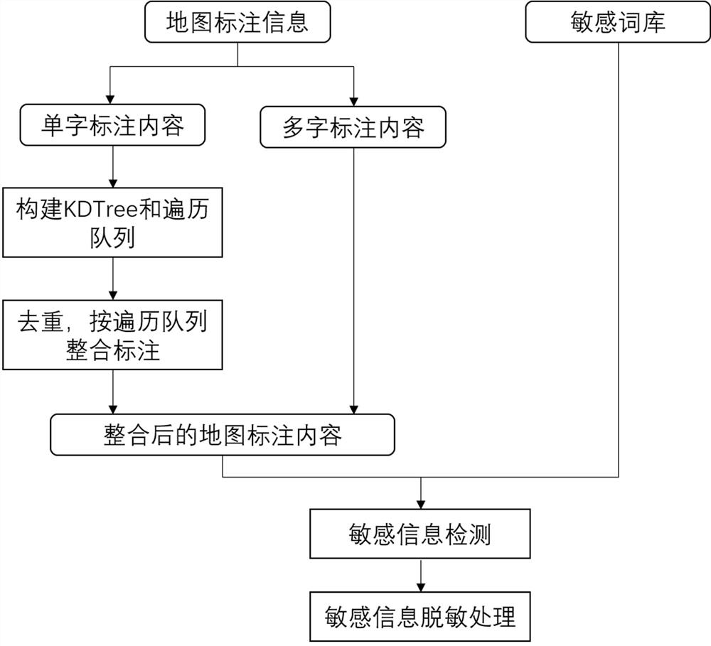
[0058] Such as figure 1 A kind of image database data processing method based on KDTree shown, comprises the following steps

[0059] (1) Traversal and integration of map annotation information based on KDTree;

[0060] (2) Sensitive information detection based on word similarity;

[0061] (3) Desensitization based on the sensitivity of feature words.

[0062] The specific content is as follows:

[0063] (1) A method for traversing and integrating map annotation information based on KDTree:

[0064] This method takes advantage of the correlation of the location distribution of the map label information, considers the points formed by all words, and greedily thinks that within a certain range, another point closest to the point where the current word is located can meet the conditions for integrating the two into words , when the conditions for integration into words cannot be met, other points will be considered within this range, and the specific process is as follows:

...


PUM


Abstract

The invention discloses a KDTree-based image database data processing method, comprising the following steps: step 1, traversing and integrating map labeling information based on KDTree to obtain label set S={s1,s2,...,sn}; step 2 Step 3: Perform corresponding desensitization processing according to the sensitivity level of the map annotation content. The present invention utilizes the location information marked on the map, realizes the traversal and integration of the marked content in the geospatial data and the automatic processing of sensitive information desensitization, and overcomes the cumbersome work, low efficiency, error-prone and loopholes under the existing manual processing. The phenomenon.

Description

technical field [0001] The invention relates to the field of geographic information data processing, in particular to a KDTree-based image database data processing method. Background technique [0002] In recent years, the rapid development of computer technology has promoted the development and progress of geographic information system technology. Geographic Information System (GIS) involves multiple disciplines such as geography, surveying and mapping, computer science and technology, using computers as tools, taking geospatial data as research objects, and combining the unique visualization effect of maps with geographic analysis. Functions are integrated with database operations to provide decision-making information for many industries and departments such as geography, planning and management. [0003] At present, with the development of mobile Internet, people's demand for geographic information-based services is increasing during their daily travel. The wide applic...

Claims


Application Information

Patent Timeline
Patent Type & Authority Patents(China)
IPC IPC(8): G06F16/22G06F16/29G06F21/57G06F21/62G06F40/289
CPCG06F21/577G06F21/6254G06F16/2246G06F16/29G06F40/289
Inventor 王浩秦拯陈嘉欣欧露
Owner HUNAN UNIV
Why Eureka
Try Eureka