Combined surveying instrument positioning and adjusting device for geological engineering surveying and mapping

A positioning adjustment and combined technology, which is applied in the direction of supporting machines, mechanical equipment, machine platforms/supports, etc., can solve the problems of overall convenience, efficiency and practicability, inconvenient fixing and adjustment of surveying instruments, cumbersome operation steps, etc. problems, to achieve overall convenience and high practicality, fast and convenient adjustment, and high surveying and mapping efficiency

Pending Publication Date: 2021-04-13
ANSHUN UNIV
View PDF0 Cites 2 Cited by
  • Summary
  • Abstract
  • Description
  • Claims
  • Application Information

AI Technical Summary

Problems solved by technology

[0002] Due to the general improvement of existing living conditions, roads in various places have been rebuilt and repaired, and geological engineering has been vigorously developed. In the process of road construction, combined surveying and mapping instruments are needed to survey and map corresponding road projects. In the process of surveying and mapping the corresponding road engineering, it is necessary to use the positioning adjustment device to fix and adjust the surveying instrument, but in the existing life, the design structure of the combined surveying instrument positioning adjustment device is too simple, which is very difficult for the fixing and adjustment of the surveying instrument. Inconvenient, not only the operation steps are very cumbersome, but also the adjustment limitations are relatively large. It is very inconvenient when using a combined surveying and mapping instrument to survey and map the road, and the surveying and mapping instrument cannot be adjusted according to the needs. The overall convenience, efficiency and practicability are common. It is not high, so for the improvement of the existing combined surveying and mapping instrument positioning adjustment device for geological engineering surveying and mapping, a new type of combined surveying and mapping instrument positioning and adjusting device for geological engineering surveying and mapping is designed to change the above technical defects and improve the overall geology. The practicability of the positioning adjustment device of the combined surveying and mapping instrument for engineering surveying and mapping is particularly important

Method used


Image

  • Combined surveying instrument positioning and adjusting device for geological engineering surveying and mapping
  • Combined surveying instrument positioning and adjusting device for geological engineering surveying and mapping
  • Combined surveying instrument positioning and adjusting device for geological engineering surveying and mapping

Examples


Embodiment

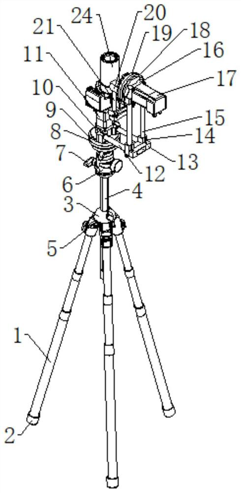
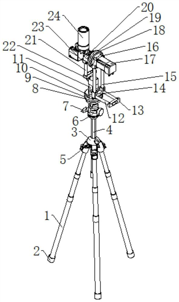
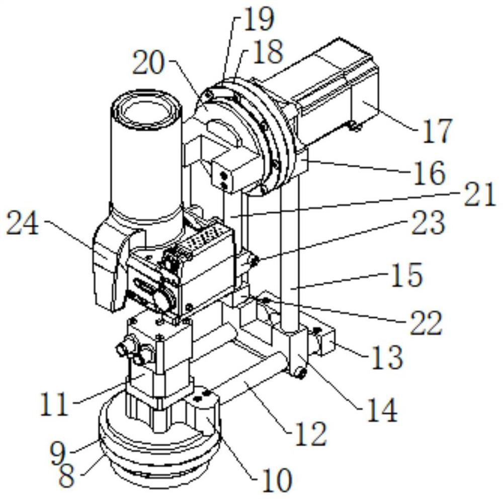
[0020] Examples, see Figure 1-3 , the present invention provides a technical solution: a combined surveying and mapping instrument positioning adjustment device for geological engineering surveying and mapping, including a support frame 1, the bottom of the support frame 1 is provided with an anti-skid sleeve 2, and the end of the support frame 1 is provided with a second A connecting seat 3, the first connecting rod 4 is plugged into the inside of the first connecting seat 3, the first adjusting knob 5 is correspondingly arranged on the outside of the first connecting seat 3, and the upper end of the first connecting rod 4 is connected with a second Connecting seat 6, the outside of the second connecting seat 6 is provided with a second adjustment knob 7 correspondingly, the upper surface of the second connecting seat 6 is connected with a first fixed disk 8, and a first rotating disk is arranged above the first fixed disk 8 9. The upper surface of the first rotating disk 9 ...


PUM


Abstract

The invention relates to the technical field of geological engineering surveying and mapping, in particular to a combined surveying instrument positioning and adjusting device for geological engineering surveying and mapping. The combined surveying instrument positioning and adjusting device comprises a support frame, an anti-skid sleeve is arranged at the bottom of the support frame, a first connecting base is arranged at the end part of the support frame, a first connecting rod is inserted into the first connecting base, a first adjusting knob is correspondingly arranged on the outer side of the first connecting base, a second connecting base is connected to the upper end of the first connecting rod, a second adjusting knob is correspondingly arranged on the outer side of the second connecting base, a first fixing disc is connected to the upper surface of the second connecting base, a first rotating disc is arranged above the first fixing disc, a first connecting part is arranged on the upper surface of the first rotating disc, and a first driving motor is arranged on the upper side of the first connecting part. According to the combined surveying instrument positioning and adjusting device, and through the design, the overall convenience, efficiency and practicability of the combined surveying instrument positioning and adjusting device for geological engineering surveying and mapping can be improved.

Description

technical field [0001] The invention relates to the technical field of geological engineering surveying and mapping, in particular to a combined surveying and mapping instrument positioning adjustment device for geological engineering surveying and mapping. Background technique [0002] Due to the general improvement of existing living conditions, roads in various places have been rebuilt and repaired, and geological engineering has been vigorously developed. In the process of road construction, combined surveying and mapping instruments are needed to survey and map corresponding road projects. In the process of surveying and mapping the corresponding road engineering, it is necessary to use the positioning adjustment device to fix and adjust the surveying instrument, but in the existing life, the design structure of the combined surveying instrument positioning adjustment device is too simple, which is very difficult for the fixing and adjustment of the surveying instrument....

Claims


Application Information

Patent Timeline
Patent Type & Authority Applications(China)
IPC IPC(8): F16M11/36F16M11/08F16M11/10F16M11/12F16M11/18
CPCF16M11/08F16M11/10F16M11/121F16M11/18F16M11/36
Inventor 黄兰椿
Owner ANSHUN UNIV
Why Eureka
Try Eureka