A method for automatic division of catchment area of ​​urban drainage pipe network

A drainage pipe network and automatic division technology, applied in the direction of neural learning methods, biological neural network models, instruments, etc., can solve the problem of low watershed division efficiency, achieve division accuracy improvement, speed up the modeling process, and improve modeling efficiency effect

Active Publication Date: 2021-11-19
HARBIN INST OF TECH
View PDF0 Cites 0 Cited by
  • Summary
  • Abstract
  • Description
  • Claims
  • Application Information

AI Technical Summary

Problems solved by technology

[0004] Aiming at the problem of low efficiency of existing water catchment division, the present invention provides an automatic division method of urban drainage pipe network water catchment

Method used


Image

  • A method for automatic division of catchment area of ​​urban drainage pipe network
  • A method for automatic division of catchment area of ​​urban drainage pipe network
  • A method for automatic division of catchment area of ​​urban drainage pipe network

Examples


specific Embodiment

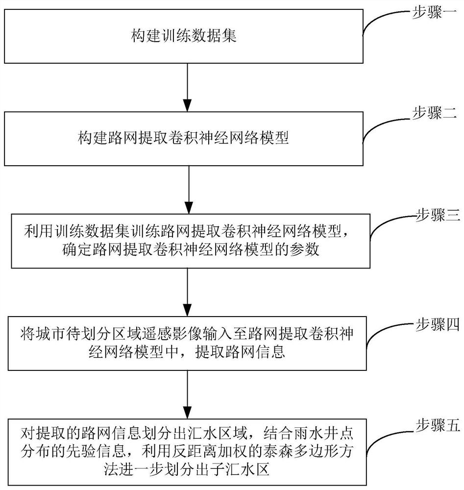
[0126] In a certain city A, the environment configuration uses an Intel(R) Core(TM) i9-9700K processor with a main frequency of 4.0GHz, a memory of 64GB, and an NVIDIA GTX 2080Ti graphics card with 11GB of video memory. The specific process is as follows:

[0127] Step 1. Image acquisition and preprocessing of the target area of ​​city A:

[0128] Use the omnipotent map downloader to download the remote sensing image and road extraction layer of city A from Google Earth; use ArcGIS to vectorize the remote sensing image and road extraction layer of the same geographical location and crop them into 1024×1024 primitives;

[0129] The preprocessing includes: performing HSV contrast transformation and spatial geometric transformation data enhancement processing on the original remote sensing image of city A; cutting the enhanced remote sensing image of city A and the road extraction layer according to 1024×1024; performing binary value processing on the road extraction layer proce...


PUM


Abstract

An automatic division method of urban drainage pipe network catchment area solves the problem of low efficiency of existing catchment area division, and belongs to the cross-application fields of environmental engineering, visible light remote sensing image semantic segmentation and computer vision. The present invention includes: S1, obtaining remote sensing images of urban target areas, and constructing a training data set; S2, using a convolutional neural network to couple a variant residual network to construct a road network extraction convolutional neural network model, and the variant residual network as a convolution The coding structure of the neural network; S3. Use the training data set to train the road network to extract the convolutional neural network model, and determine the parameters of the road network to extract the convolutional neural network model; S4. Input the remote sensing image of the city to be divided into the road network to extract the convolution In the neural network model, road network information is extracted; S5, the extracted road network information is divided into catchment areas, combined with the prior information on the distribution of rainwater well points, the inverse distance weighted Thiessen polygon method is used to further divide sub-catchment areas .

Description

technical field [0001] The invention relates to a method for automatically dividing urban drainage pipe network catchment areas based on a convolutional neural network coupling variant residual learning unit, and belongs to the cross-application fields of environmental engineering, visible light remote sensing image semantic segmentation, and computer vision. Background technique [0002] The establishment process of the urban drainage network model mainly includes the division of catchment area, the input of pipe section parameters, the parameter setting of key wading facilities, and the calibration of sensitivity parameters. Among them, the division of catchment areas is the basis for the construction of the entire drainage network model, and the accuracy of the division results directly affects the calculation accuracy of urban rainwater infiltration, evaporation and runoff processes. [0003] In the process of traditional urban drainage network modeling, the division of ...

Claims


Application Information

Patent Timeline
Patent Type & Authority Patents(China)
IPC IPC(8): G06K9/00G06K9/62G06N3/08G06K9/34G06Q50/26
CPCG06N3/08G06Q50/26G06V20/182G06V10/267G06F18/253G06F18/214
Inventor 田禹张天奇李铭马丽娜胡智超李俐频
Owner HARBIN INST OF TECH
Why Eureka
Try Eureka