Navigation positioning system for gravity gradient-terrain heterogeneous data matching

A gravity gradient, navigation and positioning technology, applied in the field of navigation, can solve the problems of limited application range of gravity navigation and positioning accuracy, etc.

Active Publication Date: 2021-04-30
BEIJING RES INST OF MECHANICAL & ELECTRICAL TECH
View PDF17 Cites 1 Cited by
  • Summary
  • Abstract
  • Description
  • Claims
  • Application Information

AI Technical Summary

Problems solved by technology

[0006] In view of the above analysis, the embodiment of the present invention aims to provide a gravity gradient-terrain heterogeneous data matching navigation and positioning system to solve the problem of limited application range and positioning accuracy of gravity navigation in the prior art

Method used


Image

  • Navigation positioning system for gravity gradient-terrain heterogeneous data matching
  • Navigation positioning system for gravity gradient-terrain heterogeneous data matching
  • Navigation positioning system for gravity gradient-terrain heterogeneous data matching

Examples


Embodiment 1

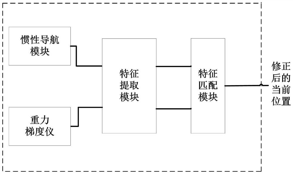
[0073] A specific embodiment of the present invention discloses a navigation and positioning system for gravity gradient-terrain heterogeneous data matching, such as figure 1 As shown, it includes: inertial navigation module, gravity gradiometer, feature extraction module, and feature matching module. Wherein, the output terminals of the inertial navigation module and the gravity gradiometer are respectively connected with the input terminals of the feature extraction module, and the output terminals of the feature extraction module are connected with the input terminals of the feature matching module.

[0074] The inertial navigation module is installed on the aircraft to be positioned, and is used to obtain the current position coordinates of the aircraft.

[0075] The gravity gradiometer is used to measure the gravity gradient tensor sequence of the route at equal time intervals.

[0076] The feature extraction module is used to extract the DQL features corresponding to th...

Embodiment 2

[0082] Improvement is made on the basis of the system in Embodiment 1, and the gravity gradiometer measures at intervals of time such as to obtain the gravity gradient tensor sequence (Γ) of n different positions (can include the current position) before the current position on the route. 1 Γ 2 … Γ n ); where, each element Γ in the sequence i Contains 9 components, satisfying

[0083] Γ i =(Γ xx Γ yy Γ zz Γ xy Γ yz Γ zx Γ xz Γ zy Γ yx ) i

[0084] i=1 2 ... n, n≥3 (1)

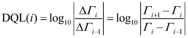
[0085] Preferably, the feature extraction module executes the following program to extract the DQL (Differential Quotient Logarithm, logarithmic scale difference space) feature corresponding to the above-mentioned gravity gradient tensor sequence:

[0086] S1. For each element in the gravity gradient tensor sequence, filter out the repeated components of the element by the following formula

[0087]

[0088] Obtaining only 5 independent components Γ i =(Γ xx Γ zz Γ xy Γ yz Γ ...

Embodiment 3

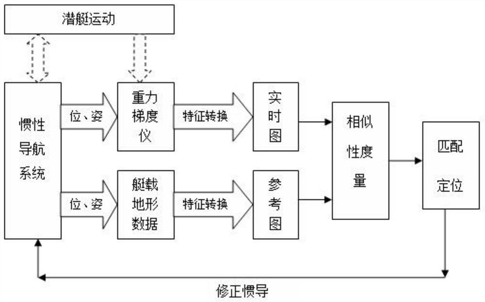
[0140] The present invention also provides a navigation and positioning method based on gravity gradient-terrain heterogeneous data matching corresponding to the system of Embodiment 1, including the following steps:

[0141] SS1. Obtain the current position coordinates of the aircraft and the gravity gradient tensor sequence of the route; specifically, the aircraft is an aircraft or an underwater vehicle;

[0142] SS2. Extracting the DQL features corresponding to the above gravity gradient tensor sequence;

[0143] SS3. Extract the DQL feature of the current position coordinates of the aircraft relative to the position coordinates of each terrain unit of the route in the topographic map;

[0144] SS4. Perform feature matching on the DQL features of the current position coordinates of the above-mentioned aircraft relative to the position coordinates of each terrain unit on the route in the topographic map, and the DQL features corresponding to the above-mentioned gravity gradi...


PUM


Abstract

The invention relates to a navigation positioning system for gravity gradient terrain heterogeneous data matching, belongs to the technical field of navigation, and solves the problem that the application range and the positioning precision of gravity navigation in the prior art are limited. The system comprises an inertial navigation module, a gravity gradiometer, a feature extraction module and a feature matching module, wherein the inertial navigation module is used for obtaining current position coordinates of an aircraft; the gravity gradiometer is used for measuring a gravity gradient tensor sequence of an airline where the gravity gradiometer is located; the feature extraction module is used for extracting DQL features corresponding to the gravity gradient tensor sequence and DQL features of current position coordinates of the aircraft relative to position coordinates of all terrain units of an airline where the aircraft is located in a topographic map; the feature matching module is used for carrying out feature matching on the two DQL features to obtain a gravity gradient tensor sequence element with the highest matching degree; and searching the position of the gravity gradient corresponding to the elements, and correcting the current position coordinates of the aircraft according to the position. The problem that existing gravity gradient matching navigation does not have large-range, high-precision and regularized global gravity field data is solved.

Description

technical field [0001] The invention relates to the technical field of navigation, in particular to a navigation and positioning system for gravity gradient-terrain heterogeneous data matching. Background technique [0002] For long-distance flying or long-term underwater navigation, the inertial navigation system (INS) is the core equipment for its navigation. However, the positioning error of the inertial navigation and positioning system continues to accumulate with time, so that it must be periodically calibrated by other auxiliary navigation means to ensure its positioning accuracy when it flies long distances or sails underwater for a long time. Auxiliary navigation methods such as celestial navigation, terrain matching navigation, radio navigation and GPS satellite navigation are often used for position correction, but radio and GPS satellite navigation need to radiate signals to the outside, which are easy to be detected and captured, while the conditions for use of ...

Claims


Application Information

Patent Timeline
Patent Type & Authority Applications(China)
IPC IPC(8): G01C21/16
CPCG01C21/16
Inventor 李海凤佟佳慧马杰张闻博李霖
Owner BEIJING RES INST OF MECHANICAL & ELECTRICAL TECH
Why Eureka
Try Eureka