Navigation and positioning method based on gravity gradient-terrain heterogenous data matching
What is AI technical title?
AI technical title is built by PatSnap AI team. It summarizes the technical point description of the patent document.
A gravity gradient, navigation and positioning technology, applied in the field of navigation, can solve the problems of limited application range of gravity navigation and positioning accuracy, etc.
Pending Publication Date: 2021-05-07
BEIJING RES INST OF MECHANICAL & ELECTRICAL TECH
View PDF0 Cites 1 Cited by
Summary
Abstract
Description
Claims
Application Information
AI Technical Summary
This helps you quickly interpret patents by identifying the three key elements:
Problems solved by technology
Method used
Benefits of technology
Problems solved by technology
[0006] In view of the above analysis, the embodiment of the present invention aims to provide a navigation and positioning method based on gravity gradient-terrain heterogeneous data matching to solve the problem of limited application range and positioning accuracy of gravity navigation in the prior art
Method used
Image
Click on the blue label to locate the original text in one second.
Reading with bidirectional positioning of images and text.
Examples
Embodiment 1
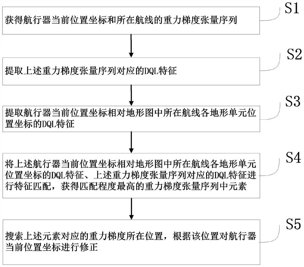
[0073] A specific embodiment of the present invention discloses a navigation and positioning method based on gravity gradient-terrain heterogeneous data matching, such as figure 1 shown, including the following steps:
[0074] S1. Obtain the current position coordinates of the aircraft and the gravity gradient tensor sequence of the route; specifically, the aircraft is an aircraft or an underwater vehicle;
[0075] S2. Identify and extract the DQL features corresponding to the above gravity gradient tensor sequence;
[0076] S3. Extract the DQL feature of the current position coordinates of the aircraft relative to the position coordinates of each terrain unit of the route in the topographic map;
[0077] S4. Perform feature matching on the DQL features of the current position coordinates of the above-mentioned aircraft relative to the position coordinates of each terrain unit of the route in the topographic map, and the DQL features corresponding to the above-mentioned gravi...
Embodiment 2
[0082] Improve on the basis of the method in Embodiment 1, step S1, the gravity gradient tensor sequence of obtaining the current position coordinates of the aircraft and the route where it is located, further includes:
[0083] S11. Obtain the current position coordinates (x, y, z) of the aircraft through the measurement of the inertial navigation module;
[0084] S12. Obtain the gravity gradient tensor sequence (Γ 1 Γ 2 … Γ n ); where, each element Γ in the sequence i Contains 9 components, satisfying
[0085] Γ i =(Γ xx Γ yy Γ zz Γ xy Γ yz Γ zx Γ xz Γ zy Γ yx ) i
[0086] i=1 2... n, n≥3
[0087] (1)
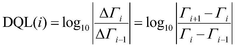
[0088] Preferably, in step S2, the extraction of the DQL (DifferentialQuotient Logarithm, logarithmic scale difference space) feature corresponding to the gravity gradient tensor sequence further includes:
[0089] S21. For each element in the gravity gradient tensor sequence, filter out the repeated components of the element by the following formu...
PUM
Abstract
The invention relates to a navigation and positioning method based on gravity gradient-terrain heterogenous data matching, belongs to the technical field of navigation, and aims to solve the problem that the gravity navigation application range and positioning precision are limited in the prior art. The method comprises the steps of: obtaining a current position coordinates of an aircraft and a gravity gradienttensor sequence of a route where the aircraft is located; extracting a DQL feature corresponding to the gravity gradienttensor sequence; extracting the DQL features of the current position coordinates of the aircraft relative to the position coordinates of each terrain unit of the route in a terrain map; performing feature matching on the DQL features of the current position coordinates of the aircraft relative to the position coordinates of each terrain unit of the route in the terrain map and the DQL features corresponding to the gravity gradient tensor sequence to obtain an element with the highest matching degree in the gravity gradient tensor sequence; and searching the position of a gravity gradient corresponding to the element, and correcting the current position coordinates of the aircraft according to the position. The application range and the positioning precision of gravity navigation are improved.
Description
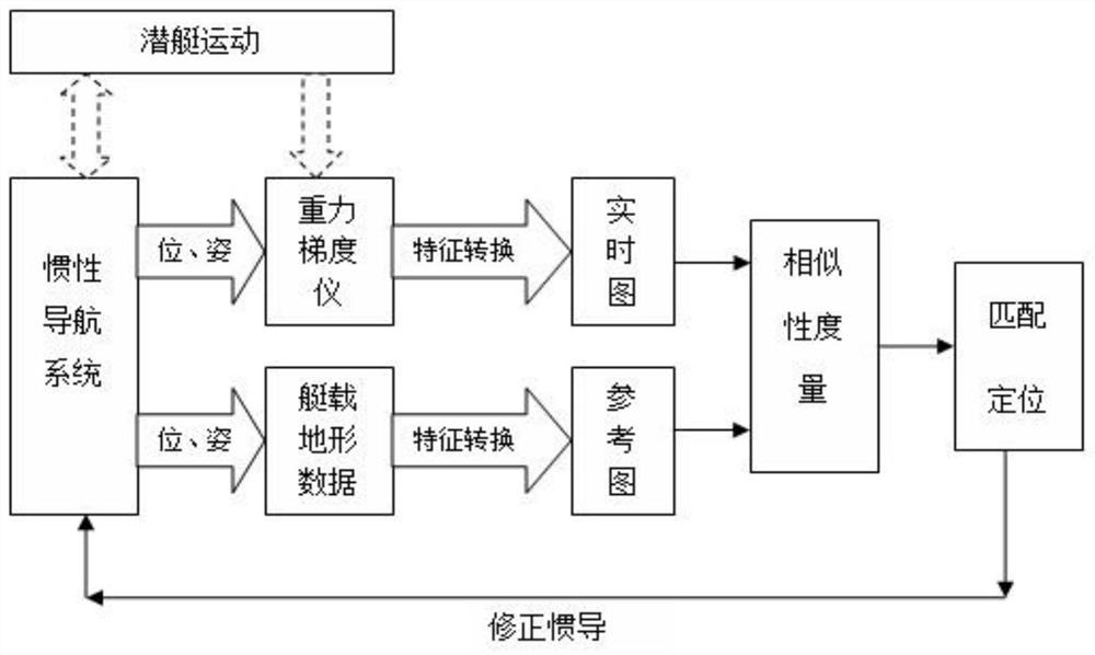
technical field [0001] The invention relates to the technical field of navigation, in particular to a navigation and positioning method based on gravity gradient-terrain heterogeneous data matching. Background technique [0002] For long-distance flying or long-term underwater navigation, the inertial navigation system (INS) is the core equipment for its navigation. However, the positioning error of the inertial navigation system continues to accumulate with time, so that it must be periodically calibrated by other auxiliary navigation means to ensure its positioning accuracy during long-distance flight or long-term underwater navigation. Auxiliary navigation methods such as celestial navigation, terrain matching navigation, radio navigation and GPS satellite navigation are often used for position correction, but radio and GPS satellite navigation need to radiate signals to the outside, which are easy to be detected and captured, while the conditions for use of celestial nav...
Claims
Application Information
Patent Timeline
Application Date:The date an application was filed.
Publication Date:The date a patent or application was officially published.
First Publication Date:The earliest publication date of a patent with the same application number.
Issue Date:Publication date of the patent grant document.
PCT Entry Date:The Entry date of PCT National Phase.
Estimated Expiry Date:The statutory expiry date of a patent right according to the Patent Law, and it is the longest term of protection that the patent right can achieve without the termination of the patent right due to other reasons(Term extension factor has been taken into account ).
Invalid Date:Actual expiry date is based on effective date or publication date of legal transaction data of invalid patent.
IPC IPC(8): G01C21/04G01C21/16
CPCG01C21/04G01C21/165
Inventor李海凤佟佳慧马杰张闻博李霖
OwnerBEIJING RES INST OF MECHANICAL & ELECTRICAL TECH

