A method for determining the yaw angle of wind rotors using unmanned aerial vehicles

A technology for determining the method and yaw angle, which is applied in the direction of unmanned aircraft, wind engine monitoring, aircraft, etc., can solve the problems of complex operation, large error, and high cost, and achieve high measurement accuracy, increase equipment cost, and yaw Angle-accurate effect

Active Publication Date: 2022-05-06
南京韦博智控科技有限公司
View PDF5 Cites 0 Cited by
  • Summary
  • Abstract
  • Description
  • Claims
  • Application Information

AI Technical Summary

Problems solved by technology

Among them, ground measurement refers to the traditional commonly used measurement method, which is mainly carried out on the ground. By setting up a ground-based scanner on the ground and using the ground-based scanner for data collection, the yaw angle can be obtained after analysis and processing, but the cost is high. ,low efficiency
However, in the actual use of the existing high-altitude measurement methods, the operation is complicated and the error is large

Method used


Image

  • A method for determining the yaw angle of wind rotors using unmanned aerial vehicles
  • A method for determining the yaw angle of wind rotors using unmanned aerial vehicles
  • A method for determining the yaw angle of wind rotors using unmanned aerial vehicles

Examples


Embodiment 1

[0057] A method for determining the yaw angle of a wind rotor by using an unmanned aerial vehicle provided by the present invention comprises the following steps:

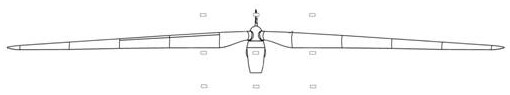
[0058] Step S1. First, according to the pre-input geographic coordinates of the wind turbine and the absolute altitude of the nacelle, a route for photogrammetry of the nacelle is generated, and the UAV collects images according to the photogrammetry route; secondly, the UAV’s airborne The calculation unit performs aerial triangulation calculations on the collected images according to known and mature methods, and produces point cloud results;

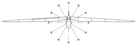
[0059] Among them, the route of photogrammetry is based on the geographic coordinates of the yaw rotation center point of the wind turbine and the absolute altitude of the nacelle as the center of collection, and generates a circle acquisition route centered on this point and the photogrammetry lens always points to this point Or reciprocating collection routes;

[0060] I...

Embodiment 2

[0069] A method for determining the yaw angle of a wind rotor by using an unmanned aerial vehicle, comprising the following steps:

[0070] Step S1. First, according to the pre-input geographic coordinates of the wind turbine and the absolute altitude of the nacelle, a route for photogrammetry of the nacelle is generated, and the UAV collects images according to the photogrammetry route; secondly, the UAV’s airborne The calculation unit performs aerial triangulation calculations on the collected images according to known and mature methods, and produces point cloud results;

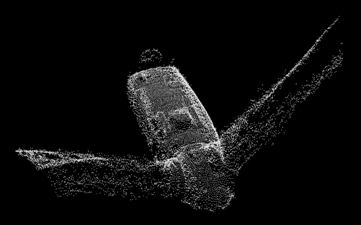
[0071] Step S2, slice the point cloud according to the elevation of the center point of the cabin, and process the point cloud into multiple independent slices of continuous elevation ranges;

[0072] Step S3, flattening each slice, such as Figure 9 As shown, the points within ±0.25m of the point cloud can be sliced ​​and flattened according to the elevation of the center point of the engine room. In th...

Embodiment 3

[0076] A method for determining the yaw angle of a wind rotor by using an unmanned aerial vehicle, comprising the following steps:

[0077] Step S1. First, according to the pre-input geographic coordinates of the wind turbine and the absolute altitude of the nacelle, a route for photogrammetry of the nacelle is generated, and the UAV collects images according to the photogrammetry route; secondly, the UAV’s airborne The calculation unit performs aerial triangulation calculations on the collected images according to known and mature methods, and produces point cloud results;

[0078] Step S2, slice the point cloud according to the elevation of the center point of the cabin, and process the point cloud into multiple independent slices of continuous elevation ranges;

[0079] Step S3, each slice is flattened, such as Figure 9 As shown, the points within ±0.25m of the point cloud can be sliced ​​and flattened according to the elevation of the center point of the engine room. In ...


PUM


Abstract

The invention discloses a method for determining the yaw angle of a wind rotor by using an unmanned aerial vehicle, which mainly utilizes the structural symmetry characteristics of the wind turbine's nacelle extending to the shroud, and according to the geographical coordinates of the wind generator input in advance and the position of the nacelle Absolute altitude, by obtaining the point cloud results of the position of the nacelle above the nacelle of the wind turbine, and then performing corresponding processing on the point cloud results, and then extracting the center line, so as to obtain accurate wind rotor yaw angle data. The invention can realize the measurement of the yaw angle with high measurement accuracy; the whole process is simple and does not require manual intervention, and the equipment for subsequent inspection of the fan blades is directly used for measurement and calculation without additional equipment cost.

Description

technical field [0001] The invention relates to a method for determining the yaw angle of a wind rotor by using an unmanned aerial vehicle, and belongs to the technical field of wind power generator inspection. Background technique [0002] As UAV equipment becomes more and more mature, in the scenario of wind power generation, the application of UAV autonomous inspection requirements for external dominant defects of wind turbine blades, shrouds, nacelles, towers and other components come behind. One of the important calculation basis for establishing the autonomous inspection route is the precise yaw angle of the wind turbine. Only when the yaw angle is determined can the three-dimensional coordinates of the center point of the wind wheel where the blades meet can be successively determined, and the three-dimensional coordinates of the center point It is the basic starting point of the autonomous inspection route. Therefore, accurate measurement of yaw angle is crucial to...

Claims


Application Information

Patent Timeline
Patent Type & Authority Patents(China)
IPC IPC(8): F03D17/00B64C39/02
CPCF03D17/00B64C39/02B64U2101/30
Inventor 王峰张福祥赵春雨
Owner 南京韦博智控科技有限公司
Why Eureka
Try Eureka