Geometry correction method for vehicle-mounted scanning point cloud in tunnel GNSS denied environment

A technology for geometric correction and scanning points, applied in the field of laser scanning and mapping, it can solve problems such as non-rigid deformation of point cloud data, and achieve high correction accuracy and efficiency, and the algorithm process is simple, reliable and accurate data support.

Active Publication Date: 2021-10-01
SICHUAN DEPT OF TRANSPORTATION HIGHWAY PLANNING PROSPECTING & DESIGN RES INST +1
View PDF8 Cites 0 Cited by
  • Summary
  • Abstract
  • Description
  • Claims
  • Application Information

AI Technical Summary

Problems solved by technology

[0006] The technical problem to be solved by the present invention is to provide a geometric correction method for vehicle-mounted scanning point clouds in a tunnel GNSS-denied environment, which can effectively solve: in tunnel surveying and mapping, especially in long tunnel surveying and mapping, due to the lack of GNSS signals in the surveying and mapping process The resulting non-rigid body deformation of the collected point cloud data

Method used


Image

  • Geometry correction method for vehicle-mounted scanning point cloud in tunnel GNSS denied environment
  • Geometry correction method for vehicle-mounted scanning point cloud in tunnel GNSS denied environment
  • Geometry correction method for vehicle-mounted scanning point cloud in tunnel GNSS denied environment

Examples


Embodiment

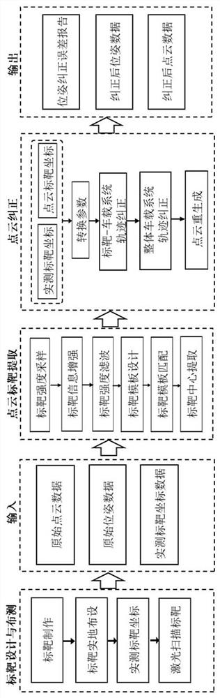
[0058] The geometric correction method of the vehicle-mounted scanning point cloud under the tunnel GNSS denial environment that this embodiment proposes comprises the following steps:

[0059] S1. In the tunnel area, carry out on-site target layout. The targets are arranged in groups along the tunnel extension direction. Each group includes more than 4 targets, and the interval between groups is set;

[0060] S2. Obtain the tunnel point cloud data including the point cloud data of each target through the surveying and mapping of the vehicle-mounted scanning system; measure the calibration point coordinates of each target through the tunnel measurement control network;

[0061] S3. Process the tunnel point cloud data, extract the corresponding target point cloud data in the point cloud data, and further obtain the calibration points between the target point cloud data and the measured target according to the extracted target point cloud data Corresponding point coordinates of ...


PUM


Abstract

The invention belongs to the field of laser scanning surveying and mapping, and provides a geometric correction method for vehicle-mounted scanning point clouds in a tunnel GNSS-denied environment, which can solve the problem of point cloud geometric correction of non-rigid body deformation in the tunnel area, thereby meeting the demand for high-precision point cloud collection . In the present invention, firstly, the targets are arranged in groups along the extension direction of the tunnel; secondly, the point cloud data is obtained through the surveying and mapping of the vehicle-mounted scanning system, and the calibration point coordinates of each target are obtained through actual measurement; thirdly, the point cloud data obtained from the vehicle-mounted scanning system Extract the three-dimensional coordinates of the same name point corresponding to the target; then, calculate the conversion parameters between the measured target coordinates and the point cloud target coordinates in groups, correct the vehicle-mounted scanning system trajectory position corresponding to each group of targets, and in other to-be-corrected The trajectory area complements the trajectory of the mobile measurement system by interpolation method; finally, the accurate trajectory of the corrected mobile measurement system is recalculated to obtain high-precision long tunnel point cloud data.

Description

technical field [0001] The invention belongs to the field of laser scanning surveying and mapping, and in particular relates to a geometric correction method for vehicle-mounted scanning point clouds in a tunnel GNSS-denied environment. Background technique [0002] With the development of vehicle-mounted mobile 3D laser measurement systems, this technology, as a way of acquiring geospatial data, has become the main data source for 3D point cloud data acquisition in large scenes. It plays a vital role in the field of application, and has great potential in highway planning management, operation and maintenance, digital modeling and asset element extraction. [0003] However, the point cloud data acquisition accuracy of this technology depends on a good continuous GNSS signal. The GNSS is the abbreviation of Global Navigation Satellite System, and the full Chinese name is Global Navigation Satellite System. Therefore, in the surveying and mapping of long tunnels with a lengt...

Claims


Application Information

Patent Timeline
Patent Type & Authority Patents(China)
IPC IPC(8): G01C15/00G01C21/20
CPCG01C15/002G01C21/20
Inventor 李升甫葛旭明廖知勇汪镇东贾洋汪致恒刘霜辰许濒支姚周祥
Owner SICHUAN DEPT OF TRANSPORTATION HIGHWAY PLANNING PROSPECTING & DESIGN RES INST
Why Eureka
Try Eureka