Four-dimensional remote sensing ecological index construction method based on spatial geometry principle

A technology of ecological index and construction method, applied in geographic information database, data processing application, structured data retrieval, etc., can solve problems such as ambiguous physical meaning and inability to evaluate ecological status as a whole

Active Publication Date: 2021-09-17
FUZHOU UNIV
View PDF5 Cites 3 Cited by
  • Summary
  • Abstract
  • Description
  • Claims
  • Application Information

AI Technical Summary

Problems solved by technology

[0003] Most remote sensing data are used in the evaluation of ecological conditions to use remote sensing data to evaluate a certain aspect of the ecology from a single perspective, but it is impossible to evaluate the ecological conditions as a whole.
Some researchers integrate multiple indicators through principal component transformation or factor analysis methods ...

Method used


Image

  • Four-dimensional remote sensing ecological index construction method based on spatial geometry principle
  • Four-dimensional remote sensing ecological index construction method based on spatial geometry principle
  • Four-dimensional remote sensing ecological index construction method based on spatial geometry principle

Examples


Embodiment Construction

[0115] The present invention will be further described below in conjunction with the accompanying drawings and embodiments.

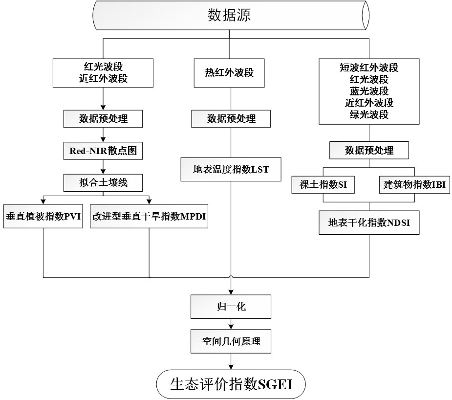
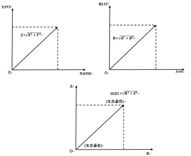
[0116] Please refer to figure 1 , the present invention provides a kind of four-dimensional remote sensing ecological index (SGEI) construction method based on spatial geometry principle, comprising the steps of:

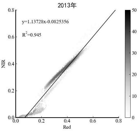
[0117] Step S1: Obtain and preprocess Landsat remote sensing data including blue light, green light, red light, near-infrared, short-wave infrared, and thermal infrared bands in the study area, and fit the soil line according to the red-light band and near-infrared two-dimensional space scatter diagram and find the soil line equation:

[0118] The specific steps of step S1 are as follows:

[0119] Step S11: Obtain the remote sensing data of the study area in the blue light, green light, red light, near-infrared, short-wave infrared, and thermal infrared bands of Landsat in the study area, perform geometric correction, radiation calibration,...


PUM


Abstract

The invention relates to a four-dimensional remote sensing ecological index construction method based on a spatial geometry principle. Four indexes including a vertical vegetation index PVI representing vegetation, an improved earth surface drought index MPDI representing drought degree, an earth surface drying index NDSI representing earth surface drying degree and an earth surface temperature index LST representing earth surface temperature are coupled; a space geometry principle is introduced to construct a four-dimensional space respectively representing four elements of greenness, drought, drying degree and temperature which have relatively great influence on ecology; and then a comprehensive remote sensing ecological index SGEI is calculated. The SGEI contains all information contents of the four indexes, and the influence of the four indexes on the SGEI is determined according to the property of the data, so that certain objectivity is achieved, and the physical significance and rationality of the SGEI are effectively improved. The SGEI can be used for rapidly monitoring and evaluating regional ecological conditions.

Description

technical field [0001] The invention relates to the field of remote sensing ecological index construction, in particular to a four-dimensional remote sensing ecological index construction method based on spatial geometry principles. Background technique [0002] In recent years, regional ecological evaluation indicators have gradually been paid attention to by people. As an important means of quantitative evaluation of regional ecological environment, remote sensing has been widely used. Remote sensing repeatedly acquires data in a certain period, and at the same time, it can observe large areas synchronously, and truly reflect the changes in the regional ecological environment, and quickly obtain the attribute characteristics of the target object, so as to perform ecological evaluation. [0003] Most remote sensing data are used in the evaluation of ecological status to use remote sensing data to evaluate a certain aspect of the ecology from a single perspective, but it is ...

Claims


Application Information

Patent Timeline
IPC IPC(8): G06Q10/06G06Q50/26G06F16/29
CPCG06Q10/06393G06Q50/26G06F16/29
Inventor 汪小钦林梦婧苏华
Owner FUZHOU UNIV
Why Eureka
Try Eureka