Practical atmospheric correction method for remote sensing images

A technique for atmospheric correction and remote sensing imagery, applied in the use of re-radiation, re-radiation of electromagnetic waves, measurement devices, etc.

Inactive Publication Date: 2009-12-09
CENT FOR EARTH OBSERVATION & DIGITAL EARTH CHINESE ACADEMY OF SCI
View PDF0 Cites 48 Cited by
  • Summary
  • Abstract
  • Description
  • Claims
  • Application Information

AI Technical Summary

Problems solved by technology

[0004] The purpose of the present invention is to provide a method for atmospheric correction of remote sensing images to overcome the shortcomings of the existing DOS model

Method used


Image

  • Practical atmospheric correction method for remote sensing images
  • Practical atmospheric correction method for remote sensing images
  • Practical atmospheric correction method for remote sensing images

Examples


Embodiment Construction

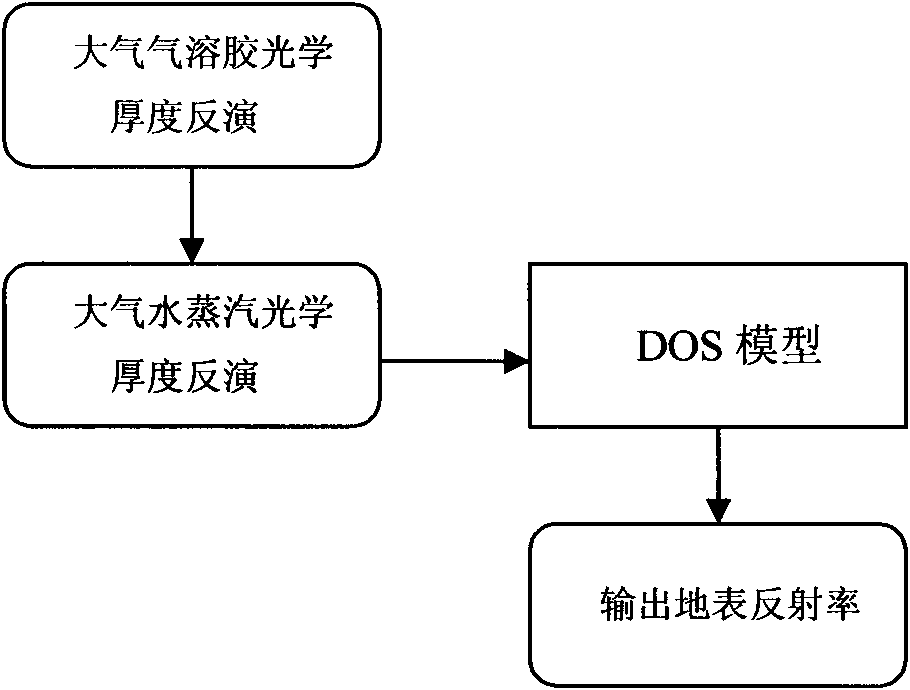
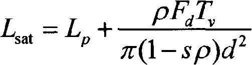
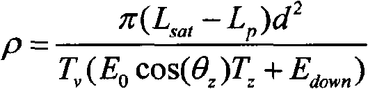
[0025] The inversion of remote sensing surface reflectance is based on the radiative transfer equation. Assuming a uniform surface, Lambertian surface reflection, and uniform atmospheric properties, and ignoring multiple scattering in the atmosphere, the relationship between the radiance of the star and the surface reflectance is as follows: 1 [Kaufman Y J, Sendra C. Algorithm for automatic atmospheric correction to visible and near-IRsatellite imagery, International Journal of Remote Sensing, 1988, 9 (8): 1357-1381.]:

[0026] L sat = L p + ρ F d T v π ( 1 - sρ ) d 2 ...


PUM


Abstract

The invention discloses a practical atmospheric correction method for remote sensing images, which comprises three steps: a first step, inverting the optical thickness of atmospheric aerosol from MODIS data by means of a 6S model lookup table based on a dense vegetation algorithm; a second step, calculating total content of atmospheric vapor by using an MODIS data band ratio method, and then calculating the optical thickness of the atmospheric vapor; and a third step, combining the inverted optical thickness of the atmospheric aerosol, the optical thickness of the atmospheric vapor and a DOS model to invert the earth surface reflectance. The calculated earth surface reflectance has high precision; the method has strong practicability, and is applicable to various land satellite images; and the MODIS data can be acquired freely every day; therefore, the method can be used as a service atmospheric correction method for the remote sensing images.

Description

technical field [0001] The invention relates to a method for atmospheric correction of remote sensing images, which can be applied to remote sensing departments such as agriculture, forestry, meteorology, ecological environment, national defense and military affairs. Background technique [0002] Atmospheric correction of remote sensing images is an important preprocessing step before surface albedo retrieval. In remote sensing atmospheric correction research, accurate atmospheric correction requires atmospheric sounding data measured synchronously at the moment of satellite transit, but it is often difficult to obtain such data. The ideal atmospheric correction method only needs the information of the image itself without satellite transit Time synchronization measurement data, dark object subtraction (Dark Object Subtraction, DOS) is produced to meet this need. The basic principle of this method is to assume that the remote sensing image to be corrected has a dark pixel a...

Claims


Application Information

Patent Timeline
Patent Type & Authority Applications(China)
IPC IPC(8): G01B21/08G01S17/88
Inventor 张兆明何国金
Owner CENT FOR EARTH OBSERVATION & DIGITAL EARTH CHINESE ACADEMY OF SCI
Why Eureka
Try Eureka