Binocular rapid three-dimensional measurement method for unmanned aerial vehicle

A drone and binocular technology, applied in photogrammetry/video metrology, measuring devices, surveying and mapping and navigation, etc., can solve low operating efficiency, emergency and labor costs, large time cost investment, complicated processes, etc. problem, to achieve the effect of fast and high-precision measurement

Pending Publication Date: 2022-04-22
CHINESE ACAD OF SURVEYING & MAPPING
View PDF0 Cites 0 Cited by
  • Summary
  • Abstract
  • Description
  • Claims
  • Application Information

AI Technical Summary

Problems solved by technology

[0005] The traditional or recent 3D modeling of UAVs has a complicated overall process, low op

Method used


Image

  • Binocular rapid three-dimensional measurement method for unmanned aerial vehicle
  • Binocular rapid three-dimensional measurement method for unmanned aerial vehicle
  • Binocular rapid three-dimensional measurement method for unmanned aerial vehicle

Examples


Embodiment Construction

[0017] The technical solutions in the embodiments of the present invention are clearly and completely described below in conjunction with the accompanying drawings in the embodiments of the present invention. Obviously, the described embodiments are only part of the embodiments of the present invention, not all of them. It does not constitute a limitation of the present invention. Based on the embodiments of the present invention, all other embodiments obtained by persons of ordinary skill in the art without making creative efforts belong to the protection scope of the present invention.

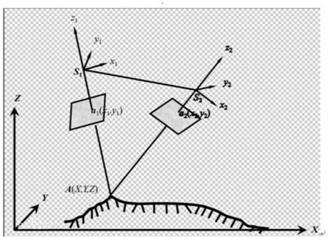
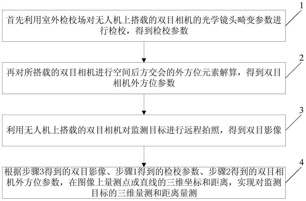
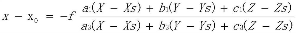
[0018] Such as figure 1 Shown is a schematic flow chart of the UAV binocular fast three-dimensional measurement method provided by the embodiment of the present invention, and the method includes:

[0019] Step 1. First, use the outdoor calibration field to calibrate the optical lens distortion parameters of the binocular camera mounted on the drone to obtain the calibration parameters;

...


PUM


Abstract

The invention discloses a binocular rapid three-dimensional measurement method for an unmanned aerial vehicle, and the method comprises the steps: firstly carrying out the calibration of an optical lens distortion parameter of a binocular camera carried on the unmanned aerial vehicle through an outdoor calibration field, and obtaining a calibration parameter; performing spatial resection exterior orientation element calculation on the carried binocular camera to obtain exterior orientation parameters of the binocular camera; a binocular camera carried on the unmanned aerial vehicle is used for carrying out remote photographing on a monitoring target, and a binocular image is obtained; and according to the obtained binocular image, the calibration parameter and the exterior orientation parameter of the binocular camera, measuring the three-dimensional coordinate and the distance of a point or a straight line on the image, thereby realizing three-dimensional measurement and distance measurement of the monitored target. According to the method, a binocular camera carried by an unmanned aerial vehicle is used for realizing rapid and high-precision measurement of a target, and sub-millimeter-level measurement precision can be achieved within a distance of 10 meters.

Description

technical field [0001] The invention relates to the technical field of three-dimensional measurement of unmanned aerial vehicle, in particular to a binocular fast three-dimensional measurement method of unmanned aerial vehicle. Background technique [0002] In recent years, the use of drones in surveying technology has gradually broken through the limitations of traditional aerial survey accuracy. Combined with image control technology, it has been able to meet the accuracy requirements of large-scale topographic maps such as 1:500, 1:1000, and 1:2000. In the past, surveying and mapping operations required a large number of manual points on the ground to obtain high-precision data. Not only was it time-consuming and labor-intensive, but its rationality was also highly dependent on the experience of the operator, and even local conditions such as signals, traffic, and geographical terrain. In the case of tight schedule and cost, surveying and mapping staff can only minimize t...

Claims


Application Information

Patent Timeline
IPC IPC(8): G01C11/00
CPCG01C11/00
Inventor 李永荣刘正军张赓陈一铭苏国中
Owner CHINESE ACAD OF SURVEYING & MAPPING
Why Eureka
Try Eureka