Method for realizing dynamic point ground feature annotation of GIS

A technology of geographic information system and implementation method, which is applied in the field of dynamic annotation of points, ground objects, and can solve problems such as inability to display annotations, blurred maps, incomplete display, etc.

Inactive Publication Date: 2006-02-08
WUHAN HONGXIN TELECOMM TECH CO LTD
View PDF0 Cites 11 Cited by
  • Summary
  • Abstract
  • Description
  • Claims
  • Application Information

AI Technical Summary

Problems solved by technology

[0003] 1. When the marked feature is at the border of the map or the screen, the mark cannot be displayed or the display is incomplete;
[0004] 2. When the number of ground features on the map is relatively large and the graphic display scale is relatively small, there will be a phenomenon that the marks of the ground features overlap each other, and the marks cover the ground features, which will cause the entire map to be blurred

Method used


Image

  • Method for realizing dynamic point ground feature annotation of GIS
  • Method for realizing dynamic point ground feature annotation of GIS

Examples


Embodiment Construction

[0012] Further illustrate the present invention below in conjunction with accompanying drawing.

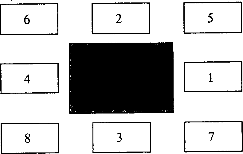
[0013] exist figure 1 , there are a total of eight labeling positions around the point and feature rectangle to be displayed. It is necessary to determine eight labeling center points, and calculate the labeling rectangle centered on this point, and determine the priority, which is 1-8 respectively. When displaying this When labeling a point, first judge whether the labeling rectangle with the highest priority level intersects with other point labeling rectangles, and whether it intersects with other point graphic rectangles. The annotation rectangle does not intersect any other annotation rectangle. If no disjoint rectangle can be found after looping through eight locations, the annotation of this point will not be displayed.

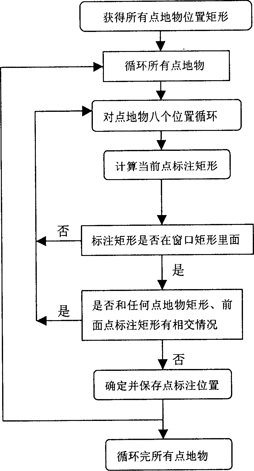
[0014] figure 2 The specific processing flow of the present invention is described. First, the position rectangle of the position of the point needs t...


PUM


Abstract

The invention relates to a method for achieving geography information system object dynamic labeling. The object labeling location can be dynamically adjusted by the real condition; it dose quoting before labeling the object, if the object picture is inside the map window and the labeling content is outside the map window, the system can automatically find out a location inside the window around the object so as to display the labeling inside the map window, if the object labeling location covers the front object picture or the object labeling, the system can automatically find out a vacancy location inside the window around the object so as to undertake the object labeling do not cover the front object picture or the object labeling.

Description

technical field [0001] The invention relates to a method for realizing dynamic annotation of points, features and features in a geographic information system. Background technique [0002] In geographic information systems, traditional labeling techniques are static: the position of labeling information relative to the marked features is fixed. There are two main problems with this technique: [0003] 1. When the marked feature is at the border of the map or the screen, the mark cannot be displayed or the display is incomplete; [0004] 2. When the number of ground features on the map is relatively large and the graphic display scale is relatively small, there will be a phenomenon that the marks of the ground features overlap each other, and the marks cover the ground features, which will cause the entire map to be blurred. This problem can be alleviated by layered display of map content, but the above problem will still occur when there are a large nu...

Claims


Application Information

Patent Timeline
Patent Type & Authority Applications(China)
IPC IPC(8): G09B29/00
Inventor 周训飞吴玲琦章文涛邓先礼许诺菲
Owner WUHAN HONGXIN TELECOMM TECH CO LTD
Why Eureka
Try Eureka