Device for temporarily overcoming the loss of a satellite navigation signal, for satellite navigation-based dual toll systems

a satellite navigation and dual toll system technology, applied in wave based measurement systems, navigation instruments, instruments, etc., can solve the problems of no toll charge calculation, no ability for anonymous debiting, and no longer possible position determination

Inactive Publication Date: 2005-03-31
SIEMENS AG
View PDF5 Cites 34 Cited by
  • Summary
  • Abstract
  • Description
  • Claims
  • Application Information

AI Technical Summary

Benefits of technology

[0011] One advantageous feature of an embodiment of the invention is that the use of a road which is subject to a toll can be verified even when no permanent communication is possible between a position determination system and the vehicle, since the signature of the road being driv

Problems solved by technology

This method has the particular disadvantage that the position of the vehicle must be recorded all the time, and there is no capability for anonymous debiting.
One disadvantage of the known method is that no toll charges can be calculated if the communication link between the vehicle and the payment center or between the v

Method used


Image

  • Device for temporarily overcoming the loss of a satellite navigation signal, for satellite navigation-based dual toll systems
  • Device for temporarily overcoming the loss of a satellite navigation signal, for satellite navigation-based dual toll systems
  • Device for temporarily overcoming the loss of a satellite navigation signal, for satellite navigation-based dual toll systems

Examples


Embodiment Construction

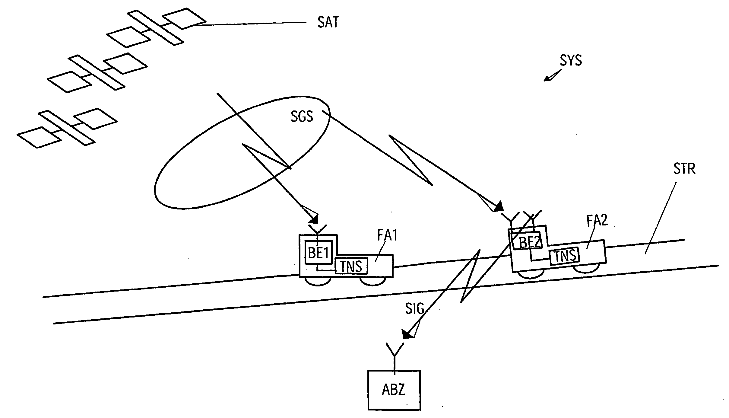
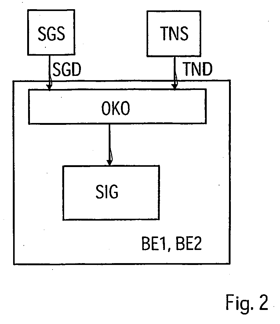
[0022] As is shown in FIG. 1, a toll system SYS according to an embodiment of the invention for location of a vehicle FA1, FA2 has a satellite-based position finding system SGS, for example the known “Global Positioning System” or GPS system, for short, as well as an inertial navigation system TNS which is arranged on board the vehicle FA1, FA2. As will be explained in more detail in the following text, the toll system SYS according to an embodiment of the invention allows a dual toll system to be produced in a simple manner.

[0023] For the purposes of this document, a dual toll system is a toll system which allows not only payment of the toll charges directly to a toll-payment apparatus, which is designed specifically for this purpose, in the vehicle without any communication with a payment center external to the vehicle, but also allows payment of toll charges via a payment center ABZ, with the vehicle in the second case having to have a toll-payment apparatus which is designed fo...


PUM


Abstract

The invention relates to a method for electronically charging tolls, whereby actual position coordinates (OKO) of a vehicle are determined by means of at least one position fixing system, in order to determine if a toll road segment has been taken. Said position coordinates (OKO) are determined at least temporarily by means of a satellite-aided position fixing system (SGS). At least one signature (SIG), which is characteristic of the road segment taken by said vehicle, is calculated by means of said position coordinates of the vehicle (FA1, FA2). Said signature (SIG) permits the determination of whether the road segment taken is a toll road segment or not. At least in case of partial failure of said satellite-aided position fixing system (SGS), the position coordinates are determined by means of an inertial navigation system (TNS).

Description

[0001] This application is the national phase under 35 U.S.C. § 371 of PCT International Application No. PCT / DE02 / 03921 which has an International filing date of Oct. 16, 2002, which designated the United States of America and which claims priority on Austrian Patent Application number AT 1680 / 2001. filed Oct. 22, 2001, the entire contents of which is hereby incorporated herein by reference.FIELD OF THE INVENTION [0002] The invention generally relates to a method for electronic toll payment, Preferably, it relates to one in which, in order to determine whether the road which is being driven on is subject to toll, current position coordinates of a vehicle are determined. This is preferably done by using at least one position determination system, with the position coordinates being determined at least at times by way of a satellite-based position determination system. [0003] The invention also generally relates to a toll system for electronic toll payment. Preferably, it relates to o...

Claims


Application Information

Patent Timeline
IPC IPC(8): G01C21/28G07B15/06
CPCG07B15/063G01C21/28
Inventor GILA, JANOSKONRAD, WOLFGANG
Owner SIEMENS AG
Why Eureka
Try Eureka