
Navigation system

a navigation system and navigation technology, applied in navigation instruments, surveying and navigation, instruments, etc., can solve problems such as roads that the vehicle cannot travel on

Active Publication Date: 2006-12-07
CLARION CO LTD
View PDF2 Cites 25 Cited by
  • Summary
  • Abstract
  • Description
  • Claims
  • Application Information

AI Technical Summary

Benefits of technology

[0012] According to the 8th aspect of the invention, in the navigation system according to the 5th or the 6th aspect, it is preferred that the route setting unit brings up a display that allows the link corresponding to the route error to be removed from the route having been set and removes the link corresponding to the route error from the route having been set in response to a cancel instruction.

Problems solved by technology

The navigation system disclosed in Japanese Laid Open Patent Publication No. 2000-111354 allows the user to set any road on which he wishes to travel by tracing the road on the screen with his finger and thus, a problem arises that a road which the vehicle cannot travel due to traffic control, e.g., a one-way street, may be set as part of the route.

Method used


Image

  • Navigation system
  • Navigation system
  • Navigation system

Examples


Embodiment Construction

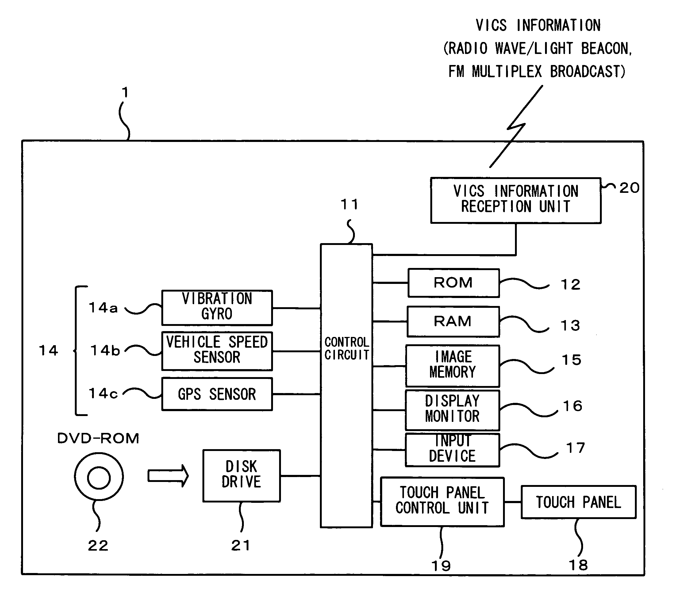
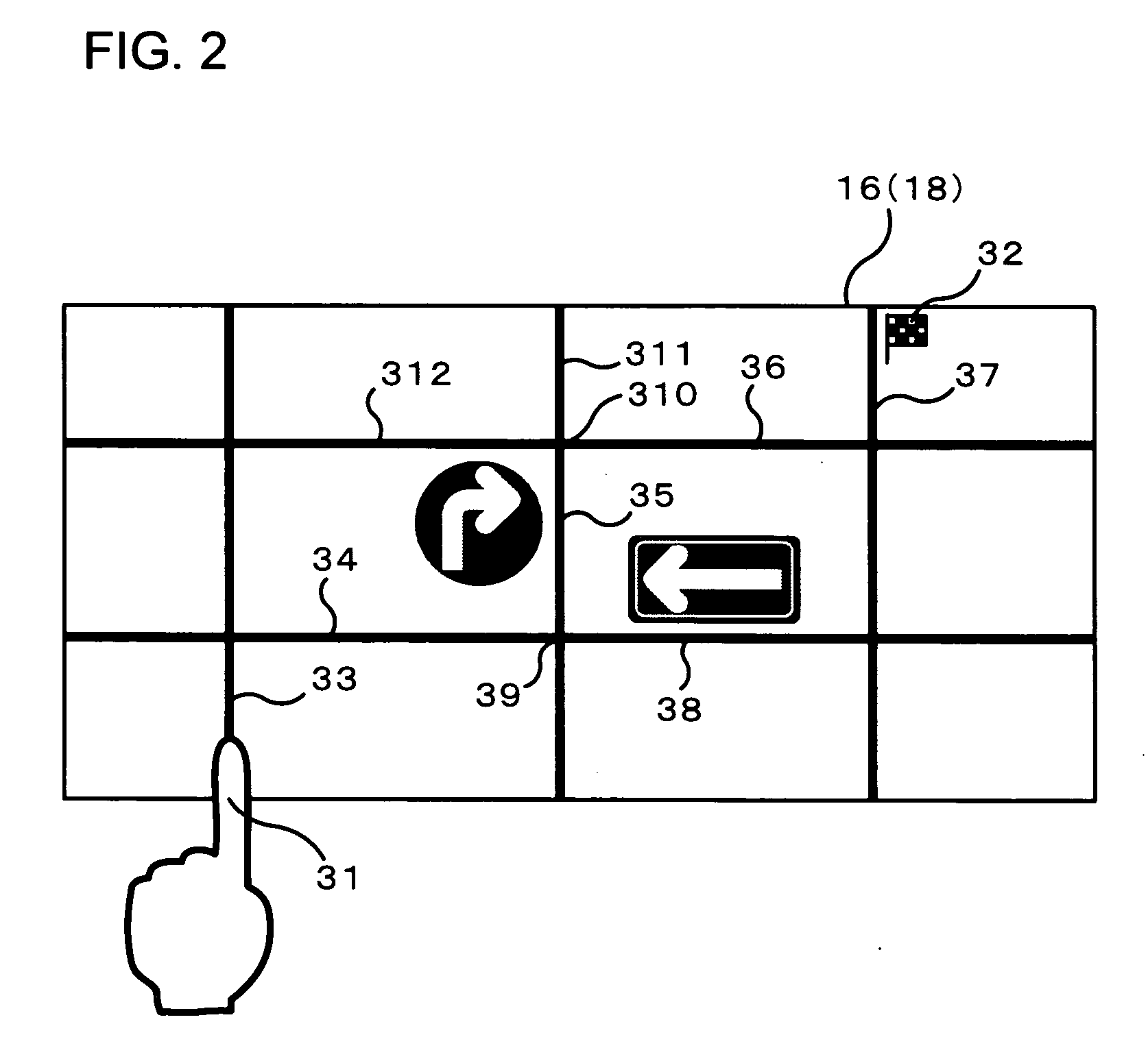
[0024]FIG. 1 shows the structure adopted in the navigation system achieved in an embodiment of the present invention. The navigation system 1 in FIG. 1, which is installed in a vehicle, allows a route to a destination to be set by tracing the route on a touch panel 18. The navigation system 1 includes a control circuit 11, a ROM 12, a RAM 13, a current position detection device 14, an image memory 15, a display monitor 16, an input device 17, the touch panel 18, a VICS (road traffic information system) information reception unit 20 and a disk drive 21.

[0025] The touch panel 18 is a transparent touch switch laminated over the surface of the display monitor 16. An image displayed at the display monitor 16 is viewed through the touch panel 18. A signal corresponding to an operating position on the touch panel 18 is output from the touch panel 18 to a touch panel control unit 19, which then calculates the depressed position on the touch panel 18. A DVD-ROM 22 having recorded therein ma...


PUM


Abstract

According to the 1st aspect of the invention, a navigation system comprises: a storage unit that stores map data managed with links representing smallest road units; a road map display unit that displays a road map based upon the map data; a depressed position detection unit that detects a depressed position on the road map on display; and a route setting-unit that extracts a corresponding link corresponding to the depressed position and sets the extracted corresponding link as a route to a destination based upon the map data, and the route setting unit extracts a link adjacent to the corresponding link and makes a decision as to whether or not the adjacent link can be entered from the corresponding link based upon the map data.

Description

INCORPORATION BY REFERENCE [0001] The disclosure of the following priority application is herein incorporated by reference: Japanese Patent Application No. 2005-128097 filed Apr. 26, 2005 FIELD OF THE INVENTION [0002] The present invention relates to a navigation system that allows a route to a destination to be set with a finger tracing a road on-display. DESCRIPTION OF RELATED ART [0003] There is a navigation system known in the related art that allows the user to set a road on which he wishes to travel by tracing the road on display at the display screen with his finger or a touch pen while setting a route to the destination (see Japanese Laid Open Patent Publication No. 2000-111354) SUMMARY OF THE INVENTION [0004] The navigation system disclosed in Japanese Laid Open Patent Publication No. 2000-111354 allows the user to set any road on which he wishes to travel by tracing the road on the screen with his finger and thus, a problem arises that a road which the vehicle cannot trave...

Claims


Application Information

Patent Timeline
Patent Type & Authority Applications(United States)
IPC IPC(8): G01C21/00
CPCG01C21/3664G01C21/3461
Inventor MATSUOKA, YOJIISHIDA, TERUYUKIMUTOU, KEISUKEKONDA, HIROAKIYOSHIMARU, TAKASHIISHII, TAKAAKINOMURA, MAMIOWAKI, TSUGUMICHI
Owner CLARION CO LTD
Learn More