Topographic map display device for aircraft

a technology for aircraft and topographic maps, applied in the direction of navigation instruments, instruments, process and machine control, etc., can solve the problems of crew confusion and poor interpretation of the map, and achieve the effect of improving the accuracy of the map

Inactive Publication Date: 2007-07-26
THALES SA
View PDF7 Cites 51 Cited by
  • Summary
  • Abstract
  • Description
  • Claims
  • Application Information

AI Technical Summary

Benefits of technology

[0036] a FIG. 6 represents an exemplary distribution formed by minimum safety altitudes associated with the elements of the tiling of FIG. 5 and covered, even partially, by the emergency descent zone illustrated in FIGS. 3 and 5,
[0037] a FIG. 7 is a vertical terrain section showing the forms of the terrain strata repr

Problems solved by technology

However, such a map has a very different appearance from that of visual alarms showing the threatening reliefs and obstacles on the ground and the switch from one to the other at the moment of the appearance or of the disappearance of a visual alarm may engender poor interpretations on the part of the crew.
At the transition, the meaning of the colors chang

Method used


Image

  • Topographic map display device for aircraft
  • Topographic map display device for aircraft
  • Topographic map display device for aircraft

Examples


Embodiment Construction

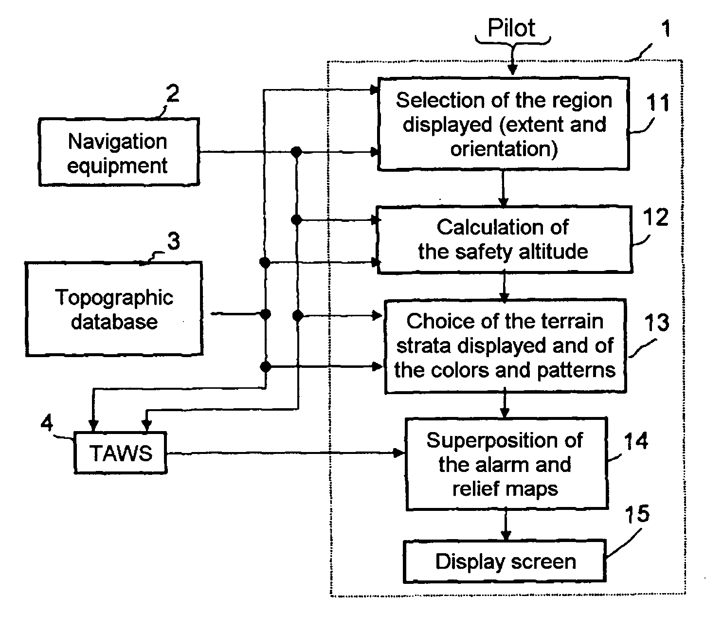
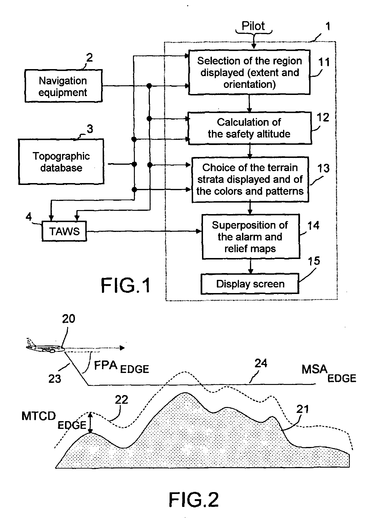
[0039] The topographic map display device 1 for aircraft, which is shown in FIG. 1, is associated with the navigation equipment 2 of the aircraft, with a topographic database 3 carried onboard the aircraft or accessible from the latter by radio communication, and with a ground proximity warner 4 of TAWS type.

[0040] The navigation equipment 2 provides current position and current altitude to the topographic map display device 1 and to the ground proximity warning system 4. The topographic database 3 covers, with a mesh of measurement points, the domain of deployment of the aircraft which is a more or less extensive part of the terrestrial surface and provides the topographic map display device 1 and the ground proximity warner TAWS 4 with the topographic elements allowing one of them, the topographic map display device 1, to formulate a map of the relief of the region overflown and the other one, the ground proximity warning system TAWS 4, to formulate a map of the region overflown ...


PUM


Abstract

This display device displays a 2D topographic map corresponding to terrain sections with mainly horizontal profile referenced with respect to an absolute altitude that is greater than that of the highest surrounding relief, which is termed the safety altitude MSAEDGE and which is deduced from the minimum safety altitudes of the points of the zone of largest probability of presence of the aircraft in the course of an emergency descent.

Description

BACKGROUND OF THE INVENTION [0001] 1. Field of the Invention [0002] The present invention pertains to topographic map display onboard aircraft, in particular onboard aircraft equipped with ground proximity warning systems displaying, on the instrument panel, visual alarms pinpointing on a map the reliefs and obstacles on the ground considered to be threatening. [0003] 2. Description of the Related Art [0004] It has long been known to display on the instrument panel of an aircraft a topographic map of the region overflown by utilizing the current position provided by the navigation instruments of the aircraft to extract from a topographic database a 2D map of the relief of the region overflown plotted on the basis of the level lines. However, such a map has a very different appearance from that of visual alarms showing the threatening reliefs and obstacles on the ground and the switch from one to the other at the moment of the appearance or of the disappearance of a visual alarm may ...

Claims


Application Information

Patent Timeline
IPC IPC(8): G01C23/00B64D45/04G01C5/00G09B29/10G09B29/12
CPCG01C23/005G09B29/12G09B29/106
Inventor BITAR, ELIASMARTY, NICOLAS
Owner THALES SA
Why Eureka
Try Eureka