Method for interpreting seismic data and controlled source electromagnetic data to estimate subsurface reservoir properties

Inactive Publication Date: 2008-07-03
OFFSHORE HYDROCARBON MAPPING +1
View PDF0 Cites 16 Cited by
  • Summary
  • Abstract
  • Description
  • Claims
  • Application Information

AI Technical Summary

Problems solved by technology

However, the portion of subsurface formations which can be measured by such well log and core data is limited in areal extent, e.g. to about six to twelve inches a

Method used


Image

  • Method for interpreting seismic data and controlled source electromagnetic data to estimate subsurface reservoir properties
  • Method for interpreting seismic data and controlled source electromagnetic data to estimate subsurface reservoir properties
  • Method for interpreting seismic data and controlled source electromagnetic data to estimate subsurface reservoir properties

Examples


Embodiment Construction

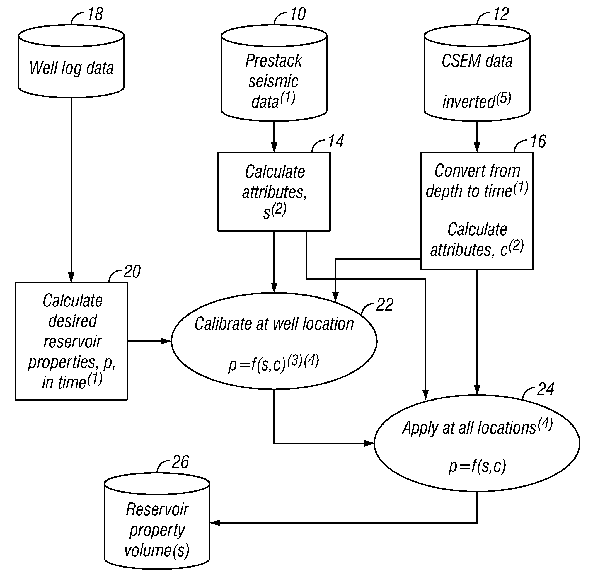
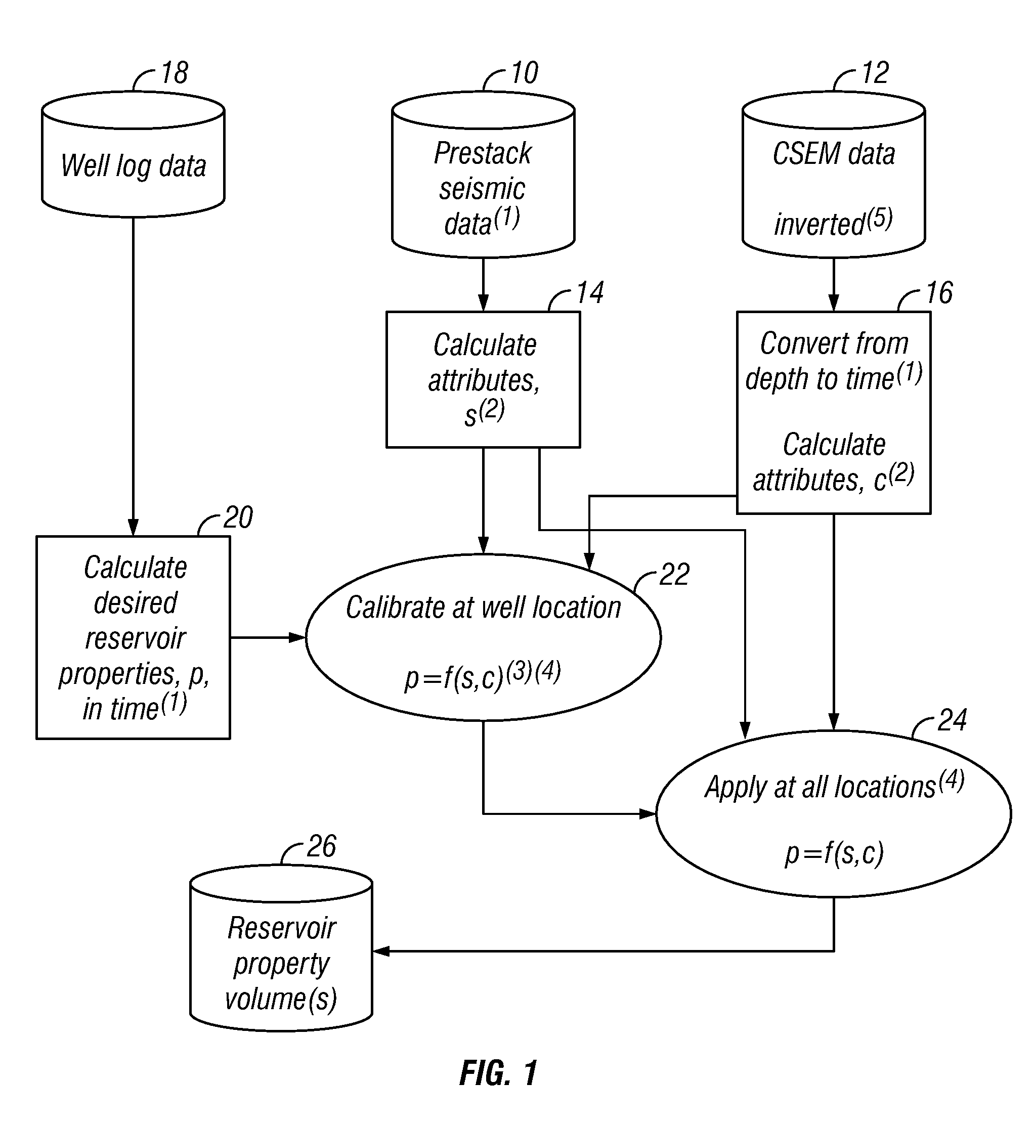
[0021]One embodiment of a method according to the invention will be explained with reference to the flow chart in FIG. 1. The method of the invention makes use, in some embodiments, of data acquired from one or more wellbores drilled through subsurface Earth formations in an area of interest. Data acquired from the wellbore may include so called “well log” data. Such data are typically made in the form of a record with respect to depth in the subsurface of various physical parameters measured by instruments lowered into the wellbore. Such instruments may include, for example, electrical resistivity, acoustic velocity, bulk density, neutron slowing down length, neutron capture cross section, natural gamma radiation, fluid pressure in the pore spaces and time derivatives thereof, and nuclear magnetic resonance relaxation time distribution, among others. Well data may also include analyses of actual samples of the subsurface formations, such as fractional volume of pore space in any pa...


PUM


Abstract

A method for mapping a property of a subsurface reservoir includes determining a value of at least one reservoir property from measurements obtained from a well drilled through the reservoir. A relationship is determined between the at least one property of the reservoir and at least one seismic attribute and at least one electromagnetic survey attribute at a geodetic position of the well. A value of the at least one reservoir property is determined at at least one other geodetic position from a value of the at least one seismic attribute, a value of the at least one electromagnetic survey attribute at the at least one other geodetic position, and from the determined relationship.

Description

CROSS-REFERENCE TO RELATED APPLICATIONS[0001]Continuation in part of application Ser. No. 11 / 646,935 filed on Dec. 28, 2006.STATEMENT REGARDING FEDERALLY SPONSORED RESEARCH OR DEVELOPMENT[0002]Not applicable.BACKGROUND OF THE INVENTION[0003]1. Field of the Invention[0004]The invention relates generally to the field of subsurface Earth exploration using seismic and electromagnetic survey data. More specifically, the invention is related to methods for using seismic and electromagnetic data that have been correlated to subsurface well data to provide estimates of reservoir properties in locations separated from the location of the well data.[0005]2. Background Art[0006]Seismic exploration for oil and gas is performed by use of a source of seismic energy and the reception of the energy generated by the source by an array of seismic detectors. On land, the source of seismic energy may be a high explosive charge or another energy source having the capacity to deliver a series of impacts ...

Claims


Application Information

Patent Timeline
IPC IPC(8): G01V1/30G01V1/40
CPCG01V3/083G01V2210/6163G01V11/00G01V2210/6161
Inventor HARRIS, PETERMACGREGOR, LUCY
Owner OFFSHORE HYDROCARBON MAPPING
Why Eureka
Try Eureka