Method of Determining Mode of Transportation in a Personal Navigation Device

a navigation device and mode of transportation technology, applied in navigation instruments, surveying and navigation, instruments, etc., can solve the problems of many functionalities that are as yet unexplored and unimplemented

Active Publication Date: 2011-05-05
MITAC INT CORP
View PDF25 Cites 31 Cited by
  • Summary
  • Abstract
  • Description
  • Claims
  • Application Information

AI Technical Summary

Problems solved by technology

However, many functionalities are as yet unexplored and unimplemented, one of which is automatic determination of mode of transportation based on the information in the GPS device.

Method used


Image

  • Method of Determining Mode of Transportation in a Personal Navigation Device
  • Method of Determining Mode of Transportation in a Personal Navigation Device
  • Method of Determining Mode of Transportation in a Personal Navigation Device

Examples


Embodiment Construction

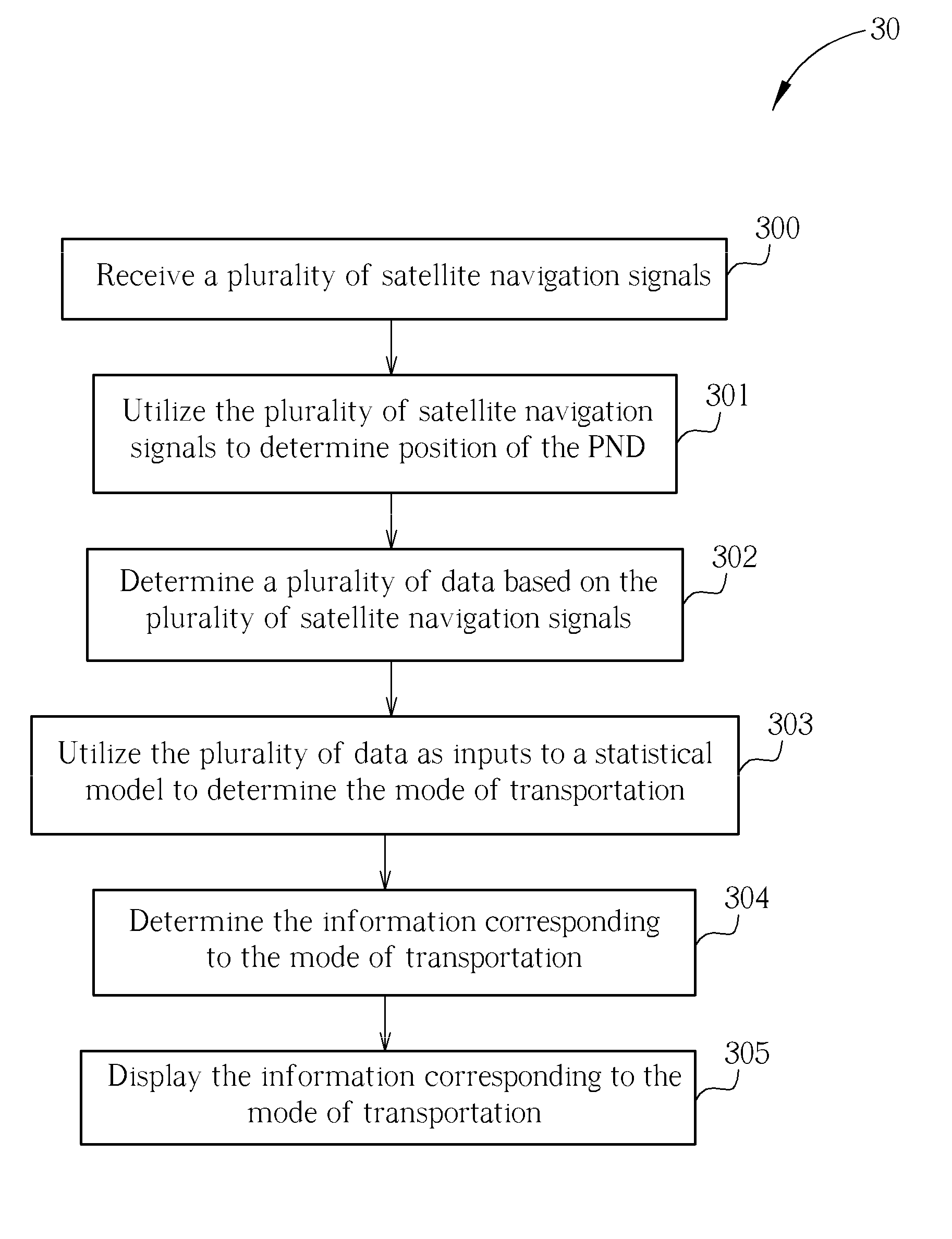
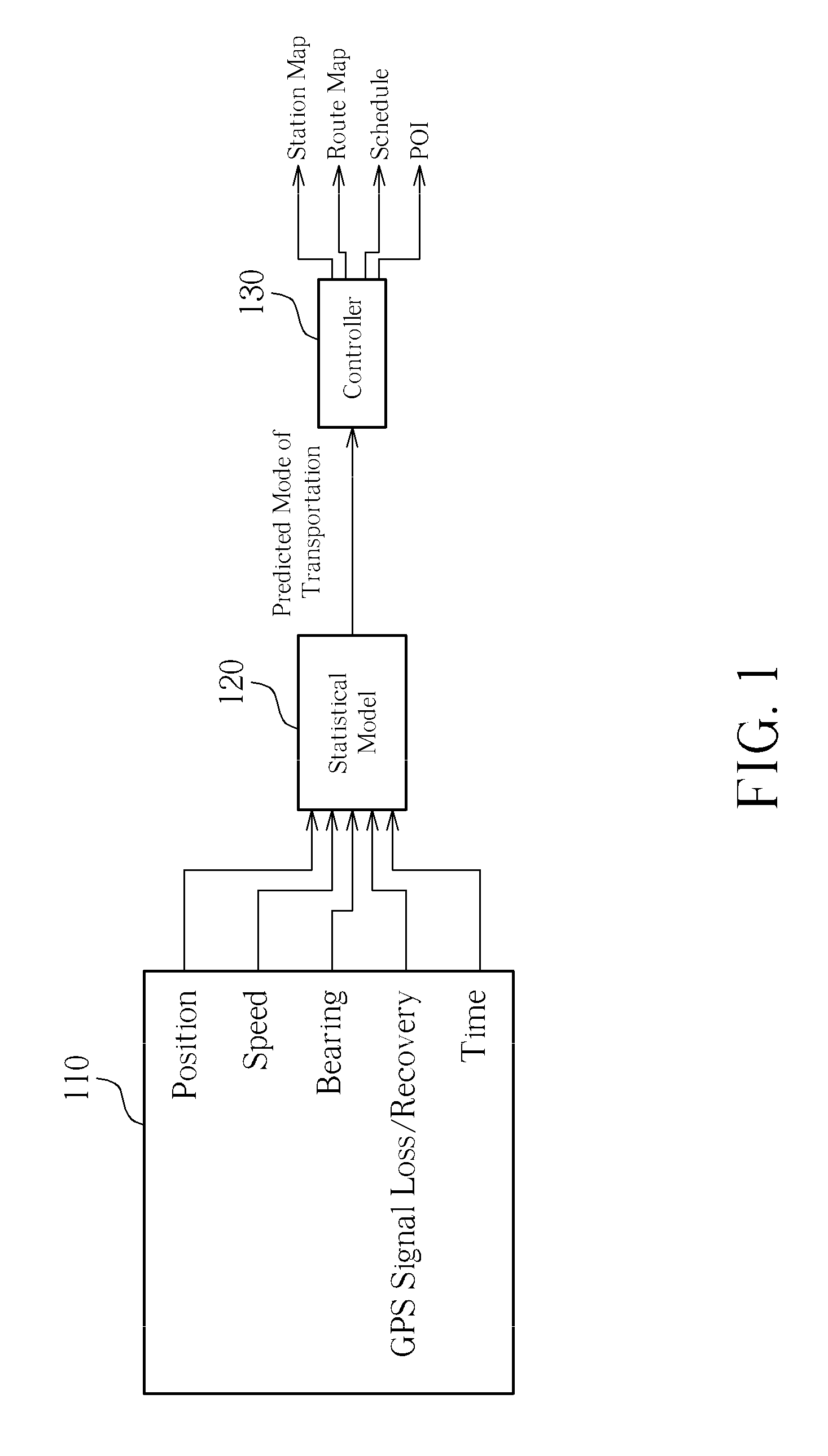
[0015]Please refer to FIG. 1, which is a diagram of a method of determining a mode of transportation according to an embodiment of the present invention. A personal navigation device (PND) determines the mode of transportation. The method may be implemented in any navigation device that utilizes a Global Navigation Satellite System to determine its position. As shown in FIG. 1, the PND is able to sense or calculate a plurality of data 110, which may include, for example, position of the PND, speed of the PND, bearing of the PND, loss and recovery of satellite signals received by the PND, and the current time of day. The time of day may be determined from incoming GPS satellite signals, or simply from an internal clock of the PND. The position of the PND may be determined through trilateration of the incoming satellite signals, and may be used in coordination with mapping software to determine an address corresponding to the position, including street number, street, city, state / prov...


PUM


Abstract

To provide useful information to a user of a personal navigation device (PND) related to their current mode of transportation the PND receives a plurality of satellite navigation signals, utilizes the plurality of satellite navigation signals to determine position of the PND, determines a plurality of data based on the plurality of satellite navigation signals, utilizing the plurality of data as inputs to a statistical model to determine the mode of transportation, determines the information corresponding to the mode of transportation, and displays the information corresponding to the mode of transportation.

Description

BACKGROUND OF THE INVENTION[0001]1. Field of the Invention[0002]The present invention relates to personal navigation devices (PNDs), and more particularly, to a method of determining a mode of transportation in a PND.[0003]2. Description of the Prior Art[0004]A number of navigation methods have been employed over the centuries by sailors desiring to go from one place to another without getting lost on the way or passing through dangerous waters. Whereas in the past, navigation was typically of interest to navigators on marine vessels, as more advanced navigation systems are developed, drivers, hikers, and tourists are rapidly adopting Global Navigation Satellite System (GNSS) technology to aid them in their travels.[0005]One key to navigation is positioning, or the art of knowing precisely where one is at any given moment. In the past, positioning was accomplished through use of a sextant, which measures angular positions of celestial bodies relative to the horizon. Today, positioni...

Claims


Application Information

Patent Timeline
Patent Type & Authority Applications(United States)
IPC IPC(8): G01C21/00
CPCG01C21/3423
Inventor MORLEY, SIMON DEAN
Owner MITAC INT CORP
Why Eureka
Try Eureka