Geospatial modeling system providing poisson-based geospatial data set merging and related methods

a geospatial data and model technology, applied in the field of data modeling, can solve problems such as difficult implementation of the approach, voids or gaps in data, and not being well suited to 3d data models

Inactive Publication Date: 2012-07-12
HARRIS CORP
View PDF1 Cites 11 Cited by
  • Summary
  • Abstract
  • Description
  • Claims
  • Application Information

AI Technical Summary

Benefits of technology

[0014]This and other objects, features, and advantages are provided by a geospatial modeling system which may include a geospatial model data storage device, and a processor cooperating with the geospatial model data storage device for merging first and second geospatial data sets for corresponding first and second geospatial regions. The processor may be for generating seam-smoothed geospatial data for a corresponding selected geospatial region between adjacent portions of the first and second geospatial regions by applying Poisson's equation to data from at least one of the first and second geospatial data sets for the selected geospatial region using boundary conditions. This may be done based upon data along corresponding interfaces between the selected geospatial region and adjacent portions of the first and second geospatial regions. Accordingly, the system may advantageously merge geospatial data sets with little or no detectable or visible seams therebetween.

Problems solved by technology

In many instances there will be voids or gaps in the data used to generate a geospatial or other model.
While this approach is well suited for communication and audio signals, it may not be well suited for 3D data models.
This approach is sometimes difficult to implement because the computational overhead may become overly burdensome for higher order polynomials, which may be necessary to provide desired accuracy.
While this approach may provide a relatively high reconstruction accuracy, this approach may be problematic to implement in a 3D data model because of the difficultly in solving a global spline over the entire model, and because the required matrices may be ill-conditioned.
One further drawback of such conventional techniques is that they tend to blur edge content, which may be a significant problem in a 3D topographical model.

Method used


Image

  • Geospatial modeling system providing poisson-based geospatial data set merging and related methods
  • Geospatial modeling system providing poisson-based geospatial data set merging and related methods
  • Geospatial modeling system providing poisson-based geospatial data set merging and related methods

Examples


Embodiment Construction

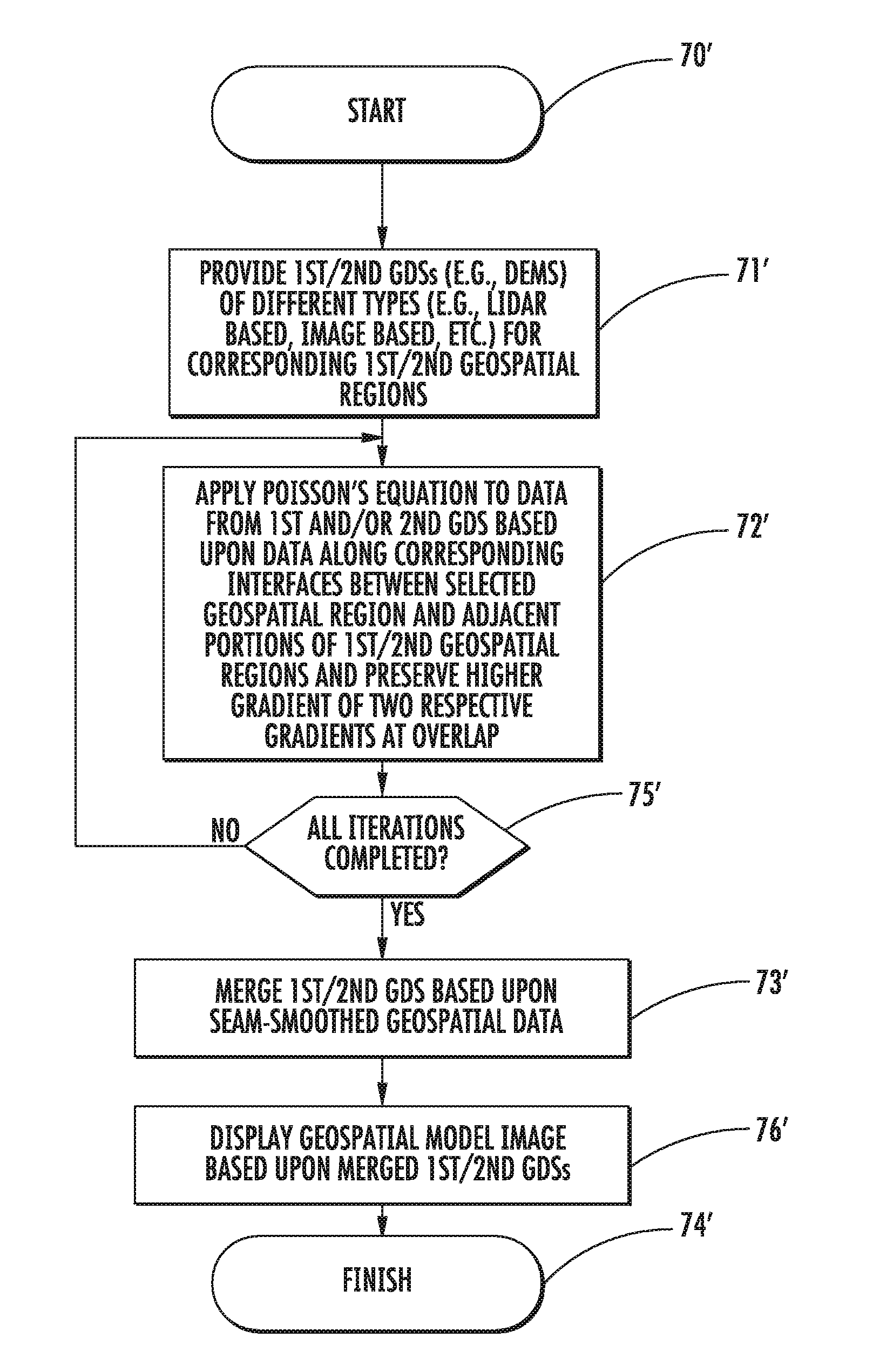
[0025]The present invention will now be described more fully hereinafter with reference to the accompanying drawings, in which preferred embodiments of the invention are shown. This invention may, however, be embodied in many different forms and should not be construed as limited to the embodiments set forth herein. Rather, these embodiments are provided so that this disclosure will be thorough and complete, and will fully convey the scope of the invention to those skilled in the art. Like numbers refer to like elements throughout, and prime notation is used to indicate similar elements in alternate embodiments.

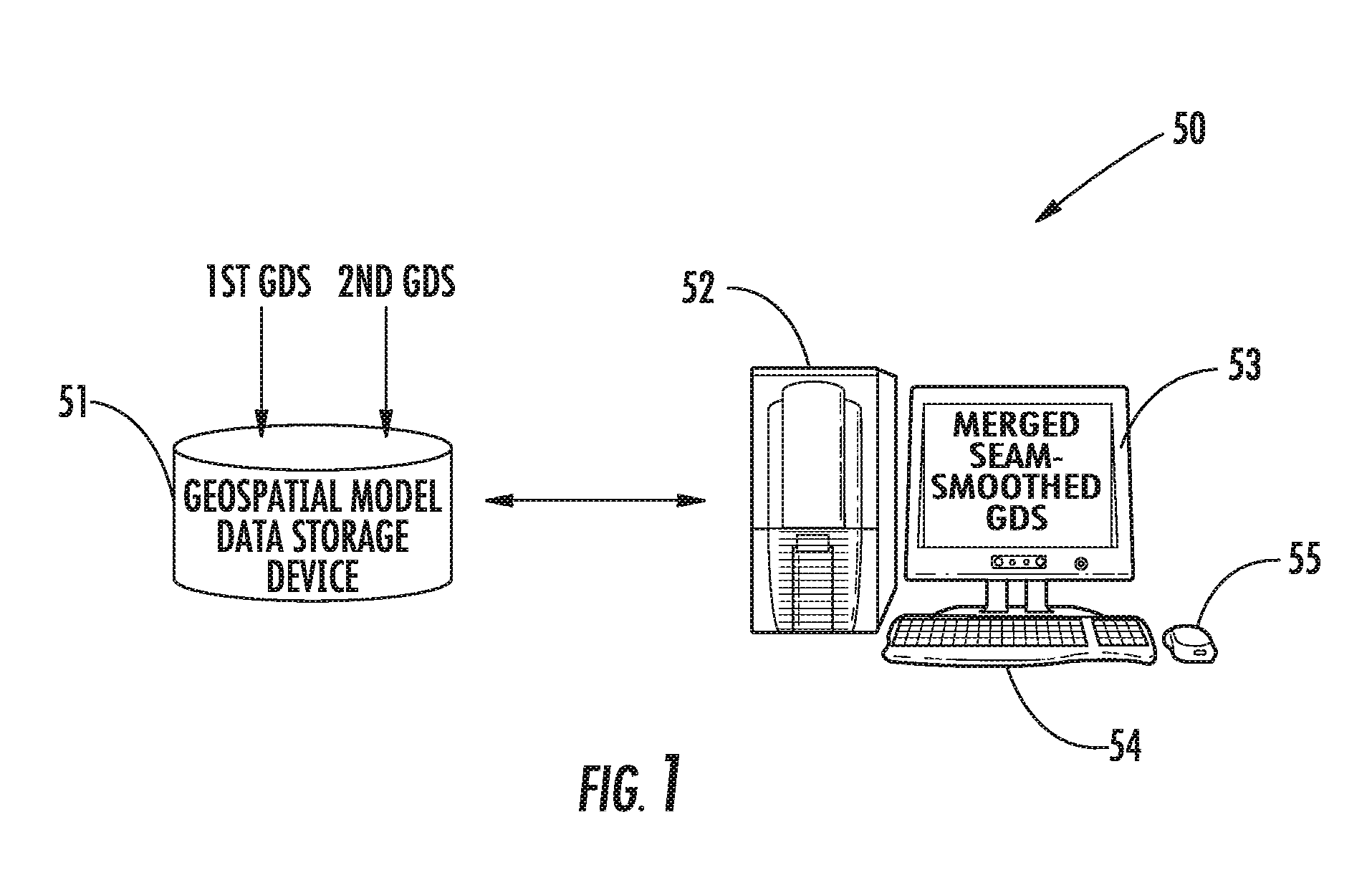
[0026]Referring initially to FIGS. 1 through 4, a geospatial modeling system 50 and associated method aspects of the invention are first described. The system 50 illustratively includes a geospatial model data storage device 51 and a processor 52, which may include a central processing unit (CPU) of a PC, Mac, or other computing workstation, for example. A display 53 may be c...


PUM


Abstract

A geospatial modeling system may include a geospatial model data storage device, and a processor cooperating with the geospatial model data storage device for merging first and second geospatial data sets for corresponding first and second geospatial regions. The processor may be for generating seam-smoothed geospatial data for a corresponding selected geospatial region between adjacent portions of the first and second geospatial regions by applying Poisson's equation to data from at least one of the first and second geospatial data sets for the selected geospatial region using boundary conditions based upon data along corresponding interfaces between the selected geospatial region and adjacent portions of the first and second geospatial regions.

Description

FIELD OF THE INVENTION[0001]The present invention relates to the field of data modeling, and, more particularly, to modeling systems such as geospatial modeling systems and related methods.BACKGROUND OF THE INVENTION[0002]Topographical models of geographical areas may be used for many applications. For example, topographical models may be used in flight simulators and for planning military missions. Furthermore, topographical models of man-made structures (e.g., cities) may be extremely helpful in applications such as cellular antenna placement, urban planning, disaster preparedness and analysis, and mapping, for example.[0003]Various types and methods for making topographical models are presently being used. One common topographical model is the digital elevation model (DEM). A DEM is a sampled matrix representation of a geographical area which may be generated in an automated fashion by a computer. In a DEM, coordinate points are made to correspond with a height value. DEMs are ty...

Claims


Application Information

Patent Timeline
Patent Type & Authority Applications(United States)
IPC IPC(8): G06F17/10
CPCG06T17/05
Inventor WIVELL, CHARLESKELLEY, PATRICKALLEN, JOSEFRAHMES, MARK
Owner HARRIS CORP
Why Eureka
Try Eureka