Inclined orbit satellite communication system

a satellite communication system and satellite technology, applied in the field of communication systems, can solve the problems of satellite end of life, high cost, complicated prior art tracking system,

Inactive Publication Date: 2013-03-14
LIM WAH L +1
View PDF2 Cites 22 Cited by
  • Summary
  • Abstract
  • Description
  • Claims
  • Application Information

AI Technical Summary

Problems solved by technology

At some point the satellite runs out of fuel which means the end of life for the satellite.
These prior art tracking systems are typically complicated and expensive.
Because tracking antennas are expensive and complex, they prevent inclined orbit geostationary orbit satellite from being use for very small aperture satellite data services (VSAT) application and for direct to home satellite television (DTH) services.
These east / west maneuvers are somewhat complicated by solar pressure on the large solar panels and RF antennae.
One limiting factor has been the bandwidth available: just 150 MHz of spectrum from 2.5 to 2.65 gigahertz.
This type of antenna are however expensive and complex and is not common for low cost application.
One main disadvantage of the planar array is its limited frequency bandwidth which is about 500 MHz.
Another disadvantage of the planar array is the high construction cost.
There are two main design disadvantages, however: the feedhorn and feed support structure block part of the reflector surface and the feedhorn must look back at the dish at such an angle that it can also intercept noise from the “hot” earth located directly behind the reflector.

Method used


Image

  • Inclined orbit satellite communication system
  • Inclined orbit satellite communication system
  • Inclined orbit satellite communication system

Examples


case b

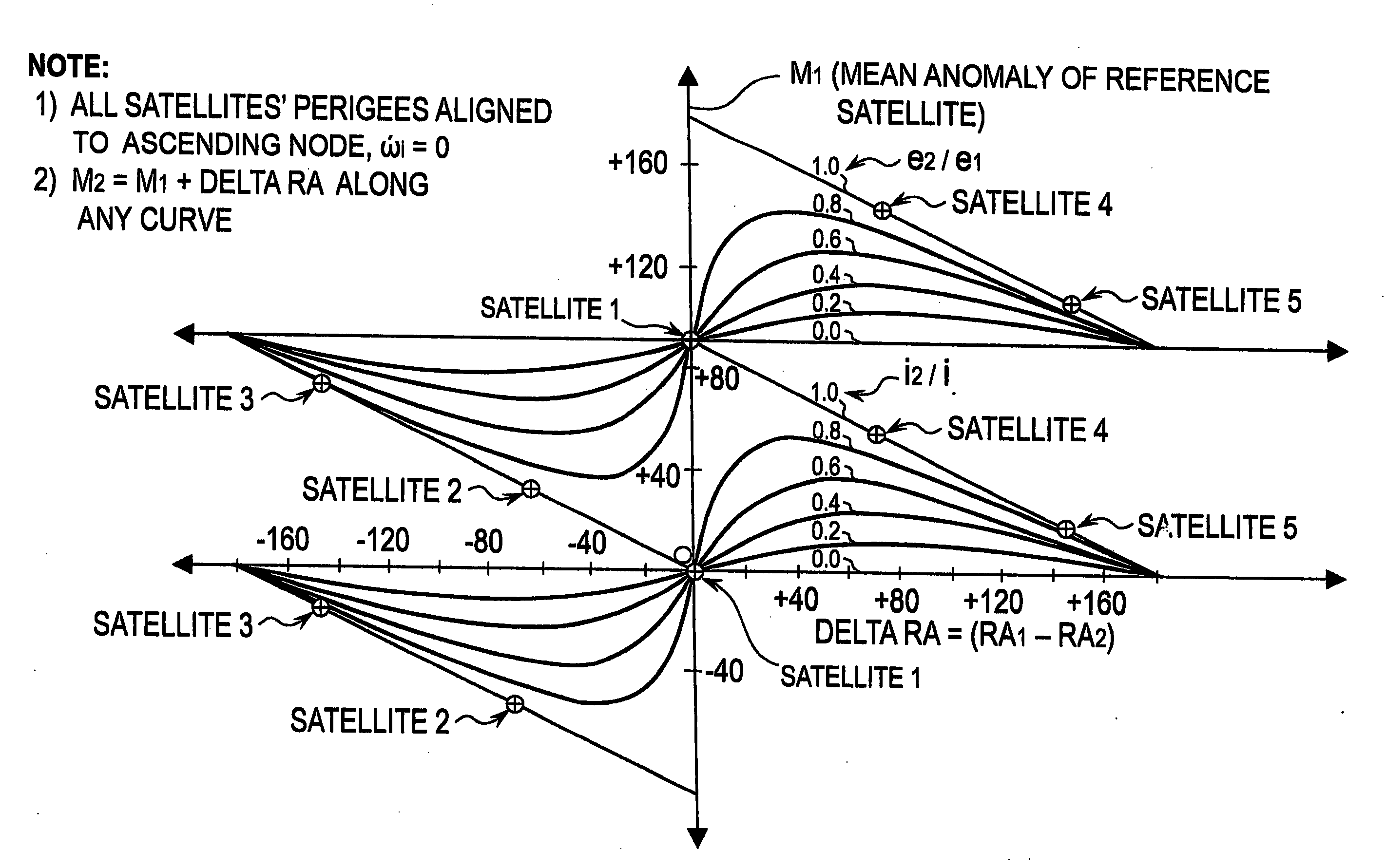
[0071]We next examine the loci where the reference satellite has its perigee aligned 90 deg ahead of the ascending node, i.e., w1=90 but all other satellites have their perigees aligned along the ascending node, i.e., delta w=90. These assumptions result in the following four solutions:

Identical Radii:

[0072]

(1) M2=Q+90, M1=M2−(delta RA+90),

(2) M2=Q+270, M1=M2−(delta RA+90)

Identical Latitude:

[0073]

(1) M1=Z−90, M2=M1+(delta RA+90),

(2) M1=Z+90, M2=M1+(delta RA+90)

[0074]FIGS. 5a &5b illustrate each of the four solutions as a family of curves with parameter (e2 / e1) or (i2 / i1). Note first that the “solid family of curves” defining the loci of all solutions where radii are equal have shifted to the left on the X axis by 90 deg, since delta w is equivalent to adding 90 deg to delta RA. Note second that the “dashed family of curves” defining the loci of all solutions where latitude is equal have shifted down on the Y axis by 90 deg, since perigee of the reference satellite has been moved for...

case c

[0075]We finally examine the loci where the reference satellite has its perigee aligned 180 deg ahead of the ascending node, i.e., w1=180 but all other satellites have their perigees aligned along the ascending node, i.e., delta w=180. These assumptions result in the following four solutions:

Identical Radii:

[0076]

(1) M2=Q+90, M1=M2−(delta RA+180),

(2) M2=Q+270, M1=M2−(delta RA+180)

Identical Latitude:

(1) M1=Z−180, M2=M1+(delta RA+180),

(2) M1=Z, M2=M1+(delta RA+180)

[0077]FIGS. 6a &6b illustrate each of the four solutions as a family of curves with parameter (e2 / e1) or (i2 / i1). Note that the “solid family of curves” defining the loci of all solutions where radii are equal have shifted to the left on the X axis by 180 deg (as expected), since once again delta w is equivalent to adding 180 deg to delta RA. Note also that the “dashed family of curves” defining the loci of all solutions where latitude is equal have shifted down on the Y axis by 180 deg from the w1=0 solution, yielding the s...


PUM


Abstract

A method of flying a constellation of inclined geosynchronous satellites at the same station longitude with specific spacing but without the possibility of collision and provides the basic equations defining the initial positions of satellites such that the satellites will continue to remain in synchronized positions relative to each other for a number of years with little or no north-south positioning. In preferred embodiments the number of satellites in the constellation is five or ten. Communication with the satellites in the constellation is provided with existing prior art tracking radio systems.

Description

CROSS REFERENCE TO RELATED APPLICATIONS[0001]This application is a continuation in part of Ser. No. 12 / 657,188, filed Jan. 14, 2010, which is incorporated herein by reference and claims the benefit of Provisional Patent Application 61 / 396,087 filed May 20, 2010.FIELD OF INVENTION[0002]The present invention relates to communication systems utilizing geostationary communication satellites and in particular to those systems when the satellite is in an inclined orbit.BACKGROUND OF THE INVENTION[0003]Typically geostationary satellites are maintained in an orbit position that is synchronized with the rotation of the earth so that the satellite appears to be in a stationary position above the surface of the earth. Transmit and received antennas on earth communicating with the satellite can therefore be maintained in a fixed position. To maintain the satellite in this geostationary position relative to the surface of the earth booster rockets must be fired periodically to correct the satell...

Claims


Application Information

Patent Timeline
Patent Type & Authority Applications(United States)
IPC IPC(8): B64G1/10
CPCB64G1/1007B64G1/24B64G1/1085B64G1/242
Inventor LIM, WAH L.SALVATORE, JEREMIAH
Owner LIM WAH L
Why Eureka
Try Eureka