
Smart Scoring And Filtering of User-Annotated Geocoded Datasets

a geocoded dataset and user-annotated technology, applied in the field of geocoded datasets display interfaces, can solve problems such as difficulty in obtaining data, lack of detail, and inconvenient us

Active Publication Date: 2015-06-18
GOOGLE LLC
View PDF3 Cites 1 Cited by
  • Summary
  • Abstract
  • Description
  • Claims
  • Application Information

AI Technical Summary

Benefits of technology

The present invention is a geographic information system and method that allows users to display and analyze user-generated data, such as videos, photos, and blogs, with geo-annotations. The system extracts useful information from the data and eliminates extraneous information. It also allows users to search for geo-annotations and metadata associated with the data. The system utilizes a scorer to determine the geographic level-of-detail for the data and a data storage system to organize the data. The technical effects of the invention include improved usability of geographic information systems and better processing of geocoded data.

Problems solved by technology

Nevertheless, it remains a challenge to process datasets of information to extract useful geocode information and to present the data in a usable interface.
For example, extracted data may not be particularly useful.
It may lack detail, and may therefore be of little value to a user.
In addition, the available information may be misleading.

Method used


Image

  • Smart Scoring And Filtering of User-Annotated Geocoded Datasets
  • Smart Scoring And Filtering of User-Annotated Geocoded Datasets
  • Smart Scoring And Filtering of User-Annotated Geocoded Datasets

Examples


Embodiment Construction

[0017]A preferred embodiment of the present invention is now described with reference to the figures, where like reference numbers indicate identical or functionally similar elements. Also in the figures, the leftmost digit of each reference number corresponds to the figure in which the reference number is first used. While specific configurations and arrangements are discussed, it should be understood that this is done for illustrative purposes only. A person skilled in the relevant art will recognize that other configurations and arrangements can be used without departing from the spirit and scope of the invention. It will be apparent to a person skilled in the relevant art that this invention can also be employed in a variety of other systems and application.

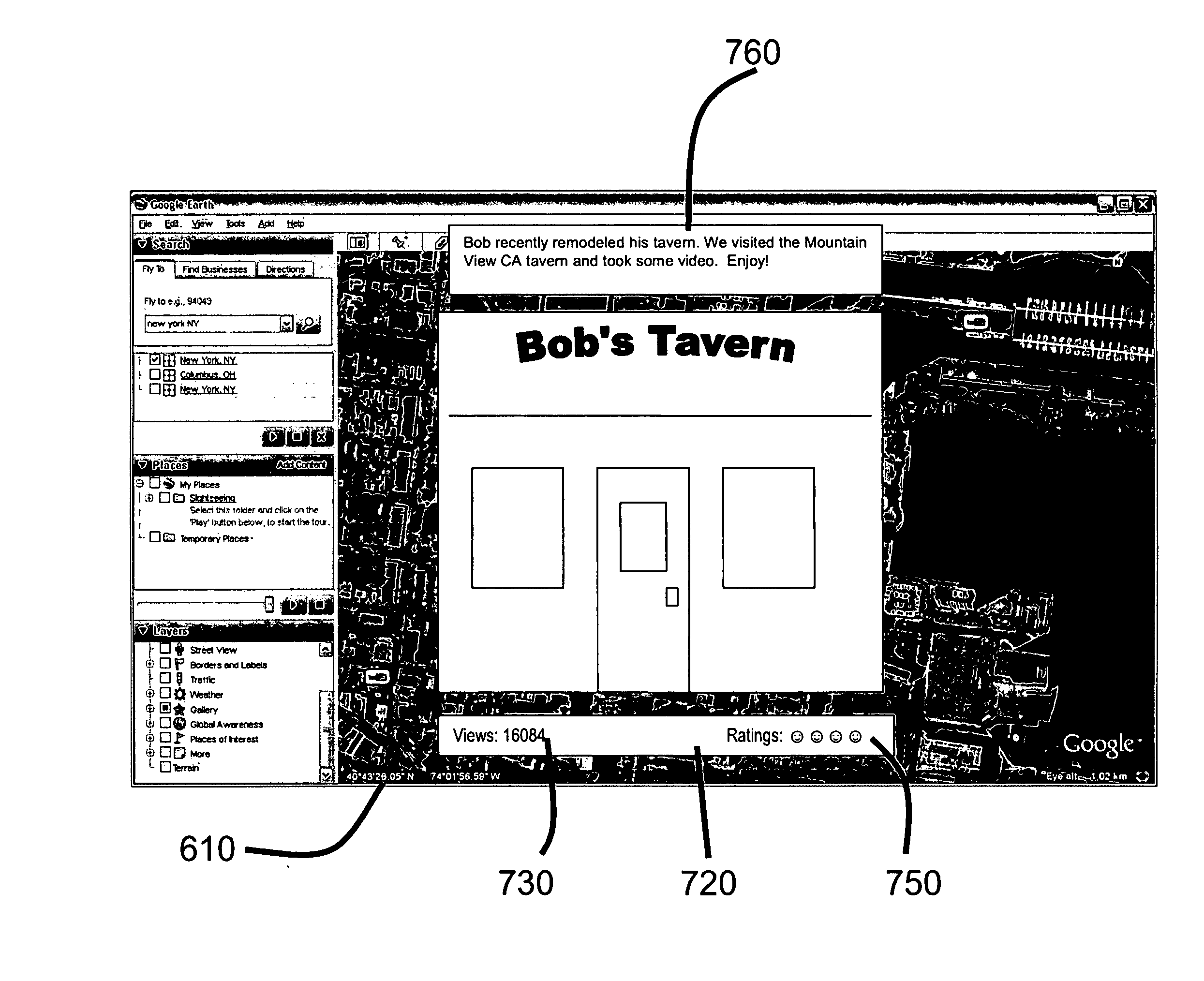
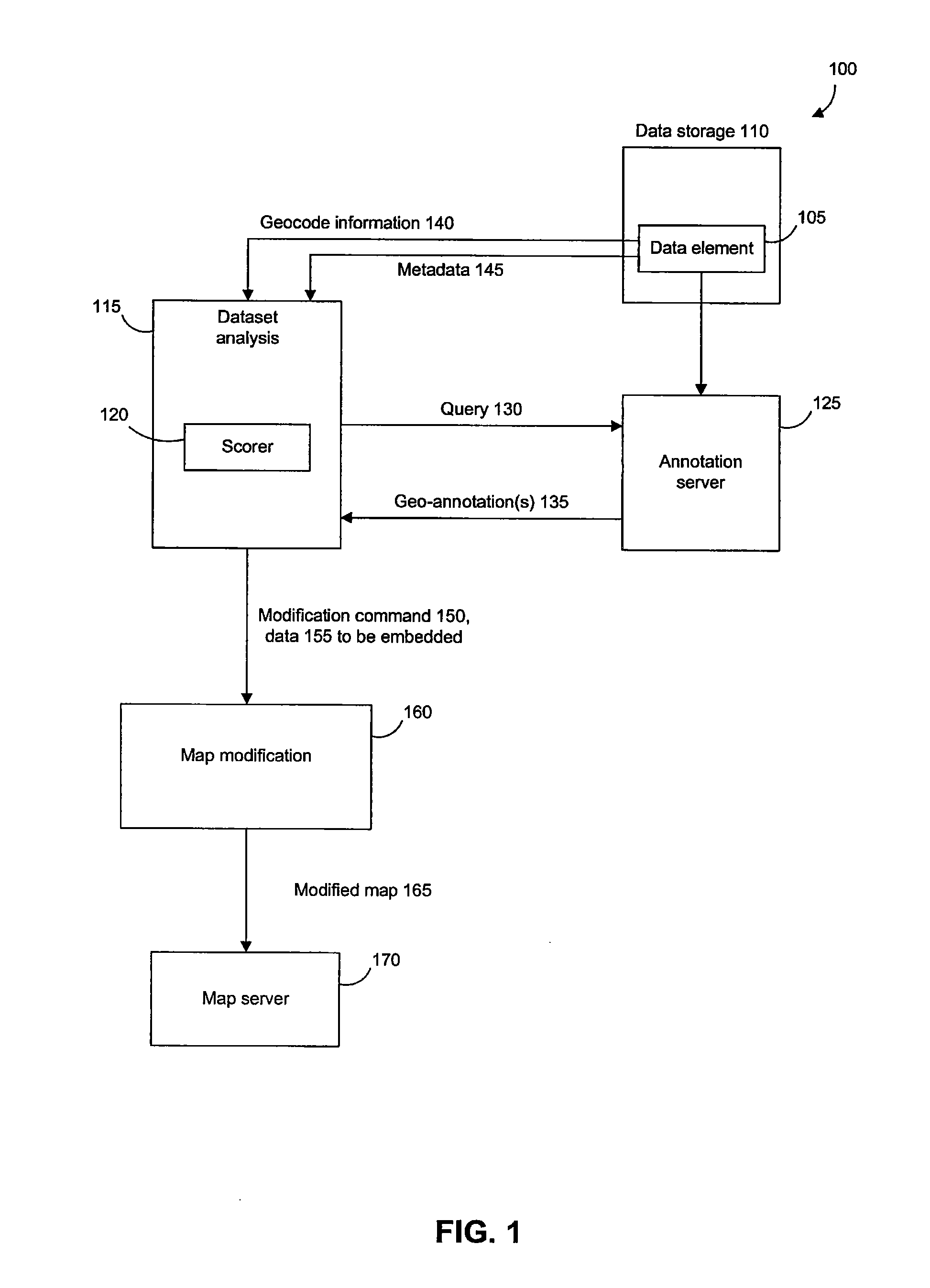
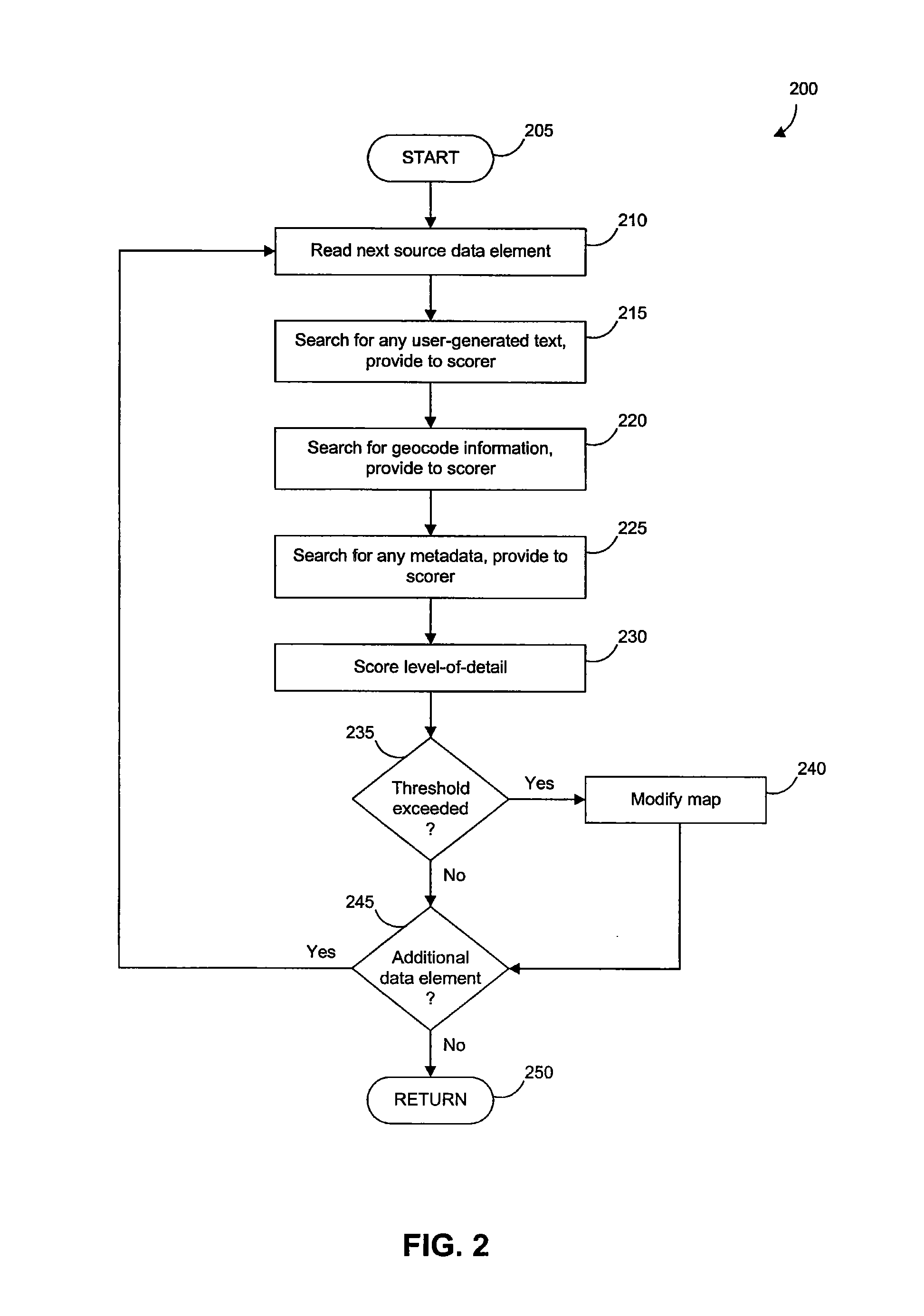
[0018]The following describes a geographic information system and method that facilitate the display of user-annotated datasets. The dataset, for example, can include elements such as user-generated videos, photos, blogs, etc...


PUM


Abstract

A geographic information system and method that facilitate the display of user-annotated datasets. The dataset can include data such as user-generated videos, photos, blogs, etc., and is processed to search for geo-annotations. The geo-annotations and other data signals are utilized by a scorer to determine a level-of-detail for the particular data. The level-of-detail provided by the scorer is utilized by the geographic information system to determine which data to display as a user navigates around a map.

Description

[0001]This application claims the benefit of U.S. Provisional Application No.[0002]60 / 960,737, filed on Oct. 11, 2007, which is incorporated herein by reference in its entirety.BACKGROUND OF THE INVENTION[0003]1. Field of the Invention[0004]The present invention relates to geographic information systems and interfaces for displaying geocoded datasets.[0005]2. Background Art[0006]Modern geographic information systems such as Google Earth enable the sophisticated display and analysis of geocoded data. Nevertheless, it remains a challenge to process datasets of information to extract useful geocode information and to present the data in a usable interface. For example, extracted data may not be particularly useful. It may lack detail, and may therefore be of little value to a user. In addition, the available information may be misleading. Geo-annotations, for example, may appear to be germane to the related geographical location, but may in fact be irrelevant. A reference to “freedom” ...

Claims


Application Information

Patent Timeline
Patent Type & Authority Applications(United States)
IPC IPC(8): G06F17/24G06F17/30
CPCG06F17/30663G06F17/241G06F16/29G06F40/169
Inventor CHARANIYA, AMINJONES, MICHAEL T.
Owner GOOGLE LLC
Learn More