Eureka AIR delivers breakthrough ideas for toughest innovation challenges, trusted by R&D personnel around the world.

Dynamically customized three dimensional geospatial visualization

Active Publication Date: 2016-10-13
GEOPOGO INC
View PDF16 Cites 22 Cited by
  • Summary
  • Abstract
  • Description
  • Claims
  • Application Information

AI Technical Summary

Benefits of technology

The invention is about a method and system for transmitting dynamically customized 3D rendering of geospatial data. The system determines the user's area of interest and customizes the GPS coordinated 3D point cloud data related to the location based on the user's area of interest. The server computer periodically determines the GPS coordinates of the user, and if updated point cloud data needs to be transmitted, the server transmits the data to the client computer. The client computer then receives the point cloud data, rends it to depict a 3D view of the location, and displays the information related to the user's area of interest. The user's area of interest can be determined based on the user's action, behavior, or preference. The point cloud data can be related to realistic or fantasized geographical location settings.

Problems solved by technology

However, such imagery is not unified and movement is restricted to the vantage point of the source of the two dimensional images.
This limits the viewer's freedom to move through and explore a given setting.
Moreover, conventional methods deprive the user of an enhanced experience of browsing through a virtual world that is based on realistic geographical features.

Method used


Image

  • Dynamically customized three dimensional geospatial visualization
  • Dynamically customized three dimensional geospatial visualization
  • Dynamically customized three dimensional geospatial visualization

Examples


Embodiment Construction

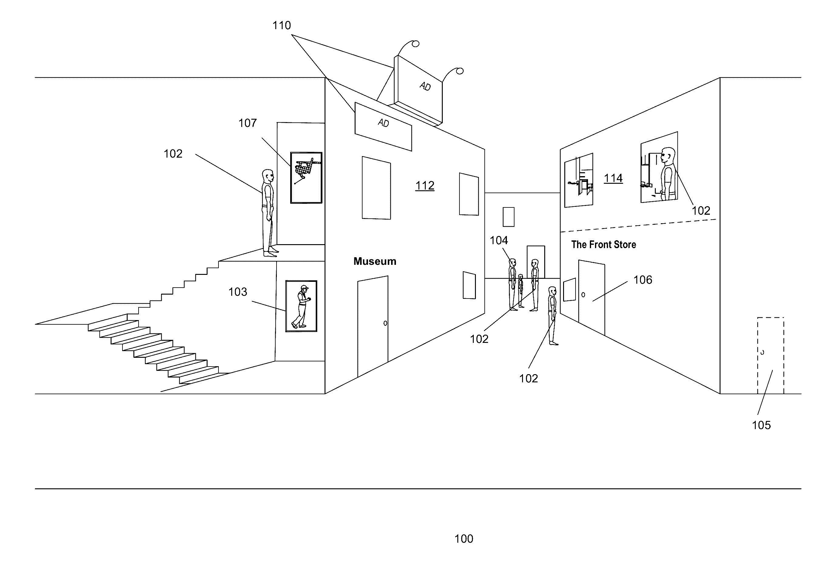
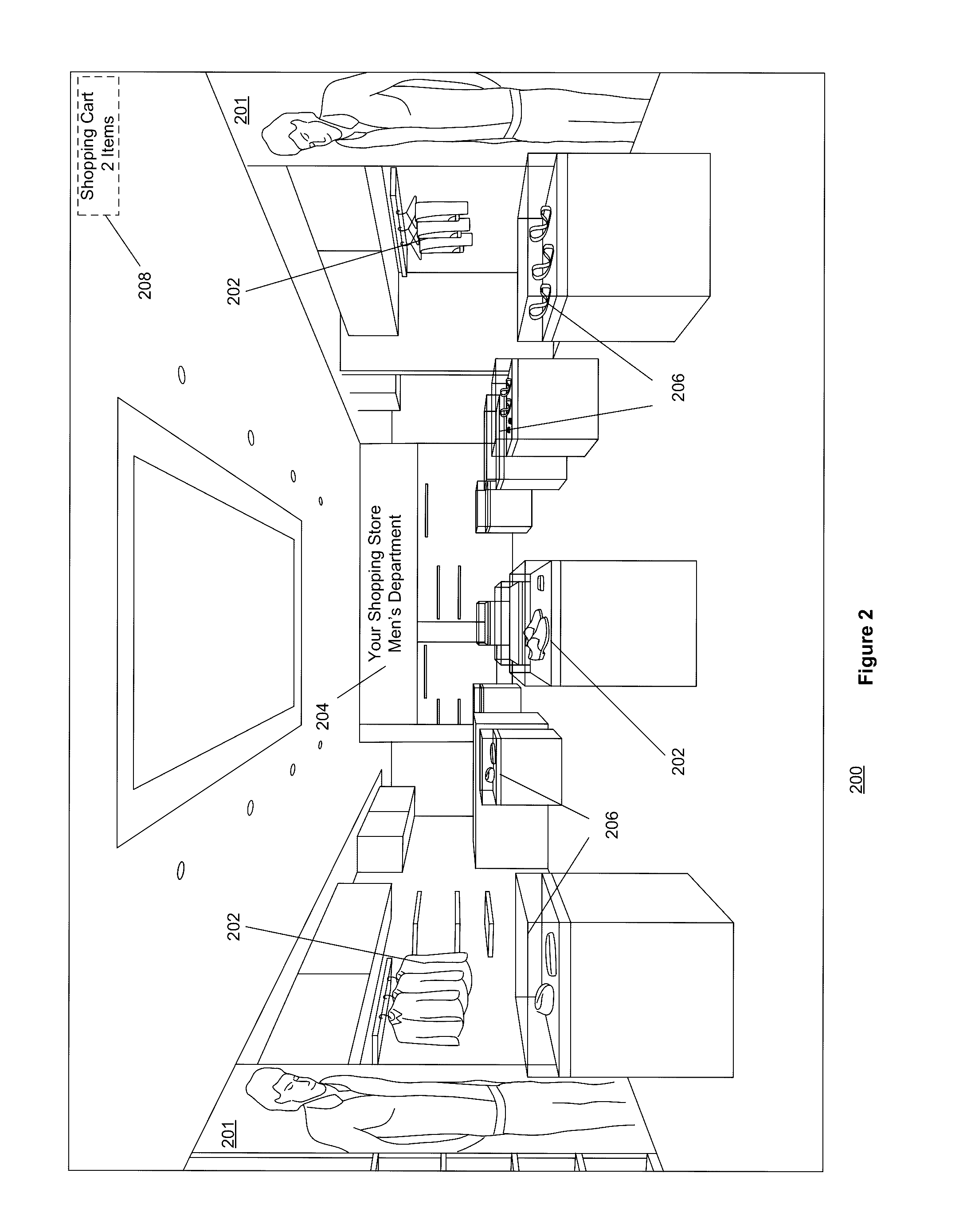
[0028]Various embodiments of three dimensional geospatial visualization techniques disclosed in Co-pending U.S. patent application Ser. No. 14 / 987,349, filed on Jan. 4, 2016, can be employed, in whole or in part, with the present invention. As a result, the above-identified disclosure is incorporated herein by reference in its entirety to the extent that such subject matter is not inconsistent herewith.

[0029]Various embodiments and aspects of the inventions will be described with reference to details discussed below, and the accompanying drawings will illustrate the various embodiments. The following description and drawings are illustrative of the invention and are not to be construed as limiting the invention. Numerous specific details are described to provide a thorough understanding of various embodiments of the present invention. However, in certain instances, well-known or conventional details are not described in order to provide a concise discussion of embodiments of the pre...


PUM


Abstract

Using various embodiments, methods, and systems for implementing a dynamically customized three dimensional geospatial visualization techniques in a point cloud are disclosed. In one embodiment, a user's current area of interest can be determined to generate a dynamically customized three dimensional geospatial setting. In one embodiment, the area of interests can be determined based on a user's actions, behavior, and / or preferences. The geospatial (exterior or interior) settings or the content displayed within the settings can be dynamically customized in real time for each user.

Description

CROSS REFERENCE TO RELATED APPLICATIONS[0001]The present application claims priority from U.S. Provisional Patent Application No. 62 / 144,193 filed on Apr. 7, 2015, under 35 U.S.C. 119(e), the contents of the above mentioned provisional patent application is incorporated herein by reference, for all purposes to the extent that such subject matter is not inconsistent herewith.FIELD OF THE INVENTION[0002]Embodiments of the present invention generally relate to the field of three dimensional visualization of geospatial data. More particularly, embodiments of the invention relate to a mechanism to present a unified indoor / outdoor representation of structures, buildings, and objects using geospatial data that can be dynamically customized for a user's convenience.BACKGROUND OF THE INVENTION[0003]Conventional methods simulate three-dimensional geospatial visualization techniques using two-dimensional imagery. Such conventional methods include joining multiple individual images, e.g., panor...

Claims


Application Information

Patent Timeline
IPC IPC(8): G06F3/0481G06T17/05G06T15/10H04L29/12H04L29/08
CPCG06F3/04815H04L61/609H04L67/18G06T2215/16G06T15/10G06T17/05H04L67/306G06F3/011G06T19/003H04L67/52H04L67/131G06Q30/00
Inventor ALPERT, DAVIDSORRENTO, GABRIELE
Owner GEOPOGO INC
Why Eureka
Eureka Blog
Learn More