Supercharge Your Innovation With Domain-Expert AI Agents!

Classifying entities in digital maps using discrete non-trace positioning data

Active Publication Date: 2017-11-23
MICROSOFT TECH LICENSING LLC
View PDF6 Cites 7 Cited by
  • Summary
  • Abstract
  • Description
  • Claims
  • Application Information

AI Technical Summary

Benefits of technology

The patent describes a technology that allows entities in digital maps to be identified based on discrete positioning data collected from devices like mobile phones. This is done by analyzing the positioning data in relation to tiles on a map. The technology uses a tile-based approach to classify entities in the map, which reduces the need for manual effort and allows for the discovery of new roads and changes in businesses without requiring physical resources. The technology can also detect changes in the map over time by analyzing GPS records and updating the map accordingly. Overall, the technology improves the efficiency and accuracy of identifying entities in digital maps.

Problems solved by technology

While sometimes taken for granted, a great deal of advanced technology and manual effort are required to construct, curate, and maintain maps over time.
However, it is difficult to keep up with road changes just by driving every street, in addition to being a time consuming and expensive endeavor.
Aerial imagery is utilized in other situations, but also has limits with respect to staying current and capturing the direction, speed, controls, and restrictions of a road.
Global Positioning System (GPS) traces have been used to overcome the challenges mentioned above, but come with limitations of their own.
For example, multiple GPS points are needed to build a given trace, which limits the anonymity of such traces.
The lack of anonymity influences users to limit their availability, which in turn reduces their effectiveness as a resource for inferring the presence roads and their details in a map.

Method used


Image

  • Classifying entities in digital maps using discrete non-trace positioning data
  • Classifying entities in digital maps using discrete non-trace positioning data
  • Classifying entities in digital maps using discrete non-trace positioning data

Examples


example 2

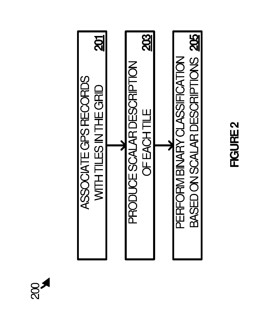
[0061]The method of Example 1 wherein the scalar description of each of the tiles in the area of interest comprises a feature vector having features and wherein producing the scalar description comprises: deriving the features from data included in the discrete positioning records; and constructing the feature vector from the features.

example 3

[0062]The method of Examples 1-2 wherein performing the binary classification of the tile comprises submitting the feature vector for the tile and other feature vectors for the other tiles as input to a binary classifier.

example 4

[0063]The method of Examples 1-3 wherein the other tiles comprise a subset of the tiles in the area that surround the tile in the grid.


PUM


Abstract

Systems, methods, and software are disclosed herein for enhancing entity classification operations for digital maps. In an implementation, an entity classification system associates tiles in a grid overlaying a map with discrete positioning records produced by devices operating in areas represented in the map. For each tile in an area of interest in the grid, the system produces a scalar description based on a subset of the discrete positioning records associated with the tile. The system then performs a binary classification of each tile as a type of entity (e.g. a road, business, or residence) based on the scalar description of the tile and the scalar descriptions of other tiles in the area of interest.

Description

TECHNICAL BACKGROUND[0001]Digital maps have become indispensable tools of modern life that allow people to quickly and easily navigate to their destination, find places of interest, and otherwise explore their surroundings. While sometimes taken for granted, a great deal of advanced technology and manual effort are required to construct, curate, and maintain maps over time.[0002]Specially equipped vehicles are utilized in some situations to travel the roads while recording street details. However, it is difficult to keep up with road changes just by driving every street, in addition to being a time consuming and expensive endeavor. Aerial imagery is utilized in other situations, but also has limits with respect to staying current and capturing the direction, speed, controls, and restrictions of a road.[0003]Global Positioning System (GPS) traces have been used to overcome the challenges mentioned above, but come with limitations of their own. For example, multiple GPS points are nee...

Claims


Application Information

Patent Timeline
IPC IPC(8): G01C21/32G01S19/13
CPCG01S19/13G01C21/32G06F16/29G01C21/3815G01C21/3881
Inventor RACZ, DAVID L.
Owner MICROSOFT TECH LICENSING LLC
Features
  • R&D
  • Intellectual Property
  • Life Sciences
  • Materials
  • Tech Scout
  • Unparalleled Data Quality
  • Higher Quality Content
  • 60% Fewer Hallucinations
Learn More