Displaying Visible Points of Interest with a Navigation System

a navigation system and visible point technology, applied in the field of trip navigation, can solve problems such as difficulty in providing meaningful navigation instructions to drivers

Active Publication Date: 2019-01-17
UBER TECH INC
View PDF13 Cites 6 Cited by
  • Summary
  • Abstract
  • Description
  • Claims
  • Application Information

AI Technical Summary

Benefits of technology

[0004]Examples described herein provide a computer-implemented method, steps stored on non-transitory computer-readable storage media, and computer systems including one or more computer processors for executing computer program instructions and a non-transitory computer readable storage medium storing instructions executable by the one or more processors. In one example, a method includes receiving location data from a user device and determining a road bin associated with the received location, wherein a road bin is a grouping of data related to a geographic region. The method further includes identifying a set of POIs that are visible to an observer from within the road bin with data stored in the road bin, determining, with a set of predetermined rules, a subset of the identified visible POIs for the user device to present to a user, and transmitting information about the subset of POIs to the user device.

Problems solved by technology

However, it can be difficult to provide meaningful navigation instructions to a driver if the mapping and routing systems do not have information about street names or if the driver is travelling through a region in which one or more streets do not have street names.

Method used


Image

  • Displaying Visible Points of Interest with a Navigation System
  • Displaying Visible Points of Interest with a Navigation System
  • Displaying Visible Points of Interest with a Navigation System

Examples


Embodiment Construction

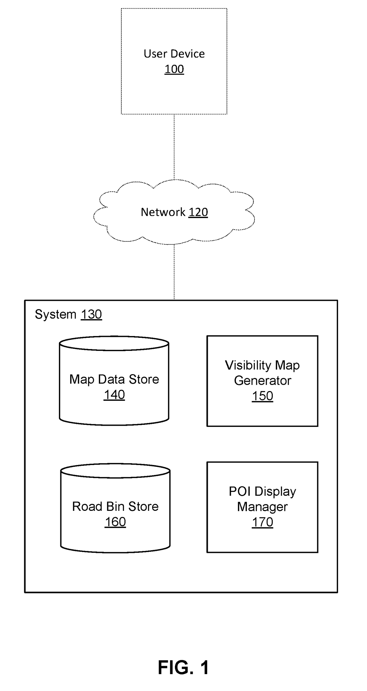
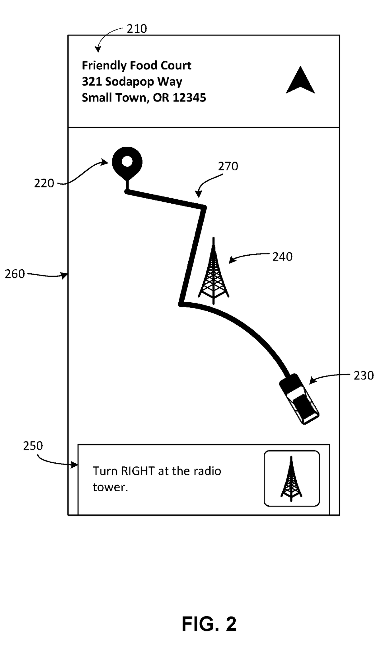
[0015]A system identifies points of interest (POIs), e.g., landmarks, to a user in a graphical user interface (GUI) according to a level of visibility of the POI from the user's location. For example, a navigation system can inform a user operating a vehicle (e.g., a car) to turn when a particular landmark becomes visible to the user from within the vehicle. Such information about POIs can be especially useful in regions where roads do not have names, or when the system does not have data about road names.

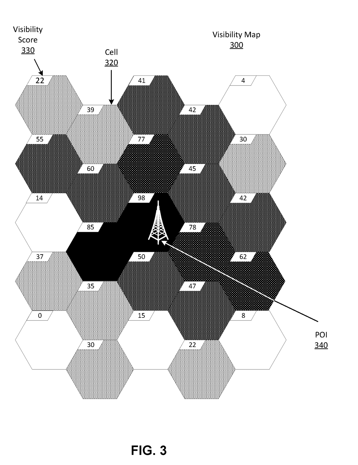
[0016]The system stores data about the visibility of individual POIs. For example, the system may store a visibility map of the visibility of each POI within a region. A visibility map may be in the format of a heat map or a choropleth map in that it associates regions of a geographic area with a value that represents the intensity, amount, or ease of visibility of a POI from each region. Such a visibility map may include data about locations from which a POI is visible, distances ...


PUM


Abstract

A system determines a set of POIs that are visible from a location. The system stores a visibility map for each POI. A visibility map includes data about locations or regions from which the associated POI is visible. The data may include information about how visible the POI is from different locations. The system divides a region into road bins (e.g., geofences a route passes through). Each road bin is associated with a set of POIs that are visible from locations within the road bin. When the system receives a request from a user device for information about visible POIs, the system determines a road bin that corresponds to the location of the user device, identifies POIs associated with the road bin, and transmits information about the set of POIs to the user device.

Description

BACKGROUNDField of Art[0001]This disclosure relates generally to trip navigation, and in particular to using landmarks to aid navigation.Description of Art[0002]Computerized systems provide a way of determining routes to destination addresses. The computerized systems can find user-specified addresses on a map, and provide routes between multiple addresses. Mapping and routing can have various applications, such as helping groups of people coordinate travel and directing drivers of vehicles to locations the drivers may be unfamiliar with. For example, mapping and routing systems may provide street names to a driver as the driver approaches turns along a route if the systems have data about the names of the streets along the route. However, it can be difficult to provide meaningful navigation instructions to a driver if the mapping and routing systems do not have information about street names or if the driver is travelling through a region in which one or more streets do not have st...

Claims


Application Information

Patent Timeline
Patent Type & Authority Applications(United States)
IPC IPC(8): G01C21/36G01C21/34
CPCG01C21/3682G01C21/3407G01C21/3644
Inventor MOORE, CHRISTOPHERSUH, JANICE J.KADLEC, BENJAMINTAO, CHRISTINE MISUYE
Owner UBER TECH INC
Why Eureka
Try Eureka