Method for training a neural convolutional network for determining a localization pose

Active Publication Date: 2021-04-29
ROBERT BOSCH GMBH
View PDF0 Cites 2 Cited by
  • Summary
  • Abstract
  • Description
  • Claims
  • Application Information

AI Technical Summary

Benefits of technology

The present invention describes a method for using aerial images to determine the position of a mobile platform by training a neural network with ground images and spatial context. This approach helps to correctly analyze and locate ambiguous features from ground images across a larger geographical area. A computer program is also provided to implement this method in different systems. The technical effect of this invention is improved accuracy and efficiency in positioning mobile platforms using aerial images.

Problems solved by technology

However, the use of such a highly resolving map entails economic disadvantages.
A localization in a very large geographical region poses a challenge with regard to an unambiguity of a determination of a pose.
In particular, for example, this is an integration of sequential information and a consideration of geometrical limitations, which may lead to a further output gain.
In addition, a constant query time for the pose determination results in this method, which is not the case in conventional, feature-based methods.
For example, no satisfactory scaling is achieved with a 3D-3D / 2D-3D feature matching in the case of large map sizes.

Method used


Image

  • Method for training a neural convolutional network for determining a localization pose

Examples


Embodiment Construction

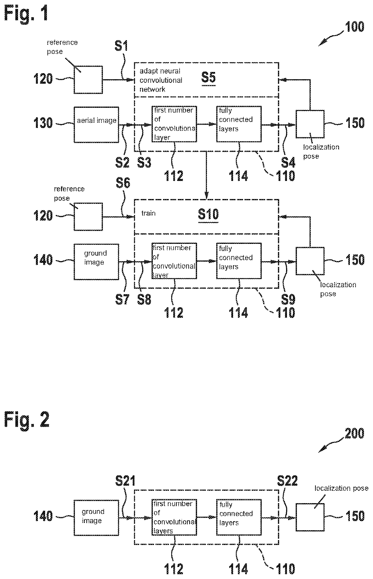
[0068]FIG. 1, using a data flow diagram, schematically shows a method 100 for training a neural convolutional network 110 for determining a localization pose (150) of a mobile platform using a ground image (140) with the aid of a neural convolutional network (110) in accordance with an example embodiment of the present invention. Method 100 has a first multitude of aerial image training cycles, each aerial image training cycle having the following steps: In a step S1 of an aerial image training cycle, a reference pose 120 of the mobile platform is provided. In a further step S2, an aerial image 130 of the environment of the mobile platform in reference pose 120 is provided. In a further step S3, aerial image 130 is used as an input signal of neural convolutional network 110. In another step S4, respective localization pose 150 is determined with the aid of an output signal of neural convolutional network 110. In an additional step S5, neural convolutional network 110 is adapted in o...


PUM


Abstract

A method for training a neural convolutional network for determining, with the aid of the neural convolutional network, a localization pose of a mobile platform using a ground image. Using a first multitude of aerial image training cycles, each aerial image training cycle includes: providing a reference pose of the mobile platform; and providing an aerial image of the environment of the mobile platform in the reference pose; using the aerial image as an input signal of the neural convolutional network; determining the respective localization pose with the aid of an output signal of the neural convolutional network; and adapting the neural convolutional network to minimize a deviation of the respective localization pose determined using the respective aerial image from the respective reference pose.

Description

CROSS REFERENCE[0001]The present application claims the benefit under 35 U.S.C. § 119 of German Patent Application No. 102019216379.3 filed on Oct. 24, 2019, which is expressly incorporated herein by reference in its entirety.FIELD[0002]The present invention relates to a method for training a neural convolutional network for determining a localization pose of a mobile platform with the aid of the neural convolutional network using a ground image.BACKGROUND INFORMATION[0003]A precise localization is a prerequisite for driving an at least partially automated platform such as autonomously operated vehicles.[0004]For a localization of such a mobile platform with the aid of ground images of the environment of this mobile platform, a number of different approaches have been pursued, which are typically based on features in relation to the environment of the mobile platform, these features then being allocated to a pose of the mobile platform via a high-resolution map.SUMMARY[0005]However,...

Claims


Application Information

Patent Timeline
IPC IPC(8): G06T7/70G01C11/06G05D1/02G06N3/08
CPCG06T7/70G01C11/06G05D1/0221G06N3/08G06T2207/10032G05D2201/0208G06T2207/20081G06T2207/30252G06T2207/30181G05D2201/0215G06T2207/20084G06T7/74G06T1/20G05D1/0246G05D1/0088G01C21/20G06T2207/30244
Inventor HASBERG, CARSTENSARANRITTICHAI, PIYAPATNASEER, TAYYAB
Owner ROBERT BOSCH GMBH
Why Eureka
Try Eureka