Method and system for minimizing storage and processing of ionospheric grid point correction information in a wireless communications device

Active Publication Date: 2006-04-18
GARMIN
View PDF15 Cites 28 Cited by
  • Summary
  • Abstract
  • Description
  • Claims
  • Application Information

AI Technical Summary

Benefits of technology

[0009]The present invention provides an improved method, system and device for minimizing storage and processing of ionospheric grid point correction data. In accordance with the present invention, a current position of a GPS receiver or other device is determined and a boundary is created based upon the position. Grid point correction data is then obtained only for correction points within the boundary. The collected correction points are used to correct the position initially determined by the GPS receiver.
[0010]In another aspect of the invention, a method in a GPS receiver for minimizing storage and processing of ionospheric grid point correction data is provided. According to the method, a current position of a GPS receiver is determined and a boundary is created based on the position. One or more bands and one or more blocks of grid point correction data are analyzed to determine if they are within the boundary. Then, a set of correction points is obtained that are derived from the grid point correction data from correction points within the one or more blocks and the one or more bands surrounding the current position.

Problems solved by technology

For example, GPS satellite signals are subject to errors caused by ionospheric disturbances and satellite orbit discrepancies.
Ionospheric and tropospheric refraction can slow satellite signals and cause carriers and codes to diverge.
Because ionospheric disturbances vary greatly from location to location, these errors are difficult to correct with civilian-type GPS receivers.
Many GPS receivers, including, for example, GPS receivers used in avionics applications and portable GPS receivers used for recreational and sport applications have limited memory and processing power and therefore cannot quickly and efficiently store and process all 2,592 ionospheric grid point correction elements.
Moreover, even for GPS receivers that have sufficient memory to store all the ionospheric grid point correction data, much of the memory required to do so is wasted because only the correction points within a certain distance of a GPS receiver's current location are relevant to the ionospheric conditions at that location.

Method used


Image

  • Method and system for minimizing storage and processing of ionospheric grid point correction information in a wireless communications device
  • Method and system for minimizing storage and processing of ionospheric grid point correction information in a wireless communications device
  • Method and system for minimizing storage and processing of ionospheric grid point correction information in a wireless communications device

Examples


Embodiment Construction

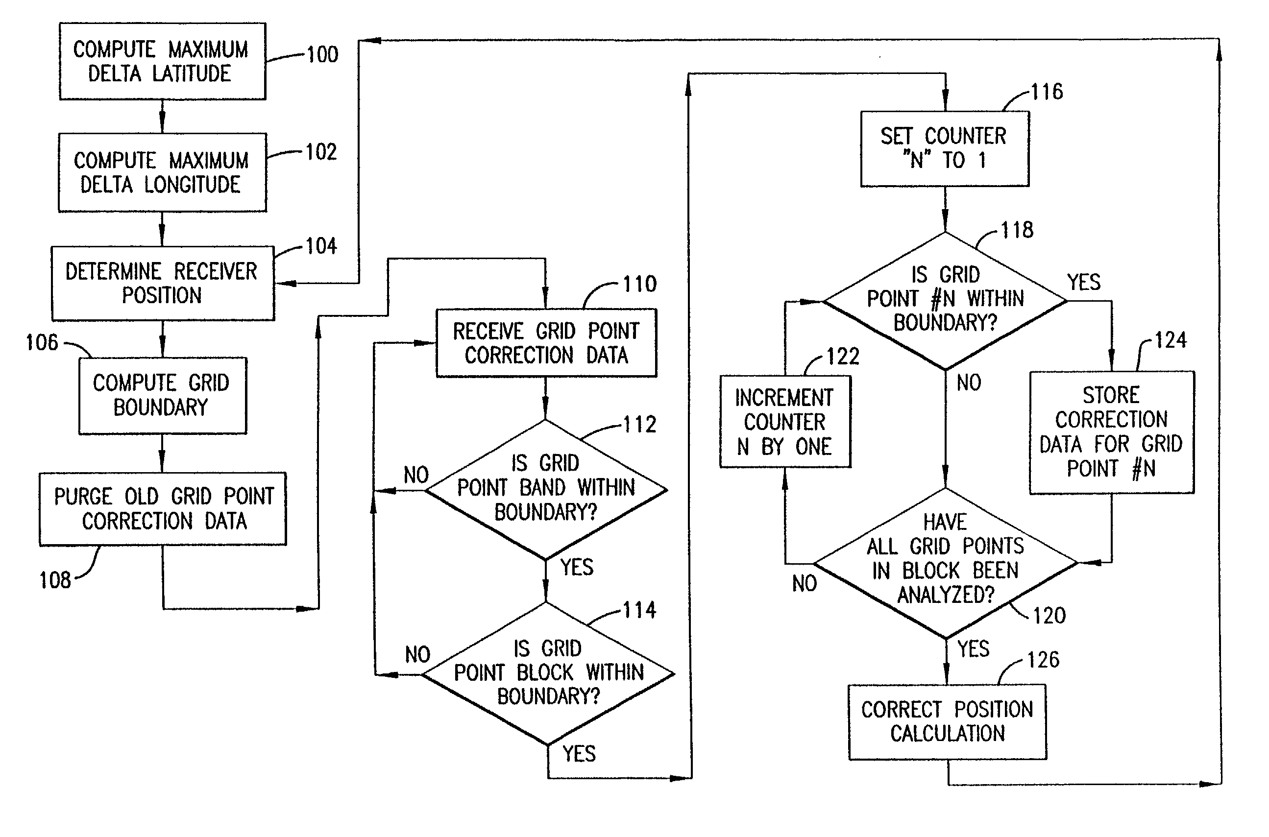
[0029]The present invention provides a method, system, and device for minimizing storage and processing of correction data transmitted from a Spaced Based Augmentation System (SBAS), such as WAAS, European Geostationary Navigation Overlay Service (EGNOS) or MSAS. A preferred embodiment of the present invention is directed to a method, system and device for minimizing storage and processing of ionospheric grid point corrections transmitted from WAAS satellites. It should be understood that the principles of the present invention may be applied to other types of corrections as well.

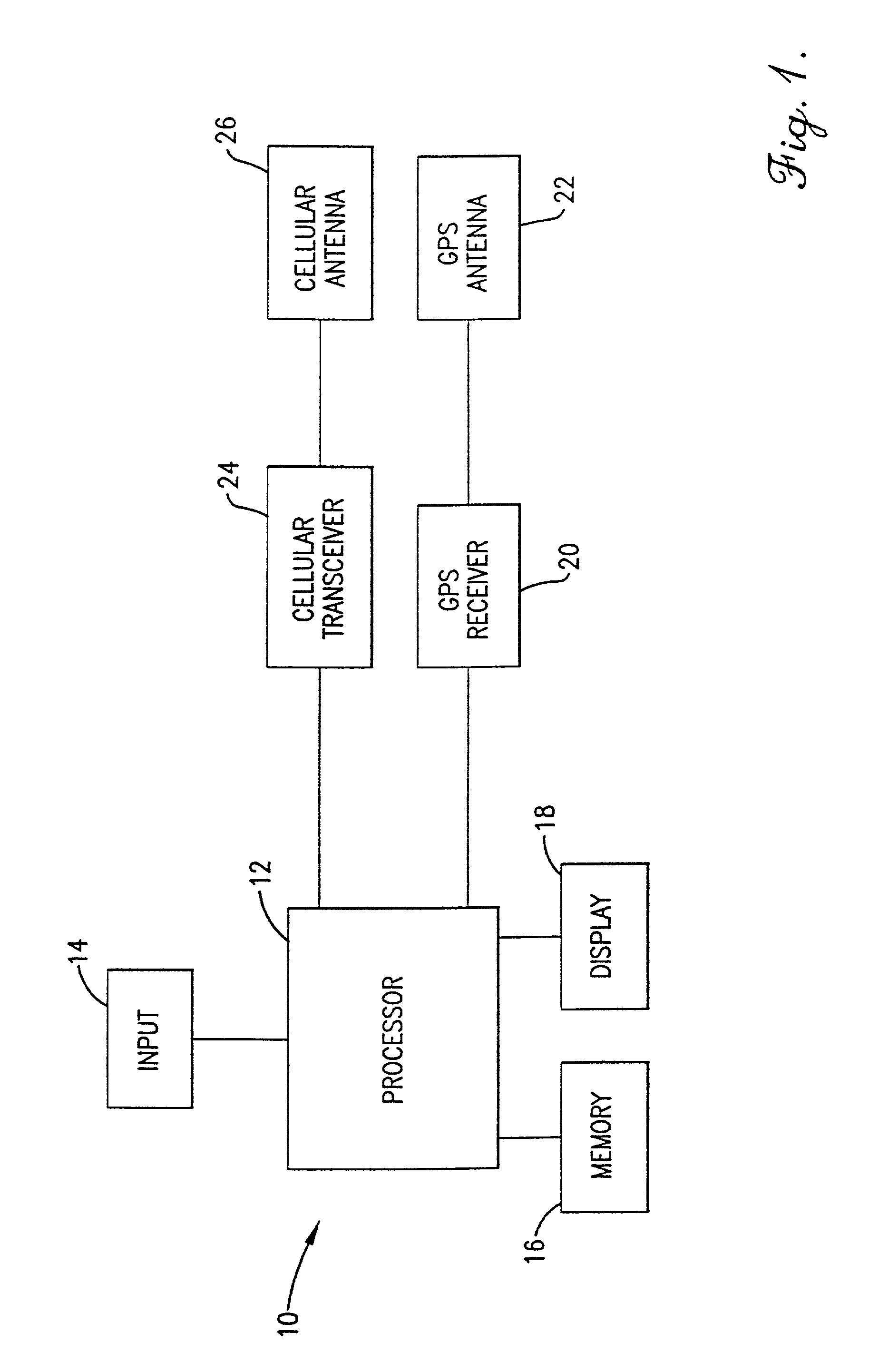
[0030]The present invention may be implemented with and / or incorporated into any global positioning system (GPS) device, including portable, handheld GPS navigation units, GPS-enabled wireless telephones, GPS-enabled personal digital assistants, GPS-enabled laptop computers, avionics equipment that incorporates GPS receivers, marine equipment that incorporates GPS receivers, etc. FIG. 1 illustrates an examp...


PUM


Abstract

A method and system are provided for minimizing storage and processing of ionospheric grid point corrections transmitted from WAAS satellites in a global positioning system. Based upon a current location, the system creates a boundary around the current location and collects ionospheric grid point corrections within the boundary. The collected correction points are used to correct the position initially determined by a global positioning system.

Description

[0001]This application is related to U.S. application Ser. No. 09 / 969,698, filed Oct. 1, 2001, now U.S. Pat. No. 6,552,680.STATEMENT REGARDING FEDERALLY SPONSORED RESEARCH OR DEVELOPMENT[0002]Not Applicable.FIELD OF THE INVENTION[0003]The present invention relates generally to a method, system and device for minimizing storage and processing of ionospheric grid point corrections transmitted from WAAS satellites and, more particularly, to such a method, system, and device that utilizes GPS location data and WAAS ionospheric grid point correction data to determine an optimal number of elements in a correction array utilizing a table-driven method for minimizing the number of ionospheric grid point corrections collected from the WAAS satellites.BACKGROUND OF THE INVENTION[0004]The Global Positioning System (GPS) is a worldwide radio-navigation system formed from a constellation of 24 satellites and corresponding ground stations. Each satellite continually broadcasts its location in spa...

Claims


Application Information

Patent Timeline
IPC IPC(8): H04Q7/20
CPCG01S19/07G01S19/41G01S19/40G01S19/074
Inventor BARBER, CLAYTONPEMBLE, CLIFF
Owner GARMIN
Why Eureka
Try Eureka