Digital map position information compressing method and device

a technology of position information and digital map, applied in the direction of maps/plans/charts, navigation instruments, instruments, etc., can solve the problems of erroneous matching on the receiving side, requiring tremendous social costs for maintenance, and not being able to eliminate dissociation completely, so as to achieve accurate reproduction of original shape

Inactive Publication Date: 2008-03-04
PANASONIC CORP
View PDF6 Cites 44 Cited by
  • Summary
  • Abstract
  • Description
  • Claims
  • Application Information

AI Technical Summary

Benefits of technology

[0034]The invention was made to solve these problems and an object thereof is to provide a method for compressing positional information on a digital map which can produce compressed data which are data representing positional information such as a road on the digital map and which can accurately reproduce an original shape in a small volume of data.
[0036]On a receiving side to which the compressed data are transmitted, a shape can be reproduced which most approximates to the original shape of the vector. In addition, a longer resampling length can be taken without exceeding a permissible error that has been determined in advance, thereby making it possible to enhance the compression coefficient of the transmitted data.
[0042]Thus, the angle resolution and the resampling length are caused to interlock with each other, so that in the event that the resampling length is long, the angle resolution is reduced, whereas in the event that the resampling length is short, the resampling length is increased, whereby positional information such as a road can transmitted accurately in a small volume of data.
[0046]By doing this, it is possible to avoid a state in which an error that is produced by the quantization has an effect on later orientations, whereby a reproduced shape can be prevented from being caused to largely deviate from the original shape.

Problems solved by technology

However, node numbers and link numbers defined for the road network need to be renumbered with new numbers as new roads are built or the existing roads are rerouted, and since digital map data produced by respective map manufacturers also need to be renewed in association with the renumbering of link numbers and node numbers, the methods using the node numbers and link numbers require tremendous social costs for maintenance.
This is because in the event that the resampling is performed on a road which is largely curved using the distance which is long, sampling points cannot be disposed at positions indicating the characteristic shape of the road, whereby the occurrence of erroneous matching on the receiving side becomes highly possible.
Moreover, even in the event that the resampling distance is set as short as possible, it is theoretically not possible to eliminate the dissociation completely.
In the event that a large angle resolution δ is set, however, the quantization error becomes larger, the occurrence of erroneous matching on the receiving side becomes highly possible.
This zigzag phenomenon prevents the accurate transmission of the road shape to the receiving side and reduces the compression coefficient of data.③ When the shape of a road is represented by the deviation angles of sampling points or deviation angle estimated difference values for transmission, in the event that the deviation angles indicating the positions of the sampling points or deviation angle estimated difference values are quantized after the rectilinear shape of the road has been resampled, since an error produced by the quantization has an effect on later orientations, there may occur a case where a shape that is reproduced on the receiving side largely deviates from the original shape.

Method used


Image

  • Digital map position information compressing method and device
  • Digital map position information compressing method and device
  • Digital map position information compressing method and device

Examples


first embodiment

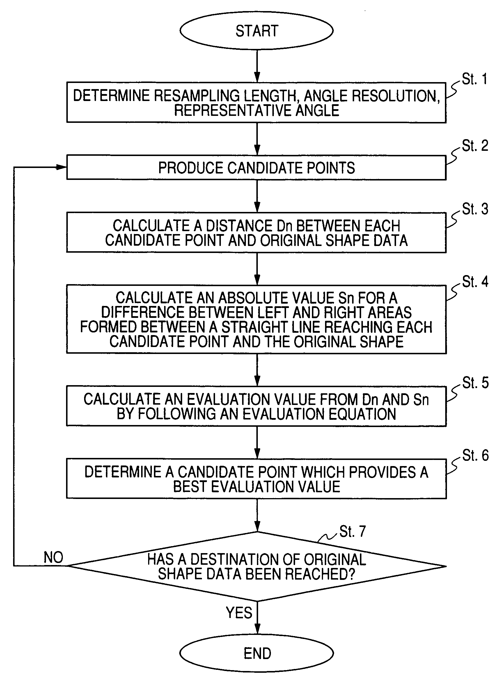
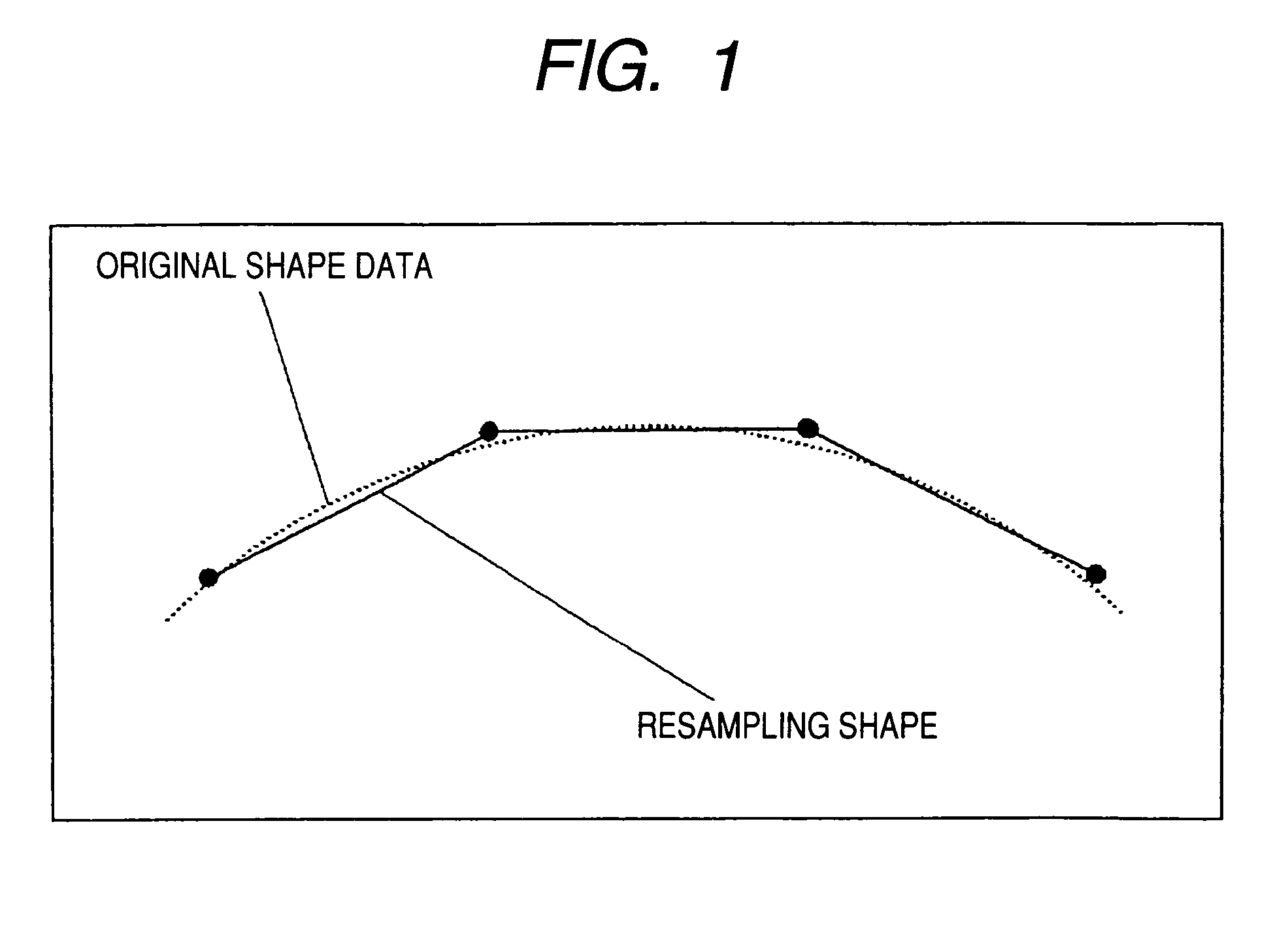
[0093]In a resampling method according to a first embodiment of the invention, sampling points are set by paying attention to areas between a straight line which links between the sampling points and an original shape.

[0094]In resampling the shape of a road, an equidistance resampling is carried out on an object road after a resampling length L and an angle resolution (namely, a quantization unit for representing the position data of a sampling point in terms of angle) δ are determined.

[0095]The resampling length L is set short when a curved road having a large curvature or a road in a mountainous area where there are many such curved roads is the object of resampling and is set long when a rectilinear road having a small curvature or a road in an urban area where there are many such rectilinear roads is the object of resampling. For example, as shown in FIG. 4, a resampling length L1 for equidistance resampling a segment of the shape of a road which has a small curvature is set lon...

second embodiment

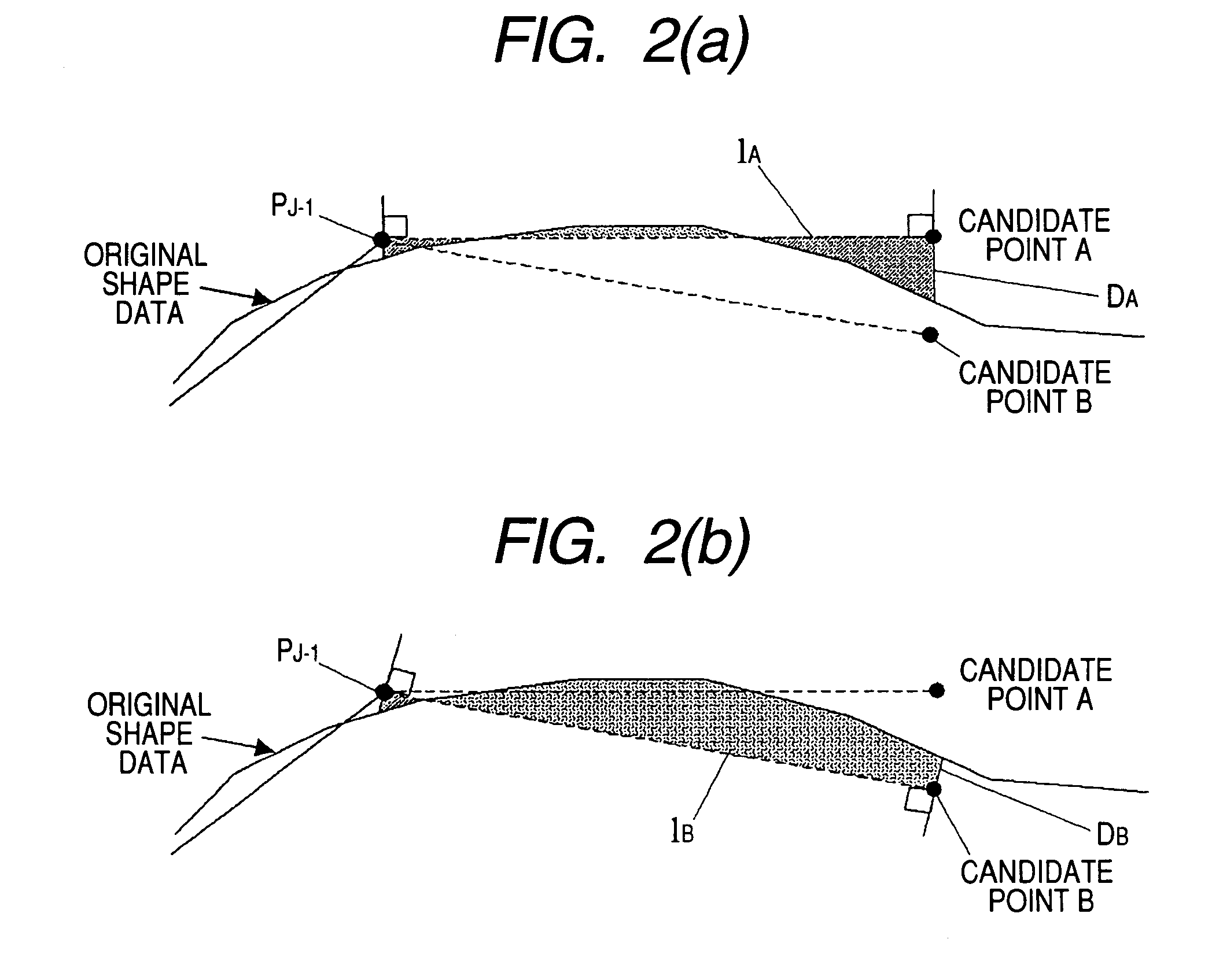
[0113]In a resampling method according to a second embodiment of the invention, in setting sampling points, instead of the areas, the length of line segments of an original shape which are located to the left and right of a resampling shape is considered.

[0114]In this resampling method, a procedure followed until candidate points for a sampling point are set remains the same as that of the first embodiment. When a plurality of candidate points have been set completely, as shown in FIG. 7, a sampling point is selected from the candidate points so set in consideration of distances DA, DB from the candidate points to the shape of a road (original shape data), as well as the length of line segments of the original shape which are divided to the left and right thereof by straight lines lA, lB.

[0115]As this occurs, the following equation (2) is used as an evaluation equation, and the candidate point which provides a smallest evaluation value is adopted as a sampling point PJ.

Evaluation Va...

third embodiment

[0126]In a resampling method according to a third embodiment of the invention, sampling points are set in consideration of a maximum error between a resampling shape and an original shape.

[0127]In this resampling method, a procedure followed until candidate points for a sampling point are set remains the same as that of the first embodiment. When a plurality of candidate points have been set completely, as shown in FIG. 9, a sampling point is selected from the candidate points so set in consideration of distances DA, DB from the candidate points to the shape of a road (original shape data), as well as the balance between maximum errors on the left and right of straight lines lA, lB (namely, maximum distances from the lines lA, lB to the shape data).

[0128]As this occurs, the following equation (3) is used as an evaluation equation, and the candidate point which provides a smallest evaluation value is adopted as a sampling point PJ.

Evaluation Value of Candidate Point n=αDn+β(|Enr−Enl|...


PUM


Abstract

The present invention provides a method and apparatus for compressing data of position information such as a road on a digital map in order to realize an accurate transmission of the position information in a small volume of data. A shape vector of an object road segment is resampled, and as this occurs, a sampling point is represented by quantized angle information. By selecting preferably the sampling point and an angle resolution of the quantized angle information, an error in position information can be reduced. For example, in a method for compressing position information by setting appropriately an angle resolution δ which constitutes a quantization unit of an angle, the angle resolution is set according the length of a resampling length L which regulates an interval of resampling, a road shape contained in a digital map is divided into one or a plurality of segments, road shapes in the segments are resampled by a constant resampling length L, and the position of the road shapes is represented by a data string of quantized angle information indicating the position of a sampling point, and data of the data string are variable length coded for transmission. By making the angle resolution δ and the resampling length L interlock with each other, the angle resolution is made small when the resampling length is long, whereas when the resampling length is short, the angle resolution is increased, whereby position information such as road can be transmitted accurately in a small volume of data.

Description

TECHNICAL FIELD [0001]The present invention relates to a method for compressing data of position information such roads on a digital map and an apparatus for implementing the method, and more particularly to a method and apparatus for transmitting a position accurately in a small volume of data.BACKGROUND ART [0002]Conventionally, in VICS (a road traffic information communication system), there has been a service of providing road traffic information indicating road segments where traffic jams are occurring or traveling time to vehicular navigation systems which have digital map databases installed therein through FM multiplex broadcasting or beacons. The vehicular navigation system receives the road traffic information to display a colored traffic-jam occurring road segment on a map displayed on the screen or to calculate a required time to a goal point for display.[0003]Thus, when road traffic information is provided, the position information on a road on the digital map needs to ...

Claims


Application Information

Patent Timeline
Patent Type & Authority Patents(United States)
IPC IPC(8): G01C21/30G01C21/32G09B29/00
CPCG01C21/32G01C21/3844G01C21/3819G01C21/3837
Inventor ADACHI, SHINYA
Owner PANASONIC CORP
Why Eureka
Try Eureka