Information retrieval system and method employing spatially selective features

a technology of information retrieval and spatial selection, applied in the field of information retrieval systems, can solve the problems of inability to achieve high-performance spatial search and retrieval capabilities of the internet, inability to find local content on the internet today, and inconvenient use, so as to remove the barriers to local content quickly and easily. , the effect of fast results

Active Publication Date: 2010-04-27
R2 SOLUTIONS
View PDF75 Cites 89 Cited by
  • Summary
  • Abstract
  • Description
  • Claims
  • Application Information

AI Technical Summary

Benefits of technology

[0018]The invention removes the barriers to finding local content quickly and easily. The invention solves the problem of requiring specific postal code or other positional information in order to conduct a search for local content by providing simple ‘point and click’ entry to begin a search anywhere in the World. The invention provides scalability and reliability, delivering comprehensive, targeted and customizable geo-coded local content, based on a user's actual or preferred location anywhere in the World, to any wired or wireless Internet device.

Problems solved by technology

Although location is a fundamental, unifying principle humans use to organize their “spatial awareness” of the world, the Internet has failed to deliver high performance spatial search and retrieval capabilities.
However, these services offer limited geographic scope and focus mainly on large metropolitan areas.
Quickly and easily finding local content on the Internet today is a laborious, convoluted, and inconsistent experience.
This inhibits a user in performing ‘real-world’ searches where one might not know an address or postal code.
A system for finding local content at any point within an international geographic extent has not been possible.
Current Internet mapping and local search capabilities are limited to static data, and are restricted to a delimited geographic area, such as a country, and do not provide an optimal geo-location search range for each record.
The problem is that the resulting size of the search catalogues often requires time-consuming scanning by users through a myriad of categories and / or a large amount of irrelevant results.
Some commercially available database management systems (DBMS) currently include basic spatial data management capabilities, providing limited support to location services.
Although many GIS's rely on DBMS's for this purpose, they are not competitive in terms of performance; flexibility, and scalability without direct access to a robust GIS at their foundation.
However to date, mapping on the Internet has been mainly a cartographic exercise, with minimal capability for true information searching and adding of new content.
However, most desktop mapping systems have limited data management, spatial analysis, or customization capabilities.
These systems feature few rules to specify how components can, or should be, assembled and include very, limited analytical capabilities.
Although some CAD systems have been extended to support maps, they typically have limited utility for managing and analyzing large geographic databases.

Method used


Image

  • Information retrieval system and method employing spatially selective features
  • Information retrieval system and method employing spatially selective features
  • Information retrieval system and method employing spatially selective features

Examples


Embodiment Construction

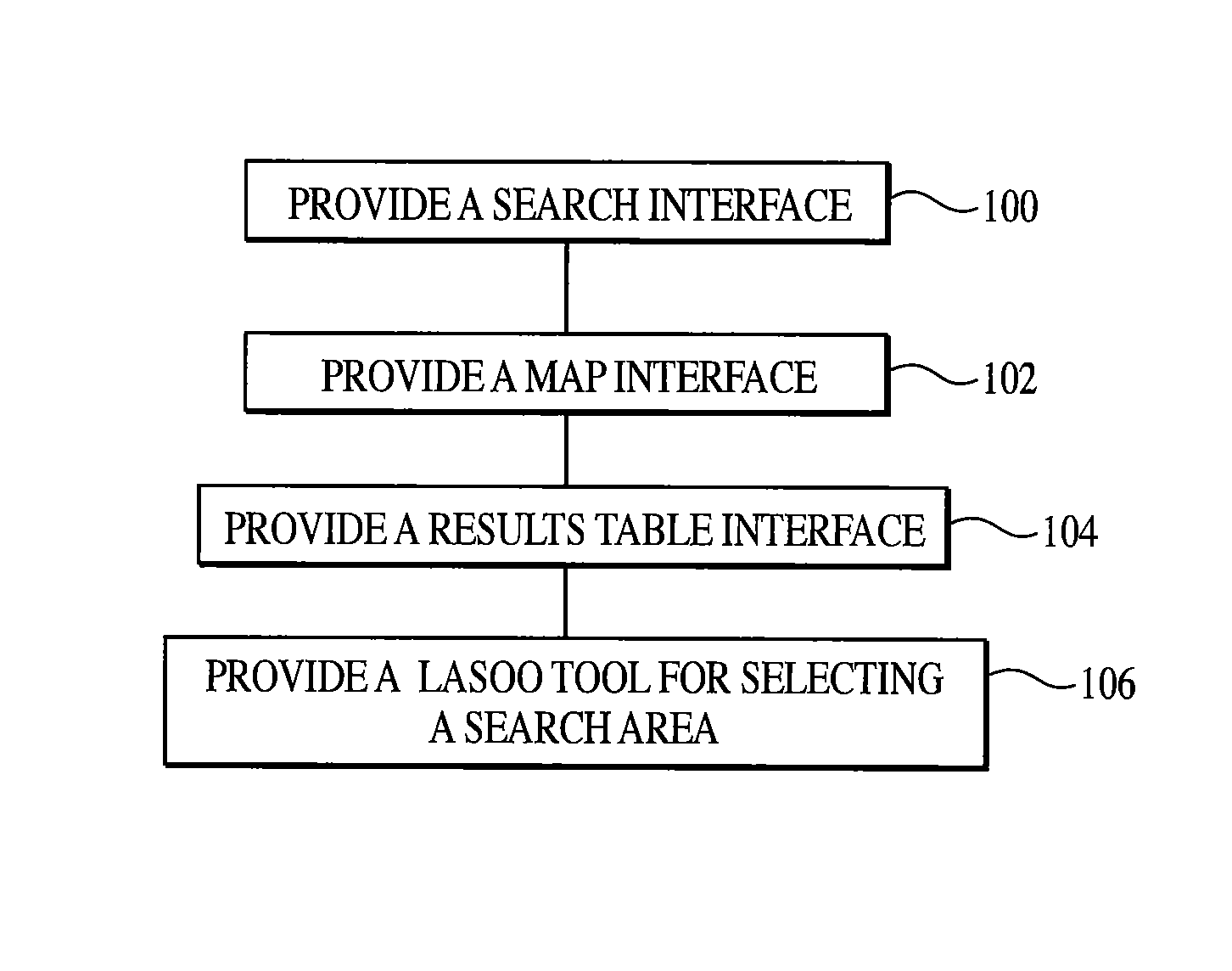
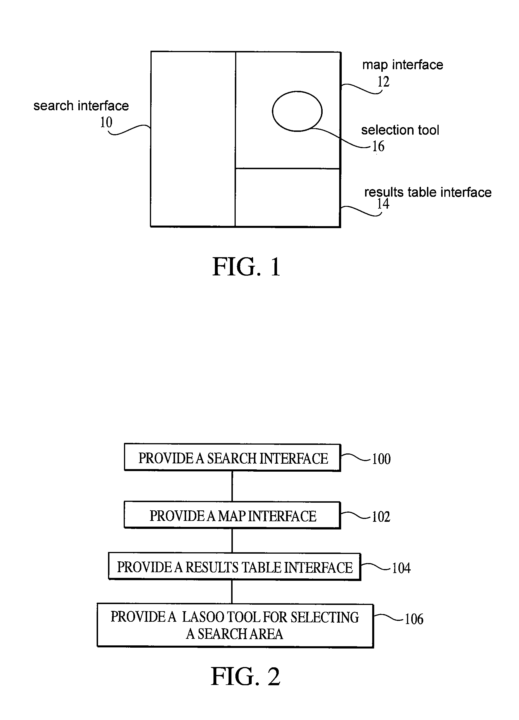
[0028]The present invention is directed to an information retrieval system and method employing spatially selective features. As illustrated in FIG. 1, the system includes a search interface 10, a map interface 12, a results table interface 14, and a selection tool 16 for selecting a search area. As illustrated in FIG. 2, the method includes the steps of providing a search interface 100, providing a map interface 102, providing a results table interface 104, and providing a selection tool 106 for selecting a search area.

Search Interface

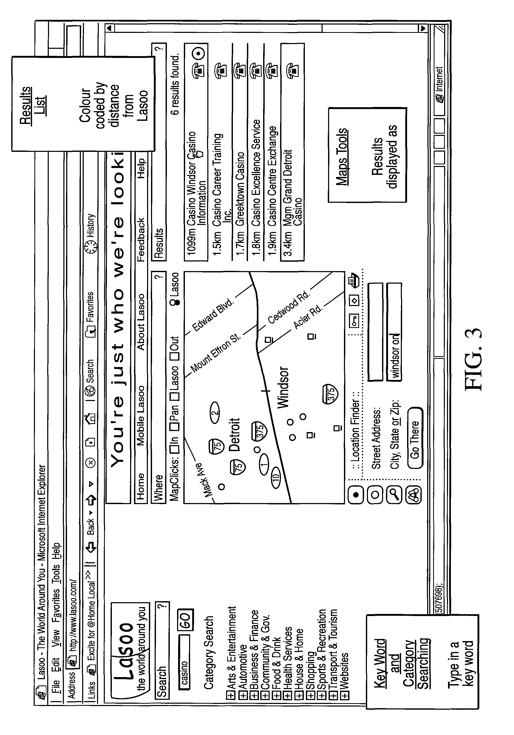
[0029]Embodiments of the Search Interface 10 include a Polygon Search Module (PSM), an Internet Database Link Control Module (IDLCM), an Auto Range Determination Module (ARDM), Extended Range Record Module (ERRM) and a Dynamic Filter (DF). As will be described below, various embodiments include various combinations of these modules to provide particular functionality.

[0030]The Polygon Search Module (PSM) enables the definition and storage of any geo-s...


PUM


Abstract

A geo-coded database stores advertiser records which include location information. Received search requests are matched with database records based on location information in the search requests and the record location information. In this manner, a user can search for information on a local basis and receive only the most relevant local search results.

Description

CROSS REFERENCE TO RELATED APPLICATIONS[0001]This application claims priority of PCT application number PCT / CA02 / 00144, having a priority date of Feb. 11, 2002, which claims priority of Canadian patent number 2,335,445, having a priority date of Feb. 9, 2001, which applications are incorporated herein in their entirety by this reference.BACKGROUND[0002]The present invention relates generally to information retrieval systems, and more particularly to an information retrieval system and method employing spatially selective features.[0003]Although location is a fundamental, unifying principle humans use to organize their “spatial awareness” of the world, the Internet has failed to deliver high performance spatial search and retrieval capabilities.[0004]Traditional means of finding local content have included reading the local newspapers, searching telephone yellow page directories, listening to the radio, spotting billboards, and seeing local TV announcements or advertising. On the Int...

Claims


Application Information

Patent Timeline
Patent Type & Authority Patents(United States)
IPC IPC(8): G06F7/00G06F17/30G06Q30/02
CPCG06F17/30241G06Q30/02G06F17/3087G06F16/29G06F16/9537Y10S707/99933
Inventor LEISHMAN, PETERFORTH, PETERSTEWART, JOHN
Owner R2 SOLUTIONS
Why Eureka
Try Eureka