Supercharge Your Innovation With Domain-Expert AI Agents!

Geospatial and image data collection system including image sensor for capturing 3D geospatial data and 2D image data and related methods

a geospatial and image data and image sensor technology, applied in the field of data collection, can solve the problems of high hardware and software costs of system production and the inability to use register techniques

Active Publication Date: 2015-08-25
HARRIS CORP
View PDF11 Cites 2 Cited by
  • Summary
  • Abstract
  • Description
  • Claims
  • Application Information

AI Technical Summary

Problems solved by technology

Such image registration techniques can be hardware intensive, and thus the production of systems using them can be costly.

Method used


Image

  • Geospatial and image data collection system including image sensor for capturing 3D geospatial data and 2D image data and related methods
  • Geospatial and image data collection system including image sensor for capturing 3D geospatial data and 2D image data and related methods
  • Geospatial and image data collection system including image sensor for capturing 3D geospatial data and 2D image data and related methods

Examples


Embodiment Construction

[0018]The present invention will now be described more fully hereinafter with reference to the accompanying drawings, in which preferred embodiments of the invention are shown. This invention may, however, be embodied in many different forms and should not be construed as limited to the embodiments set forth herein. Rather, these embodiments are provided so that this disclosure will be thorough and complete, and will fully convey the scope of the invention to those skilled in the art.

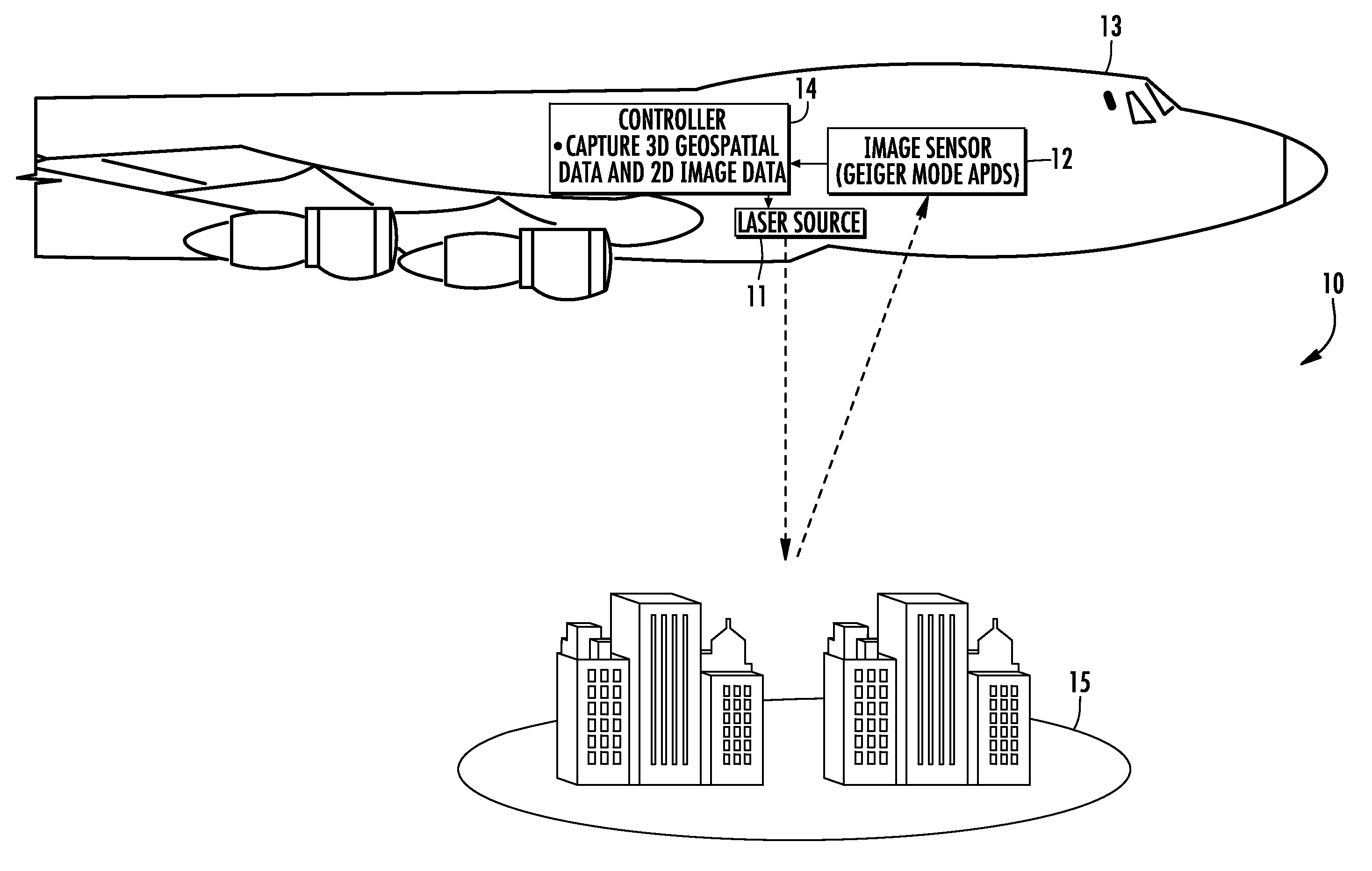
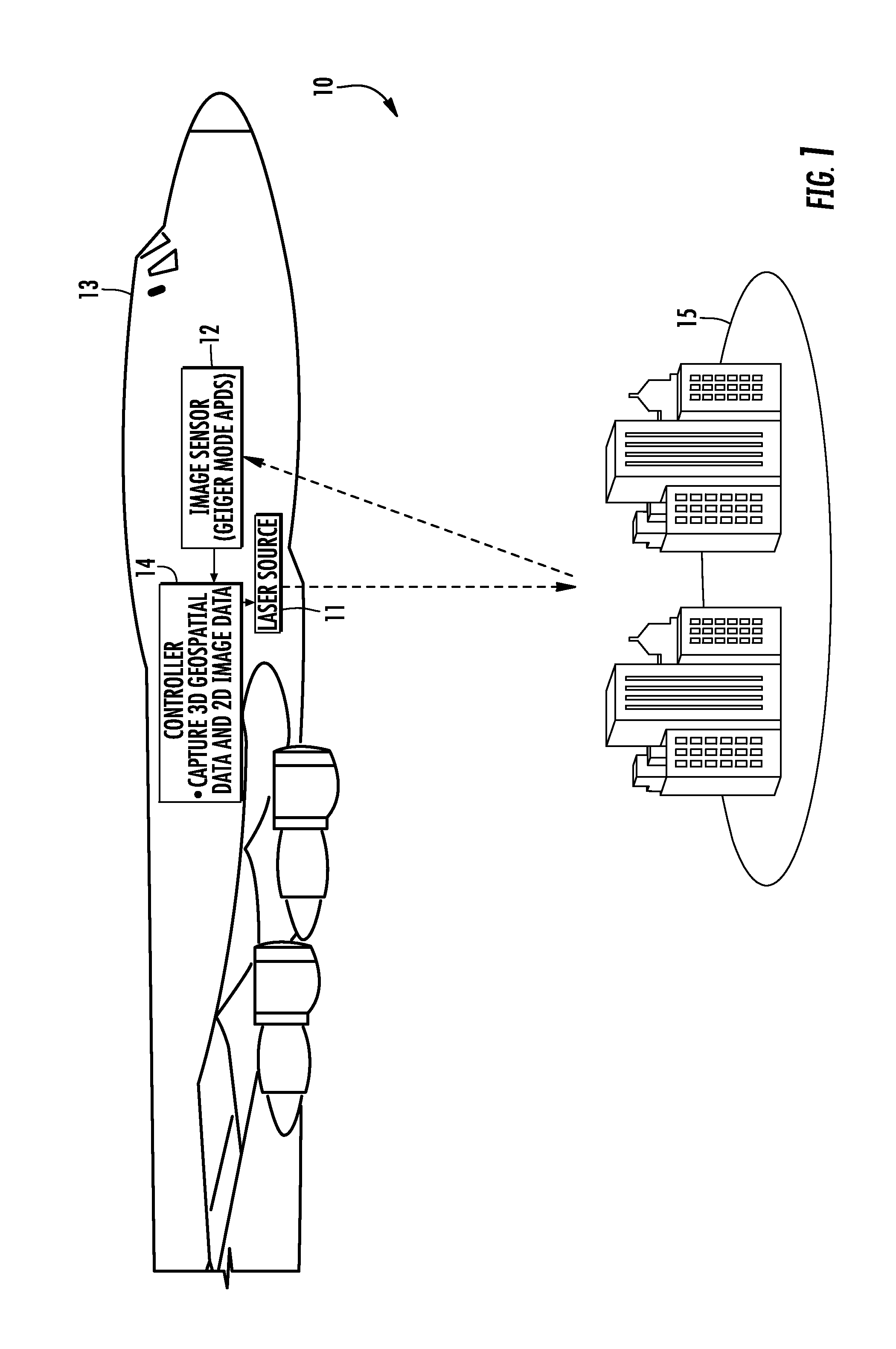
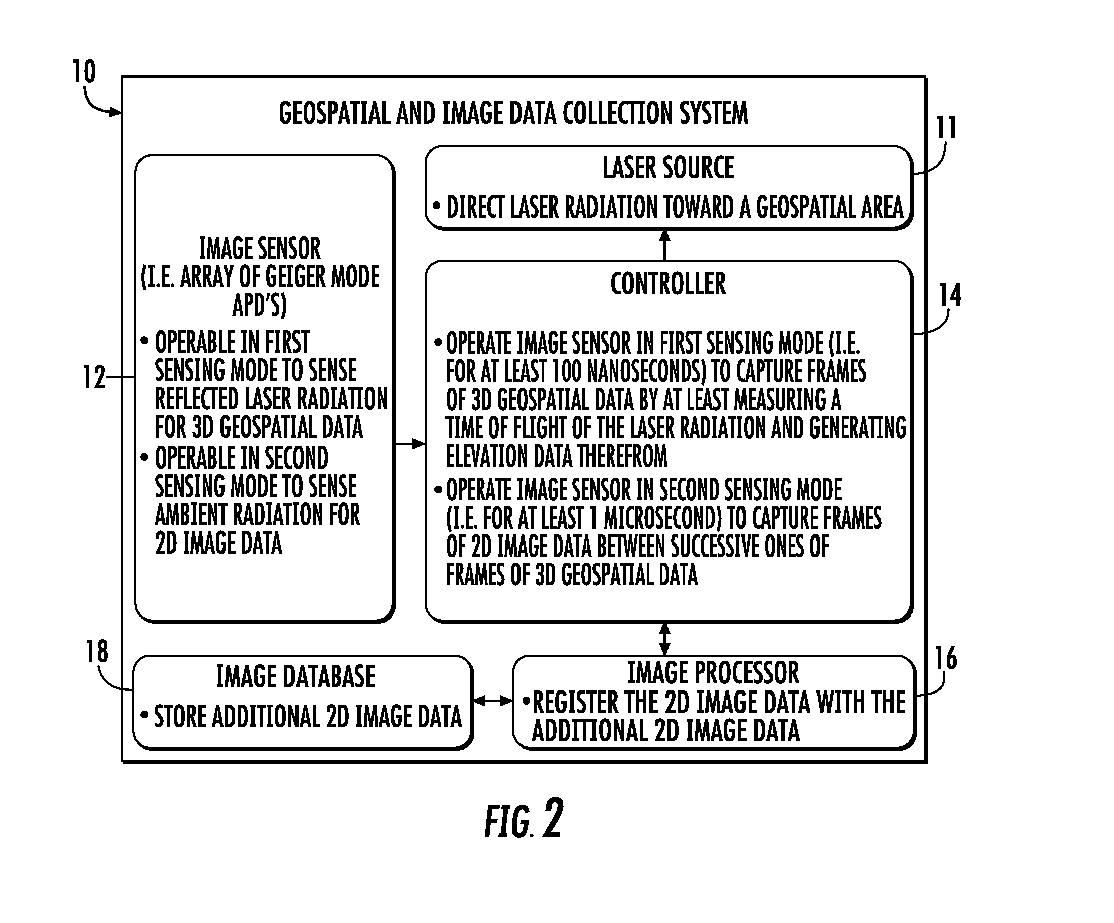
[0019]Referring initially to FIGS. 1-2, a geospatial and image data collection system 10 is now described. The system 10 may be carried by an aircraft 13, as shown in FIG. 1, and includes a laser source 11 for directing laser radiation toward a geospatial area 15. An image sensor 12 is operable in a first sensing mode to sense reflected laser radiation from the geospatial area representative of 3D geospatial data. Since, in this first sensing mode, the image sensor 12 is sensing reflections from radiati...


PUM


Abstract

A geospatial and image data collection system includes a laser source configured to direct laser radiation toward a geospatial area, and an image sensor. The image sensor is configured to be operable in a first sensing mode to sense reflected laser radiation from the geospatial area representative of three dimensional (3D) geospatial data, and a second sensing mode to sense ambient radiation from the geospatial area representative of two dimensional (2D) image data. In addition, a controller is configured to operate the image sensor in the first and second sensing modes to generate the 3D geospatial data and 2D image data registered therewith.

Description

FIELD OF THE INVENTION[0001]The present invention relates to the field of data collection, and, more particularly, to a geospatial and image data collection system and related methods.BACKGROUND OF THE INVENTION[0002]Three dimensional (3D) models of geographical areas, such as topographical maps, may be used for many applications. For example, topographical models may be used in flight simulators. Furthermore, topographical models of man-made structures (e.g., cities) may be extremely helpful in applications such as cellular antenna placement, urban planning, disaster preparedness and analysis, and mapping, for example.[0003]Various types and methods for making 3D models are presently being used. One common 3D model is the digital elevation model (DEM). A DEM is a sampled matrix representation of a geographical area which may be generated in an automated fashion by a computer. In a DEM, coordinate points are made to correspond with a height value.[0004]In order to form DEMs and othe...

Claims


Application Information

Patent Timeline
Patent Type & Authority Patents(United States)
IPC IPC(8): G01C11/02G01S17/89G01S17/02G01S17/86
CPCG01C11/02G01S17/023G01S17/89G01S17/86
Inventor CLIFTON, WILLIAM EARLE
Owner HARRIS CORP
Features
  • R&D
  • Intellectual Property
  • Life Sciences
  • Materials
  • Tech Scout
  • Unparalleled Data Quality
  • Higher Quality Content
  • 60% Fewer Hallucinations
Learn More