Method for assisting the navigation of an aircraft with correlation of dynamic information with a 4D flight trajectory

a technology of dynamic information and flight trajectory, applied in the direction of navigation instruments, instruments, static indicating devices, etc., can solve the problems of complex work, inability to allow, and difficult to manage dynamic information than static information, so as to achieve optimal readability and appreciation of the situation

Active Publication Date: 2016-12-20
THALES SA
View PDF15 Cites 7 Cited by
  • Summary
  • Abstract
  • Description
  • Claims
  • Application Information

AI Technical Summary

Benefits of technology

[0055]It allows spatio-temporal data to be determined that is coherent with the 3D trajectory displayed, by taking into account the time axis over forward time scales allowing the crew to capture on a single representation the predicted time variation of the situation, without however cluttering the displays, in order to preserve an optimum readability and appreciation of the situation.
[0057]The solution allows the time scales around the predicted trajectory to be adjusted with the aim of assisting the decision (diversion, anticipated application of procedures, etc.).

Problems solved by technology

This dynamic information is more difficult to manage than static information, since it is necessary to extrapolate and to correlate disparate pieces of information.
This work is complex because several weather charts need to be crossed, and the predicted 3D position of the aircraft mentally visualized on these charts together with the time-dependent aspect.
This method does not allow:the information relating to the flight to be assimilated at a glance, in its entirety,the variation of dynamic aeronautical information to be captured at a given moment; if this information changes and has an impact on the progress of the flight, the crew has to estimate at what time that will take place, and manually moves the aircraft icon in order to try and “find” the moment in time in question.
This method does not allow a developing situation around the 4D trajectory to be presented in an effective manner since it does not display anything; indeed, the display on the current screens in 2D of a weather “volume” is not possible.
This does not allows the changes in dynamic aeronautical information with time to be seen at a given time; if this information changes and impacts the progress of the flight, the crew have to estimate at what time this will occur, to manually input the time in question in order to see both the predicted aircraft icon and the weather around this aircraft icon.
However, this does not solve the problem consisting in displaying in an effective manner a developing situation around the 4D trajectory, since it calculates the wind at a given point of the trajectory and does not display it elsewhere.
However, as before, this does not solve the problem consisting in displaying in an effective manner a developing situation around the 4D trajectory since it predicts the wind at a given 3D point of the trajectory and does not display it elsewhere.
However, this does not give an overall view of the trajectory, and makes the crew perform trial and error operations in order to estimate if a potential problem could exist at a given point.

Method used


Image

  • Method for assisting the navigation of an aircraft with correlation of dynamic information with a 4D flight trajectory
  • Method for assisting the navigation of an aircraft with correlation of dynamic information with a 4D flight trajectory
  • Method for assisting the navigation of an aircraft with correlation of dynamic information with a 4D flight trajectory

Examples


first embodiment

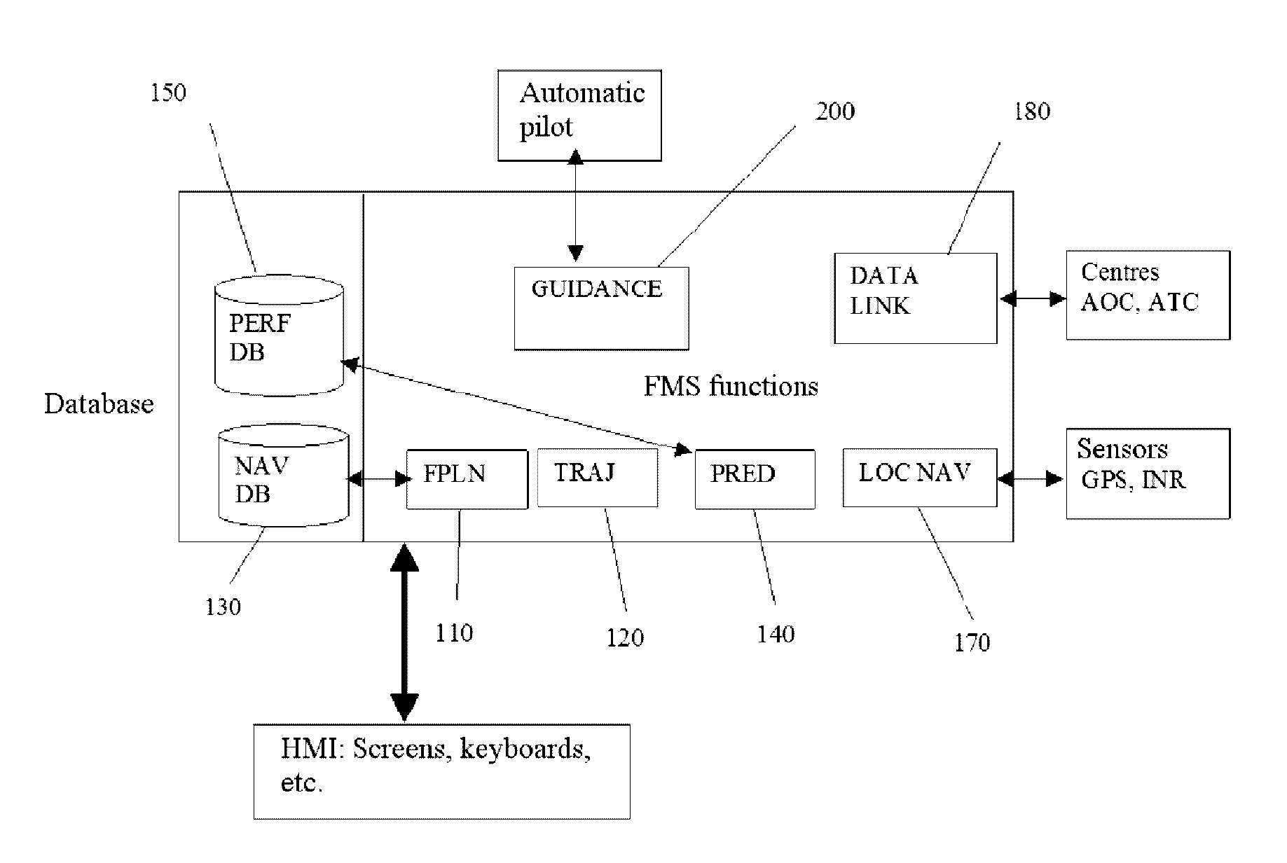
[0256] described with reference to FIG. 8b, the BDD1 is hosted in the FMS as a new database in which the data from the equipment (sensors, etc.) other than the FMS are stored.

[0257]The potential discretization of the trajectory is carried out by the module TRAJ.

[0258]The selection of the data is carried out by the selection HMI.

[0259]Based on the selections carried out by the pilot, the correlation of the time data is carried out by the module PRED, together with the conditioning and the transmission of the data to the display screens, the trajectory and the data being transmitted to the display screens in the cockpit (Navigation Display and / or Vertical Display).

[0260]Certain functions may be provided by modules integrated into an EFB (Electronic Flight Bag), an ANS (Airport Navigation System, i.e. ground taxiing system) or a portable PC or tablet, or lastly onto screens of ground tools, with for example a dedicated correlation system.

second embodiment

[0261] described with reference to FIG. 8c, the FMS (or EFB or ANS) supplies the trajectory to the BDD1. The other equipment (ground or on-board) sends the data to be displayed in the BDD1. A correlator is responsible for the exploitation of the data from the various pieces of equipment, on the basis of pilot selections via the selection HMI. The correlator formats the trajectory and the data and sends them to the CDS for displaying.

third embodiment

[0262] described with reference to FIG. 8d, the correlation of the data with the trajectory is carried out by the CDS, on the basis of pilot selections made via the selection HMI. According to this embodiment, the FMS (or EFB or ANS) supplies the trajectory in the BDD1. The other equipment (ground or on-board) sends the data to be displayed in the BDD1.

[0263]Other embodiments are possible in which the BDD1 is no longer a centralized database, but each piece of equipment stores its data and, during the correlation step, the data from each piece of equipment is read.


PUM


Abstract

A method for assisting the navigation of an aircraft comprises: assembly by families of data by a processing unit of predetermined data and acquired data, including meteorological data, the families being predefined, each data value being associated with a time window of validity; formatting the data of the families to associate with each data value a type of graphical representation as text or a scalar, vector, surface, or volume; selection of families of data to be displayed; choice of a display time window for each family of data to be displayed; spatio-temporal discretization of the trajectory; spatio-temporal correlation of the discretized trajectory with each family of data as a function of the time windows of validity, in the display time windows of the family, to extract a sub-assembly from each family of data, by the processing unit; display of the sub-assemblies in a single representation on the same display screen.

Description

CROSS-REFERENCE TO RELATED APPLICATION[0001]This application claims priority to foreign French patent application No. FR 1401105, filed on May 16, 2014, the disclosure of which is incorporated by reference in its entirety.FIELD OF THE INVENTION[0002]The field of the invention is that of navigation aids for aircraft and, more precisely, of a dynamic information correlation aid with a 4D flight trajectory.BACKGROUND[0003]Aeronautical information is commonly supplied to the crew. This of course relates to weather information, but also to the other dynamic information likely to be encountered during the flight:[0004]state of the air spaces traversed (opening or closing times),[0005]MTO acronym for the expression Meteo: time projection of the minimum heights and distances with regard to the visibility in the approach phase (such as for example the back-up airports which must be adapted to the ETOPS criteria (Extended range Twin engine Operation Performance Standards, procedure allowing n...

Claims


Application Information

Patent Timeline
Patent Type & Authority Patents(United States)
IPC IPC(8): G01C21/00G01C23/00G06T11/20B64D43/00G09G5/36
CPCG06T11/206B64D43/00G01C21/00G01C23/005G09G5/36G06T2210/32G06T2210/61G09G2380/12G08G5/0091G08G5/0021G08G5/0034
Inventor COULMEAU, FRANCOISVAUTIER, SONIABONAMY, FREDERIC
Owner THALES SA
Why Eureka
Try Eureka