Electronic map having road side panoramic image tape, manufacturing thereof and interest point annotation method

A technology for electronic maps and panoramic images, which is applied in the directions of maps/plans/charts, educational appliances, electrical digital data processing, etc. location-accurate effect

Inactive Publication Date: 2009-08-12
祁刃升
View PDF3 Cites 39 Cited by
  • Summary
  • Abstract
  • Description
  • Claims
  • Application Information

AI Technical Summary

Problems solved by technology

This method adopts the same principle as the Chinese invention patent CN1845094A, that is, to collect continuous image sequences and establish position associations, so the problems faced are the same, that is, the storage space occupied by the picture set is large and there is a certain complexity in establishing position associations

Method used


Image

  • Electronic map having road side panoramic image tape, manufacturing thereof and interest point annotation method
  • Electronic map having road side panoramic image tape, manufacturing thereof and interest point annotation method
  • Electronic map having road side panoramic image tape, manufacturing thereof and interest point annotation method

Examples


Embodiment Construction

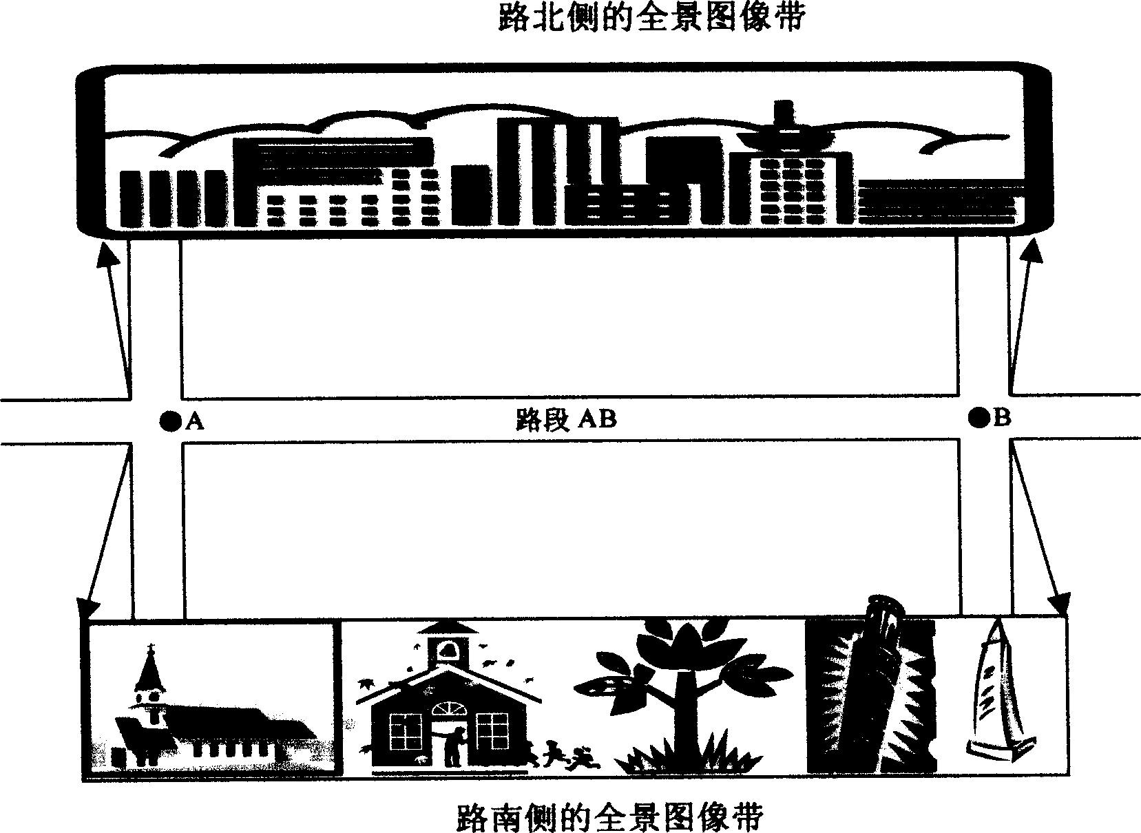
[0035] An electronic map with a roadside panoramic image belt provided by the present invention, wherein the entire panoramic image belt of real street scenes on both sides of the road is stored in the database file of the electronic map, and the user interface of the electronic map is provided with Display the control of the panoramic image belt, specify the road section through the human-computer interaction device, the service program responds to this request, and display the panoramic image belt associated with it on both sides of the selected road section (such as figure 1 shown).

[0036] The controls include at least function buttons and / or menus; the human-computer interaction device includes a mouse and / or a keyboard.

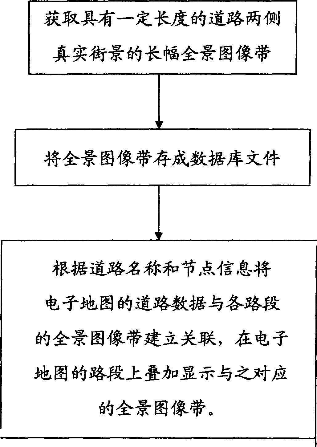
[0037] The present invention also provides a method for making the above-mentioned electronic map with roadside panoramic image strips.

[0038] figure 2 It is the method for making the above-mentioned electronic map with roadside panoramic image ba...


PUM


Abstract

The invention relates to an electronic map, in particular to an electronic map provided with roadside panoramic view picture strips, a method for manufacturing the same, and a method for marking interested places. The invention is dependent on road information of the prior electronic map and the correlation between the road information and the panoramic view picture strips for the overlay of the panoramic view picture strips showing both roadsides on roads displayed on the electronic map. Each panoramic view picture strip is a narrow picture which records all the scenes on a section of road, and users can comprehensively, continuously and intuitively know the conditions on both sides of a street through the panoramic view picture strip and determine the actual position of a place in the panoramic view picture strip on the electronic map.

Description

technical field [0001] The invention relates to an electronic map, in particular to an electronic map with a roadside panorama image band, and methods for making and marking interest points. Background technique [0002] Existing electronic maps mainly display basic road information, plus a limited number of points of interest. The location information of POIs is obtained in two ways. The first is that professional institutions with surveying and mapping qualifications use professional equipment to collect on-the-spot and measure the precise coordinates of points of interest. The information obtained in this way is accurate, but the disadvantage is that it has high requirements for collectors and collection equipment, and the operation process is cumbersome and costly. Therefore, this method is generally applicable to the collection of some important points of interest, and cannot take into account the large number of points of interest in catering, entertainment, and othe...

Claims


Application Information

Patent Timeline
Patent Type & Authority Applications(China)
IPC IPC(8): G09B29/00G09B29/10G06F17/30
Inventor 祁刃升
Owner 祁刃升
Why Eureka
Try Eureka