Navigation device and method thereof

A navigation device and position point technology, applied in the field of navigation, can solve the problems of inconvenience for drivers, more time for drivers to arrive, and difficulty in time.

Active Publication Date: 2010-07-28
NEUSOFT CORP
View PDF0 Cites 19 Cited by
  • Summary
  • Abstract
  • Description
  • Claims
  • Application Information

AI Technical Summary

Problems solved by technology

[0005] However, when the driver wants to drive to pick up the pedestrians who do not drive and go to the destination together, if the pedestrians are fixed, the position of the pedestrians may be relatively remote, such as in an alley or alley, so the driver It takes more time or is extremely difficult for the driver to reach the location, which brings a lot of inconvenience to the driver

Method used


Image

  • Navigation device and method thereof
  • Navigation device and method thereof
  • Navigation device and method thereof

Examples


Embodiment Construction

[0028] Specific embodiments of the present invention will be described in detail below in conjunction with the accompanying drawings.

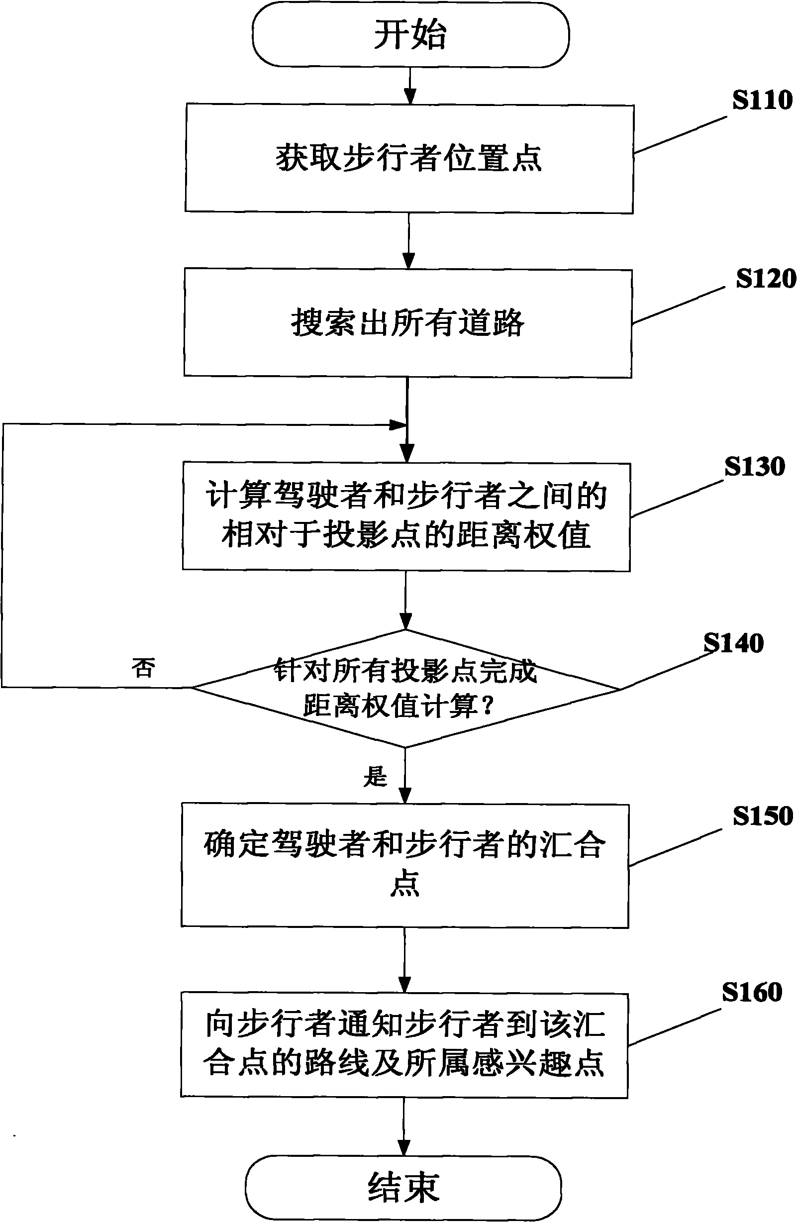
[0029] figure 1 A flow chart of a method according to the invention for navigating when a driver picks up a pedestrian is shown.

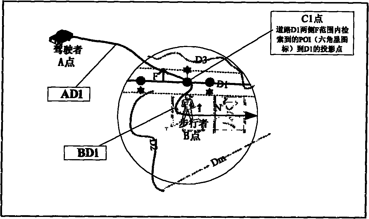
[0030] Such as figure 1 As shown, when the driver wants to drive to pick up a pedestrian at a certain location, first, in step S110, the driver obtains the location information of the pedestrian, for example, through a wireless communication device, and sets the location information in the vehicle. on your navigation device as a pedestrian location point.

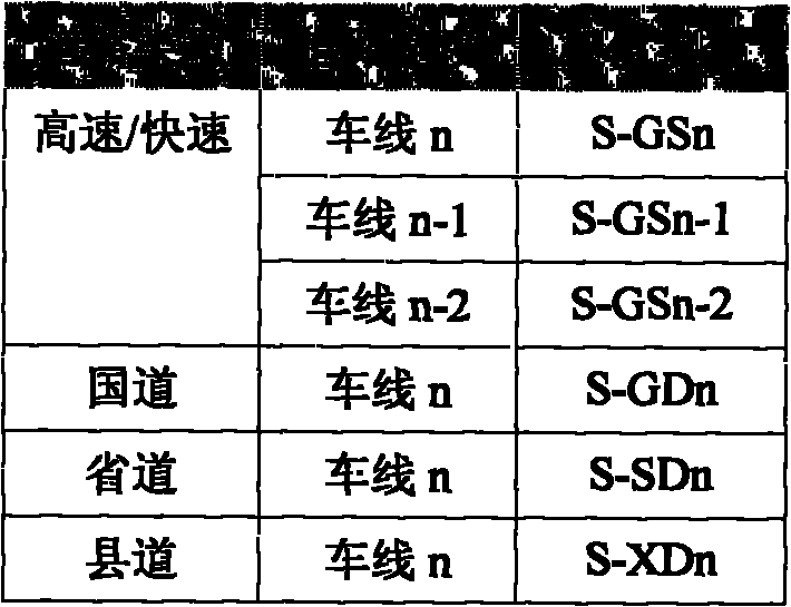
[0031] After obtaining the pedestrian's position point, the flow proceeds to step S120. In step S120, the driver uses the navigation device equipped on the vehicle to search for the preset distance range within the preset distance range (hereinafter, the preset distance is assumed to be N) centered on the pedestrian position point. All the roads in which the...


PUM


Abstract

The invention discloses a method for navigating a driver to pick up a pedestrian, comprising the following steps of: acquiring position information of the pedestrian and setting the position information into a position of the pedestrian by the driver; searching all roads on which bicycles can run in the preset distance range taking the position of the pedestrian as a center; acquiring each interested point at two sides of all the roads on which the bicycles can run in the preset distance range, calculating a projective point from the interested point to the road to which the interested point belongs, calculating the summation of the weighting running distance from the driver to the projective point and the walking distance from the pedestrian to the projective point by a navigation device, wherein the summation is used as a distance weight value between the driver and the pedestrian relative to the projective point; comparing the distance weighting value of each projective point and determining a projective point with the minimum distance weighting value as a junction point of the driver and the pedestrian; using a path from the bicycle to the junction point as a guide path for the driver and informing the pedestrian of the path information from the pedestrian to the junction point and the interested point to which the junction point belongs.

Description

technical field [0001] The present invention relates to the technical field of navigation, and more specifically, to a navigation device and method for navigating when a driver picks up a pedestrian. Background technique [0002] With the continuous development of public transportation facilities, drivers increasingly need navigation equipment to provide information assistance, for example, to provide drivers with road traffic conditions, driving routes to destinations or points of interest (POI, point of interest), etc. . The POI refers to content such as facilities marked in a navigation map, such as restaurants, hotels, hospitals, tourist attractions, and the like. [0003] In the existing navigation devices, there is usually a route guidance function for allowing the user to easily drive to a desired destination without getting the wrong way. According to this route guidance function, in consideration of factors such as distance, time, cost, etc., using the map informa...

Claims


Application Information

Patent Timeline
Patent Type & Authority Applications(China)
IPC IPC(8): G01C21/34
Inventor 夏楠
Owner NEUSOFT CORP
Why Eureka
Try Eureka