Ground sedimentation monitoring system
A monitoring system and land subsidence technology, which is applied in the direction of measuring devices, measuring instruments, surveying and navigation, etc., can solve problems such as data processing, analysis support, connection errors, and network node expansion, etc., to make up for the long period of manual monitoring Effect
- Summary
- Abstract
- Description
- Claims
- Application Information
AI Technical Summary
Problems solved by technology
Method used
Image
Examples
Embodiment Construction
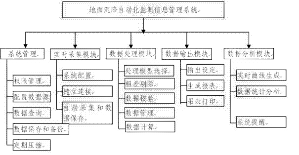
[0029] The features of the present invention and other related features will be further described in detail below in conjunction with the accompanying drawings through embodiments, so as to facilitate the understanding of those skilled in the art:
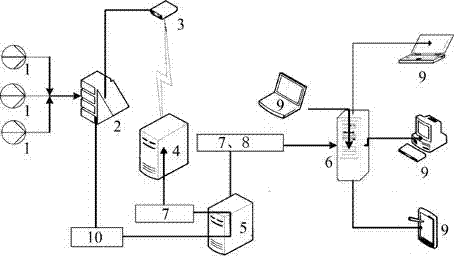
[0030] Such as Figure 1-7 As shown, the labels respectively represent: sensor 1, data acquisition unit 2, CDMA module 3, fixed IP server 4, data acquisition and processing server 5, database server 6, local area network 7, Internet 8, user 9, satellite transmission system 10.
[0031] 1. Brief description of system principle and operation mode
[0032] System network operating environment see figure 1 shown. It can be seen from the figure that the whole system is mainly composed of three parts: the control system of the land subsidence monitoring center, which is the data acquisition and processing server, the transmission system and the on-site automatic measurement system. Among them, the central control system includes a dat...
PUM
 Abstract
Description
Claims
Application Information
 - R&D
- Intellectual Property
- Life Sciences
- Materials
- Tech Scout
- Unparalleled Data Quality
- Higher Quality Content
- 60% Fewer Hallucinations
Browse by: Latest US Patents, China's latest patents, Technical Efficacy Thesaurus, Application Domain, Technology Topic, Popular Technical Reports.
© 2025 PatSnap. All rights reserved.Legal|Privacy policy|Modern Slavery Act Transparency Statement|Sitemap|About US| Contact US: help@patsnap.com


