Ground sedimentation monitoring system

A monitoring system and land subsidence technology, applied in the directions of measuring devices, measuring instruments, surveying and mapping, and navigation, etc., can solve the problems of poor data processing and analysis support, difficult connection, and no support for network node expansion, etc., to make up for the long period of manual monitoring. Effect

Active Publication Date: 2010-08-25
上海市地质调查研究院 +1
View PDF5 Cites 25 Cited by
  • Summary
  • Abstract
  • Description
  • Claims
  • Application Information

AI Technical Summary

Problems solved by technology

[0004] This kind of data transmission mode is not safe, and problems such as connection difficulties and connection errors often occur, and real-time automatic data transmission cannot be realized
Moreover, the above-mentioned monitoring system does not support the expansion of network nodes and the adoption of new equipment; it also does not support the processing and analysis of subsequent data.

Method used


Image

  • Ground sedimentation monitoring system
  • Ground sedimentation monitoring system
  • Ground sedimentation monitoring system

Examples


Embodiment Construction

[0029] The features of the present invention and other related features will be further described in detail below in conjunction with the accompanying drawings through embodiments, so as to facilitate the understanding of those skilled in the art:

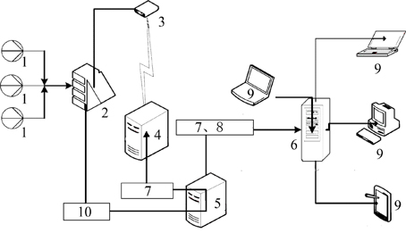
[0030] As shown in Figure 1-7, the labels respectively represent: sensor 1, data acquisition unit 2, CDMA module 3, fixed IP server 4, data acquisition and processing server 5, database server 6, local area network 7, Internet 8, user 9, satellite transmission System 10.

[0031] 1. Brief description of system principle and operation mode

[0032] The operating environment of the system network is shown in Figure 1. It can be seen from the figure that the whole system is mainly composed of three parts: the control system of the land subsidence monitoring center, which is the data acquisition and processing server, the transmission system and the on-site automatic measurement system. Among them, the central control system includes...


PUM


Abstract

The invention relates to the technical field of geological condition monitoring, in particular to a ground sedimentation monitoring system which comprises a plurality of sensors, a programmed data acquisition unit and a data acquisition processing server. The sensors are arranged in a borehole extensometer and a water level well. A star topology structure consists of the sensors and the data acquisition unit, and the data acquisition processing server establishes connection with the data acquisition unit. The ground sedimentation monitoring system is characterized in that the data acquisition unit is connected with a CDMA (Code Division Multiple Access)module which is connected with a fixed IP server by a CDMA network, the fixed IP server is connected with a communication port of the data acquisition processing server by an LAN (Local Area Network), unique code corresponding to a placing area is stored in each sensor, and the data acquisition processing server is internally provided with an item table for recording and setting the code information corresponding to sensor codes. The invention has the advantages of acquiring ground sedimentation monitoring data in real time with high efficiency and overcoming the defects of long period and less data of manual monitoring.

Description

technical field [0001] The invention relates to the technical field of geological condition monitoring, in particular to a ground subsidence monitoring system. Background technique [0002] Land subsidence includes natural land subsidence and man-made land subsidence. One of the natural land subsidence is the diagenetic process of the loose or semi-loose sedimentary layer on the surface under the action of gravity, from loose to fine; the other is the land subsidence caused by geological tectonic movement, earthquake, etc. The hazards of land subsidence mainly include: (1) destroying buildings and production facilities; (2) not conducive to construction and resource development. Areas where land subsidence occurs are areas with unstable strata, requiring more investment in construction and resource development during urban construction and resource development, and production capacity is also limited; (3) causing seawater intrusion. Land subsidence areas mostly appear in c...

Claims


Application Information

Patent Timeline
Patent Type & Authority Applications(China)
IPC IPC(8): G01C15/00H04W84/18
Inventor 许准唐继民郭陈
Owner 上海市地质调查研究院
Why Eureka
Try Eureka