Remote sensing image retrieval method based on feature selection and semi-supervised learning

A semi-supervised learning, remote sensing image technology, applied in the field of remote sensing image retrieval, can solve problems such as increasing user burden

Inactive Publication Date: 2010-10-06
HOHAI UNIV
View PDF1 Cites 39 Cited by
  • Summary
  • Abstract
  • Description
  • Claims
  • Application Information

AI Technical Summary

Problems solved by technology

[0004] Relevance feedback is the most commonly used learning strategy in CBIR. It relies on the human-computer interaction process, and the user continuously

Method used


Image

  • Remote sensing image retrieval method based on feature selection and semi-supervised learning
  • Remote sensing image retrieval method based on feature selection and semi-supervised learning
  • Remote sensing image retrieval method based on feature selection and semi-supervised learning

Examples


Embodiment Construction

[0045] The technical scheme of the present invention is described in detail below in conjunction with accompanying drawing:

[0046] Use method of the present invention to carry out retrieval experiment to different land cover (land cover), wherein the retrieval of existing soil erosion area also has settlement, woodland, the retrieval of general targets such as lake enclosure; Concrete retrieval is according to the following steps:

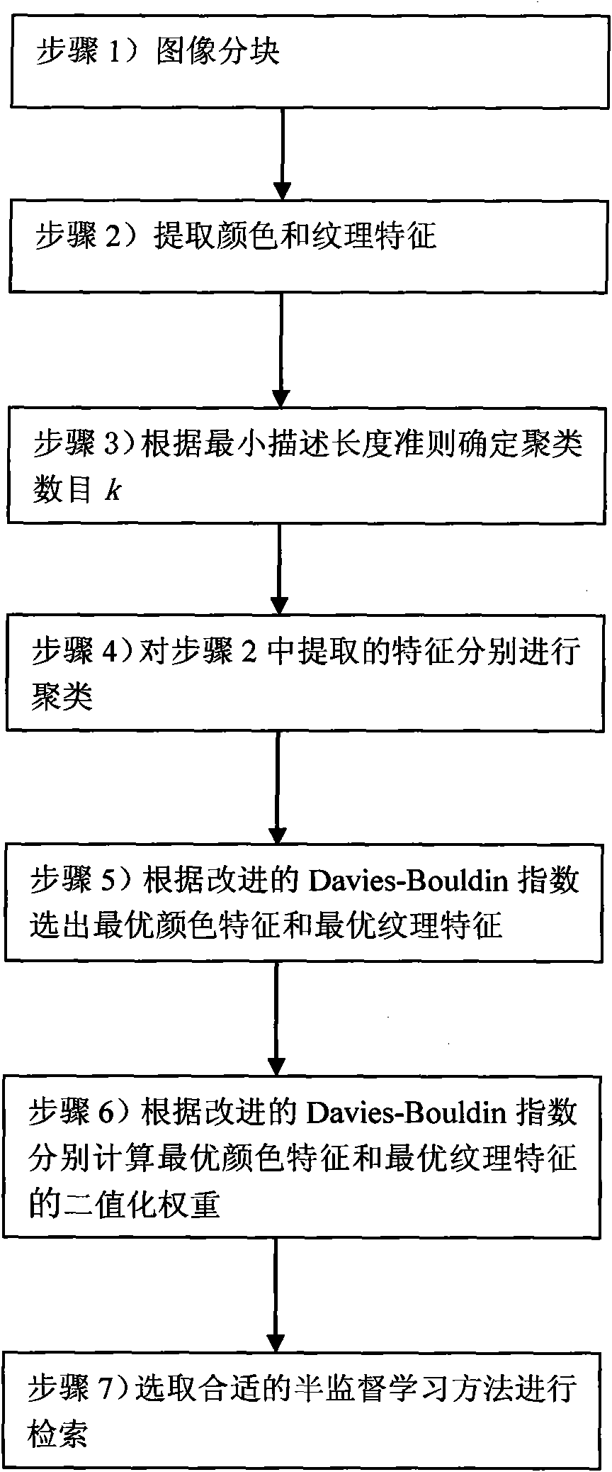
[0047] Step 1) dividing the image to be retrieved into blocks;

[0048] In this specific embodiment, in order to avoid dividing the same target into different small blocks, an overlapping block strategy is adopted, and the size of each block is, length=min(128, sample image length), width=min(128, sample image width), blocks overlap by 1 / 2 length by 1 / 2 width pixels;

[0049] Step 2) extracting each color feature and texture feature of the image to be retrieved respectively;

[0050] In this specific embodiment, HSI color feature, Lab color fea...


PUM


Abstract

The invention discloses a remote sensing image retrieval method based on feature selection and semi-supervised learning. In the method, an optimal color feature and an optimal textural feature are selected respectively by utilizing a clustering method according to a minimum description length criterion and an improved Davies-Bouldin index; and then an appropriate semi-supervised learning method is selected according to the binarization weight of the optimal color feature and the optimal textural feature for carrying out remote sensing image retrieval. Compared with the traditional remote sensing image retrieval method, the invention not only can greatly improve the retrieval quality, but also can reduce the calculate quantity in the retrieval process and improve the retrieval speed.

Description

technical field [0001] The invention relates to an image retrieval method, in particular to a remote sensing image retrieval method. Background technique [0002] With the continuous development of remote sensing technology, the number of remote sensing images obtained every day has increased dramatically, and the research on automatic query and retrieval technology of remote sensing images has gradually become an urgent research topic. At present, scholars at home and abroad have proposed many methods for content-based remote sensing image retrieval (CBIR), such as texture features based on Gabor transform, combination of color features and texture features, fusion of texture features and spatial information, and similarity measurement of histogram features. method, and methods based on GIS spatial semantics. Zhu Bin proposed to use Gabor texture features to retrieve aerial images [Bin Zhu, Marshall R, Hsinchun C. Creating a large-scale content-based airphoto image digital...

Claims


Application Information

Patent Timeline
IPC IPC(8): G06F17/30G06K9/46G06K9/62
Inventor 李士进朱佳丽朱跃龙万定生冯钧余宇峰
Owner HOHAI UNIV
Why Eureka
Try Eureka