Vehicle navigation device

A vehicle navigation and vehicle technology, which is applied in the direction of measuring devices, surveying and navigation, road network navigators, etc., can solve the problems of inability to receive GPS satellite signals, inability to locate correctly, etc., and achieve the effect of accurate navigation services

Inactive Publication Date: 2011-04-13
陈宗炜
View PDF0 Cites 49 Cited by
  • Summary
  • Abstract
  • Description
  • Claims
  • Application Information

AI Technical Summary

Problems solved by technology

[0017] When the GPS satellite signal is blocked, the GPS navigator may not be able to locate correctly, such as under an elevated road or in a tunnel. Now there are some patents that have solved the auxiliary navigation when the GPS satellite signal is blocked. Therefore, the present invention When discussing the positioning of GPS navigators, it is believed that GPS navigators can be positioned under elevated roads and in tunnels, even if they cannot receive GPS satellite signals temporarily

Method used


Image

  • Vehicle navigation device
  • Vehicle navigation device
  • Vehicle navigation device

Examples


Embodiment Construction

[0055] Embodiments of the present invention will be described in detail below in conjunction with the accompanying drawings.

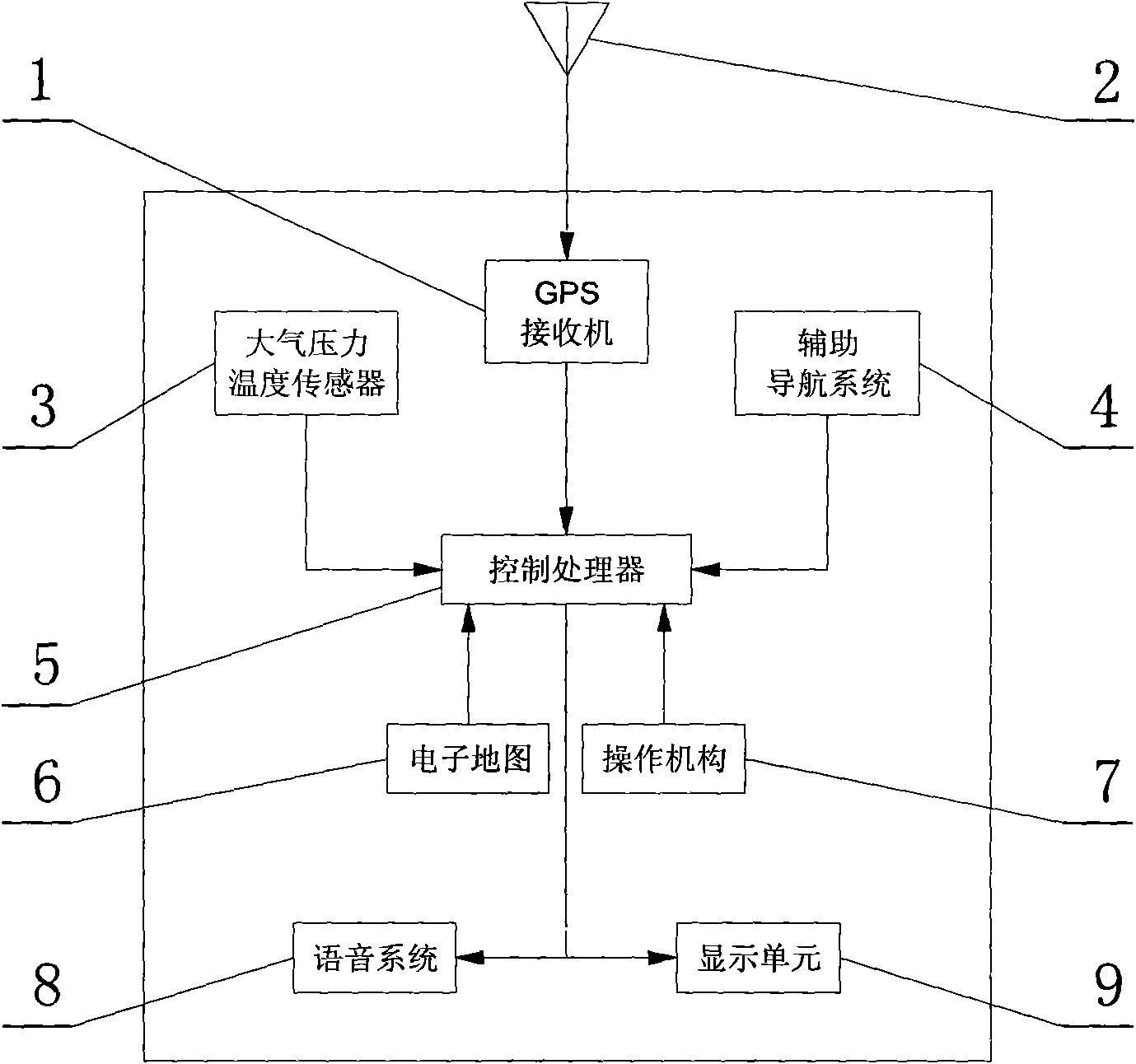
[0056] exist figure 1 middle

[0057] GPS receiver 1, receiving positioning signals from GPS navigation satellites

[0058] GPS Antenna 2, the antenna for the GPS receiver

[0059] Atmospheric pressure and temperature sensor 3, judge whether vehicle rises (or descend) certain relative height according to atmospheric pressure and temperature, judge whether vehicle goes up and down ramp, is an important part of the present invention;

[0060] Auxiliary navigation system 4, because the present invention also needs more accurate vehicle positioning in the areas with poor GPS navigation signals such as under elevated roads or in underground passages (tunnels), it is necessary to still be able to locate the vehicle when the GPS satellite navigation signal is blocked. Auxiliary system for navigation, this auxiliary navigation system includes but not limit...


PUM


Abstract

With the development of urban traffic, lots of urban road traffic is stereoscopic, and lots of elevated highways, underpasses and tunnels are built, and the stereoscopic traffic facilitates the fast traffic of urban vehicles. A common GPS (Global Position System) vehicle navigator cannot accurately determine whether a vehicle runs on the surface road or the elevated highway or the underpass on the stereoscopic traffic roads and cannot provide accurate navigation service. A GPS vehicle navigator provided by the invention works out the relative height difference before and after the vehicle passes through a ring road through measuring the atmospheric pressure and the temperature before and after the vehicle passes through the ring road, thereby being capable of judging whether the vehicle runs on the surface road or the elevated highway or the underpass and providing the navigation service for a driver.

Description

technical field [0001] The invention relates to a vehicle navigation device, which is characterized in that it can determine the specific position of the vehicle when driving on a three-dimensional traffic road (ground road, elevated road, underground road), especially can determine whether the vehicle is on the ground road or the elevated road or whether it is on the ground road or the elevated road. Driving on underground roads. Background technique [0002] At present, the use of the Global Positioning System (GPS) has been very popular. The GPS can provide positioning and navigation information such as longitude, latitude, altitude, speed, heading, and time around the world. At present, GPS navigators are more and more applied to ground vehicles such as automobiles, and GPS navigators and navigation map software guide drivers to reach their destinations. [0003] With the development of urban traffic, many urban road traffic has been three-dimensional, and many elevated...

Claims


Application Information

Patent Timeline
Patent Type & Authority Applications(China)
IPC IPC(8): G01C21/34G01C5/06G01S5/02
Inventor 陈宗炜
Owner 陈宗炜
Why Eureka
Try Eureka