Interval coding-based geography markup language (GML) document index method

A technology of interval coding and documentation, used in special data processing applications, instruments, electrical digital data processing, etc.

Inactive Publication Date: 2011-05-25
FUDAN UNIV +1
View PDF2 Cites 7 Cited by
  • Summary
  • Abstract
  • Description
  • Claims
  • Application Information

AI Technical Summary

Problems solved by technology

[0006] The above methods mainly encode XML documents, without considering the large amount of spatial data in GML documents

Method used


Image

  • Interval coding-based geography markup language (GML) document index method
  • Interval coding-based geography markup language (GML) document index method
  • Interval coding-based geography markup language (GML) document index method

Examples


Embodiment Construction

[0043] 1. encoding scheme

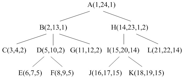
[0044] Dietz encoding needs to scan the document twice to encode each node, and Li encoding is not easy to determine the sibling relationship and predecessor-successor relationship between nodes. Considering that GML documents are often very large, the time spent on encoding should be reduced as much as possible, and each node should be encoded in the least number of scan passes. To this end, the Zhang code is extended to increase the sequence number and node category of the parent node of the node, and only one scan is required to represent each node in the GML document tree as a five-tuple:

[0045] ( docID , firstOrder , lastOrder , parentOrder , kind )

[0046] in, docID is the document number, firstOrder is the sequence number when it is first accessed during the preorder traversal of the document tree, lastOrder is the serial number when it was last accessed. parentOrder is the parent node of the node firstOrder , kind ...


PUM


Abstract

The invention discloses an interval coding-based geography markup language (GML) document index method, which belongs to the technical field of storage and query of spatial information in information technology. In the method, nodes in a GML document tree are coded in turn from a first accessed node to a last accessed node during preorder traversal; indexes of elements, attribute and texts are organized in a B+- tree mode, so that query speeds of value query and structure query are increased; the index of geometric nodes is organized in a R- tree mode, so that spatial query and analysis efficiency are improved; and an XQuery-based GML query language graphic query language (GQL) is taken as a query language, and three queries (non-spatial query, spatial query and hybrid query) are analyzed and compared. An experiment proves that a provided GML document coding scheme and an index mechanism are feasible, and value query and spatial analysis operation performed on a GML document can be effectively processed.

Description

[0001] technical field [0002] The invention belongs to the technical field of spatial information storage and query in information technology, and in particular relates to an indexing and query method of geographic label data (GML data). [0003] Background technique [0004] Geographic Markup Language GML is a set of XML-based geographic information coding tools developed by the Open Geographic Information System Organization OGC to solve the sharing of geographic data in different formats under the WebGIS environment. At present, GML, as an extensible and standardized geographic information encoding method, provides a common geographic object description standard for the modeling, transmission, storage and release of geographic information, thus enabling the interoperability between independently developed applications. become possible. GML has also developed from version 2.x of the original three base schemas (Base Schema) to version 3.x consisting of thirty base schem...

Claims


Application Information

Patent Timeline
Patent Type & Authority Applications(China)
IPC IPC(8): G06F17/30
Inventor 周水庚朱付保关佶红王炜立
Owner FUDAN UNIV
Why Eureka
Try Eureka