Method for regulating map scale automatically and dynamically for mobile terminal

A mobile terminal and dynamic adjustment technology, applied in location information-based services, electrical components, wireless communications, etc., can solve problems such as errors, inability to obtain user speed in real time, inability to automatically and dynamically adjust map scale in real time and effectively, and achieve avoid inconvenient effects

Inactive Publication Date: 2012-03-28
GUILIN UNIVERSITY OF TECHNOLOGY +1
View PDF3 Cites 13 Cited by
  • Summary
  • Abstract
  • Description
  • Claims
  • Application Information

AI Technical Summary

Problems solved by technology

At this stage, the existing methods cannot automatically and dynamically adjust the map scale to the size required by the user in real time and effectively, such as: the method of automatically and dynamically adjusting the map scale according to the speed, this method cannot obtain the user's speed in real time, and can only be approximated by the average speed Instantaneous speed can easily cause approximation errors; another example is the method of automatically and dynamically adjusting the map scale accord

Method used


Image

  • Method for regulating map scale automatically and dynamically for mobile terminal
  • Method for regulating map scale automatically and dynamically for mobile terminal
  • Method for regulating map scale automatically and dynamically for mobile terminal

Examples


Embodiment

[0025] The mobile terminal of the present invention is a mobile device that can normally receive GPS signals and can effectively acquire GPS coordinates. In the embodiment, the initialization display takes point (25.261182, 110.282886) as the center point of the map before zooming, and the initialization scale is Scale (1:12000). The test GPS coordinates are, P1 (25.26221, 110.278354), P2 (25.280923, 110.316379).

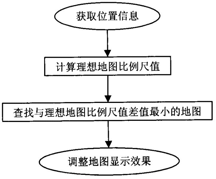
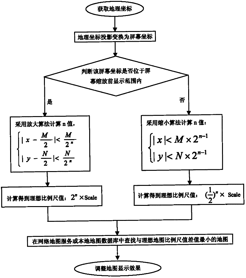
[0026] use as figure 2 The detailed flow chart of the technical solution for automatically and dynamically adjusting the map scale by the mobile terminal is shown, and the specific implementation steps of using this method are as follows:

[0027] 1. Obtain the location information of the mobile terminal:

[0028] Mobile terminal screen resolution is 320 * 480 in the present embodiment, obtains test point GPS coordinate P1, is converted into screen coordinate S1 (68,201), is used for testing automatic dynamic zoom-in map scale; Obtains test GPS coordinate point P...


PUM


Abstract

The invention discloses a method for regulating a map scale automatically and dynamically for a mobile terminal, comprising the steps of: obtaining a geographic coordinate of the located position through a GPS (Global Positioning System) in the mobile terminal in real time, and transforming the geographic coordinate into a screen coordinate through projection transformation. If the transformed screen coordinate is within a map display range before the regulation of the mobile terminal, an amplification algorithm is adopted, and whereas a reduction algorithm is adopted, thereby figuring out an ideal map scale value desired by regulation. According to the ideal map scale value, a map of which the map scale value is most approximate to the ideal map scale value is checked in a network map service or a local map database, and the map display effect is adjusted. The method provided by the invention can regulate the map scale of a mobile terminal in a movement condition automatically and dynamically according to the real time position of the mobile terminal, thereby avoiding the inconvenience that a user regulates the map scale manually.

Description

technical field [0001] The invention relates to a method for automatically and dynamically adjusting the scale of a map by a mobile terminal, and belongs to the technical field of location services. Background technique [0002] The essence of the automatic and dynamic adjustment of the map scale by the mobile terminal is that the map scale in the mobile terminal automatically adjusts the display scale of the map on its screen as the mobile terminal changes its motion state, so as to achieve the goal of providing users with geographical information that meets their needs. Automatically and dynamically adjusting the map scale is one of the important applications of location-based service technology, and it is also one of the emerging applications of navigation technology, which is widely used in mobile terminal devices such as car navigators, smart phones, and PDAs. [0003] How the mobile terminal automatically and dynamically adjusts the map scale is a very practical proble...

Claims


Application Information

Patent Timeline
IPC IPC(8): H04W4/02H04W88/02
Inventor 李景文赵卫强叶波陆军罗文彬
Owner GUILIN UNIVERSITY OF TECHNOLOGY
Why Eureka
Try Eureka