Engineering application method for network map image

A network map and application method technology, applied in special data processing applications, instruments, electrical digital data processing, etc., can solve the problems of poor real-time data, inconsistent coordinate system, monotonic data type, etc., and achieve simple and feasible data input. , The effect of efficient data acquisition and processing process

Inactive Publication Date: 2013-05-08
CHINA RAILWAY SIYUAN SURVEY & DESIGN GRP
View PDF4 Cites 7 Cited by
  • Summary
  • Abstract
  • Description
  • Claims
  • Application Information

AI Technical Summary

Problems solved by technology

[0003] The purpose of the present invention is to provide an engineering application method that can map network map images to network map images in r...

Method used


Image

  • Engineering application method for network map image
  • Engineering application method for network map image
  • Engineering application method for network map image

Examples


Embodiment Construction

[0014] The present invention will be described in further detail below in conjunction with the accompanying drawings.

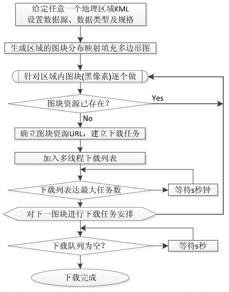
[0015] In order to adapt to flexible expression and balance network transmission load, the network electronic map service WMS network data will divide a whole plane projected world map into many small-sized tiles. For example, the size of most tiles is 256Pixel×256Pixel, such a The block division of the graph forms a basic single-layer block system, and blocks are coded according to their row and column positions. When splitting multiple graphs with different scales, a layer, row, and column stack storage organization structure of tiles is formed. In this way, when you want to access a tile, you only need to retrieve it according to its corresponding layer index and row / column index by using the Web Map Service (WMS).

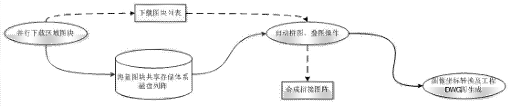
[0016] The engineering application method of the network map image provided by the present invention comprises the following steps ( figure...


PUM


Abstract

The invention relates to an engineering application method for a network map image. A data framework of the network map image is parsed by utilization of the network map service protocol, image blocks of a designated area are downloaded automatically and cocurrently from a data server to a network server, and an efficient storage, retrieval and updating mechanism is established in allusion to mass image block image data. Therefore, the automatic splicing of the image blocks and engineering drawing generation in any engineering plane coordinate are achieved. The engineering application method for the network map image has the advantages that the spatial data server is applied to the field of engineering design, and the engineering application of basic geographic data is achieved; the problem of data sources of the engineering application is solved, and an efficient and automatic data acquisition processing process is achieved; the map downloading in various scales and from various map data sources and various map types and engineering application services are provided; and a keyhole markup language (KML) area is drawn on Google Earth, and used as an area needing to be input and downloaded, and the data input is simple and feasible.

Description

technical field [0001] The invention belongs to an engineering design method, in particular to an engineering application method of a network map image that provides data support and services for engineering by using spatial data foundation and computer software technology. Background technique [0002] What is most needed in engineering (railway, highway, electric power, water supply and drainage, communication, etc.) design is base map data with rich and intuitive information, such as topographic maps. However, there is often a lack of data in this area at the initial stage of the project due to cost issues. At the same time, there are also problems such as low real-time data, inconsistent coordinate systems, monotonous data types, and unique scales. The electronic map resources (such as: Google Map, Tiantu, Bing Map, etc.) can efficiently provide engineering design with various types and timely updated electronic map resources of various scales, so that the network map im...

Claims


Application Information

Patent Timeline
IPC IPC(8): G06F17/50
Inventor 韩元利马驹邱文展王海松钟晶
Owner CHINA RAILWAY SIYUAN SURVEY & DESIGN GRP
Why Eureka
Try Eureka