Map road annotating method of navigation terminal

A technology for navigation terminals and roads, applied to maps/plans/charts, educational tools, instruments, etc., which can solve problems such as not taking into account the density distribution of road annotations in the screen, and achieve improved annotation effects, easy implementation, and simple principles Effect

Active Publication Date: 2012-04-18
SPACE STAR TECH CO LTD
View PDF5 Cites 15 Cited by
  • Summary
  • Abstract
  • Description
  • Claims
  • Application Information

AI Technical Summary

Problems solved by technology

This method is based on the principle of being able to place the location search for a road ann...

Method used


Image

  • Map road annotating method of navigation terminal
  • Map road annotating method of navigation terminal
  • Map road annotating method of navigation terminal

Examples


Embodiment Construction

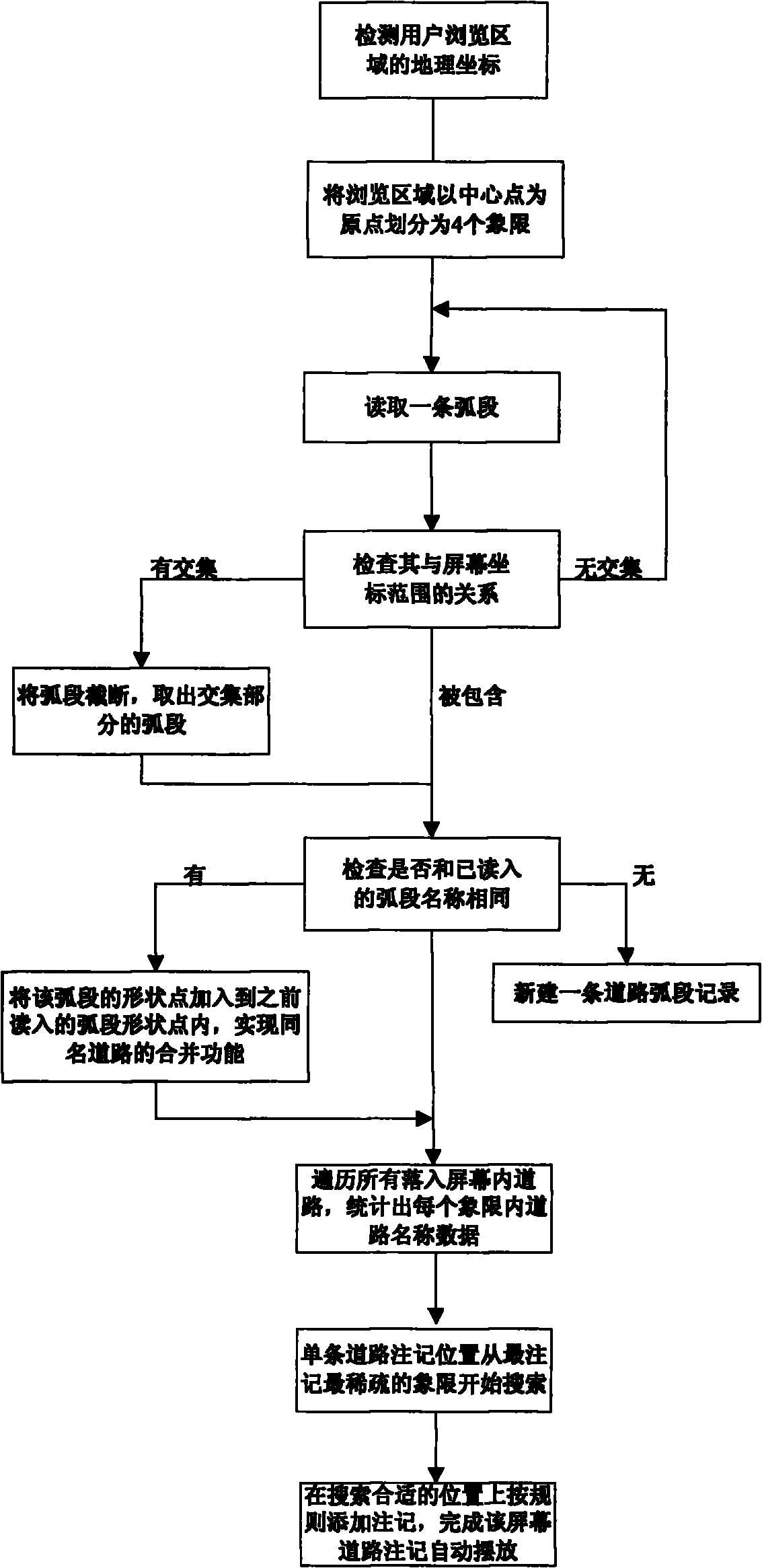
[0037] next figure 1 The flow chart shown, in combination with the above-mentioned technical solutions, further describes the present invention by means of implementation examples.

[0038] An implementation example of the present invention is to display the national road network under the scale of 1:25000 on the navigation terminal device, and take a certain display screen as an example to introduce the way of marking the road. The steps are as follows:

[0039] 1. The screen size is about 800*480 pixels, and the screen resolution is 96pixel / inch. One foot is about 0.0254 meters, and the display scale is 1:25000. According to the actual distance represented by one pixel on the screen is 6.614583333 meters, then the coordinate range that can be displayed on the screen is 5291.666667 meters*3175 meters.

[0040] 2. Under the Universal Mercator projection, if the coordinates of a new point in a certain screen are P0(X0, Y0), the geographic coordinates that can be displayed on ...


PUM


Abstract

The invention discloses a map road annotating method of a navigation terminal. The map road annotating method comprises the following steps of: displaying map data to be displayed on a screen of the navigation terminal; dividing the screen of the navigation terminal; judging and determining road information needing to be displayed; detecting the road information needing to be displayed; determining the annotation density of road names; and annotating the road names according to road grades. According to the map road annotating method, aiming at the problems of the commonly used annotating method, a grid searching method is improved by considering the density distribution of the road annotations when road annotations are displayed, thereby the optimized display effect is realized.

Description

technical field [0001] The invention relates to a method for marking roads on a map of a navigation terminal. Background technique [0002] The numbers and characters used for illustration on the map are collectively referred to as map notes. Electronic map annotations are generally divided into two categories, one is static annotations whose positions are fixed during the annotation mapping process, and the other is dynamic annotations that are marked in real time as users browse. [0003] Embedded devices have the advantages of compactness, flexibility, and good portability, but generally the display screen is relatively small, which requires navigation software to display as much map information as possible to readers on one screen. It is currently a common practice to use dynamic annotation on roads on embedded navigation terminal maps. The key to the map annotation algorithm is to calculate the position of each character, so that the annotation "does not conflict with...

Claims


Application Information

Patent Timeline
IPC IPC(8): G09B29/10
Inventor 罗军刘庆军俞能杰李亚平
Owner SPACE STAR TECH CO LTD
Why Eureka
Try Eureka