
GIS (Geographic Information System)-based emergency condition management system for tour group

A technology for emergencies and management systems, applied in the field of tourism team management systems, can solve the problems of inadequate monitoring of straggling tourists and low efficiency of rescue methods, and achieve the effect of saving labor costs and efficient processing

Active Publication Date: 2012-04-18
SUZHOU MAIPU INFORMATION TECH
View PDF5 Cites 16 Cited by
  • Summary
  • Abstract
  • Description
  • Claims
  • Application Information

AI Technical Summary

Problems solved by technology

[0004] In order to solve the problems of insufficient monitoring of laggard tourists and low efficiency of rescue methods in the existing technology for handling emergencies of tourist groups, the present invention analyzes the real-time location information of tourists on the basis of mobile terminal and geographic information system technology , design a management system that can automatically judge and deal with emergencies of tourism teams

Method used


Image

  • GIS (Geographic Information System)-based emergency condition management system for tour group
  • GIS (Geographic Information System)-based emergency condition management system for tour group
  • GIS (Geographic Information System)-based emergency condition management system for tour group

Examples


Embodiment Construction

[0045] The present invention will be described in further detail below in conjunction with the accompanying drawings and embodiments.

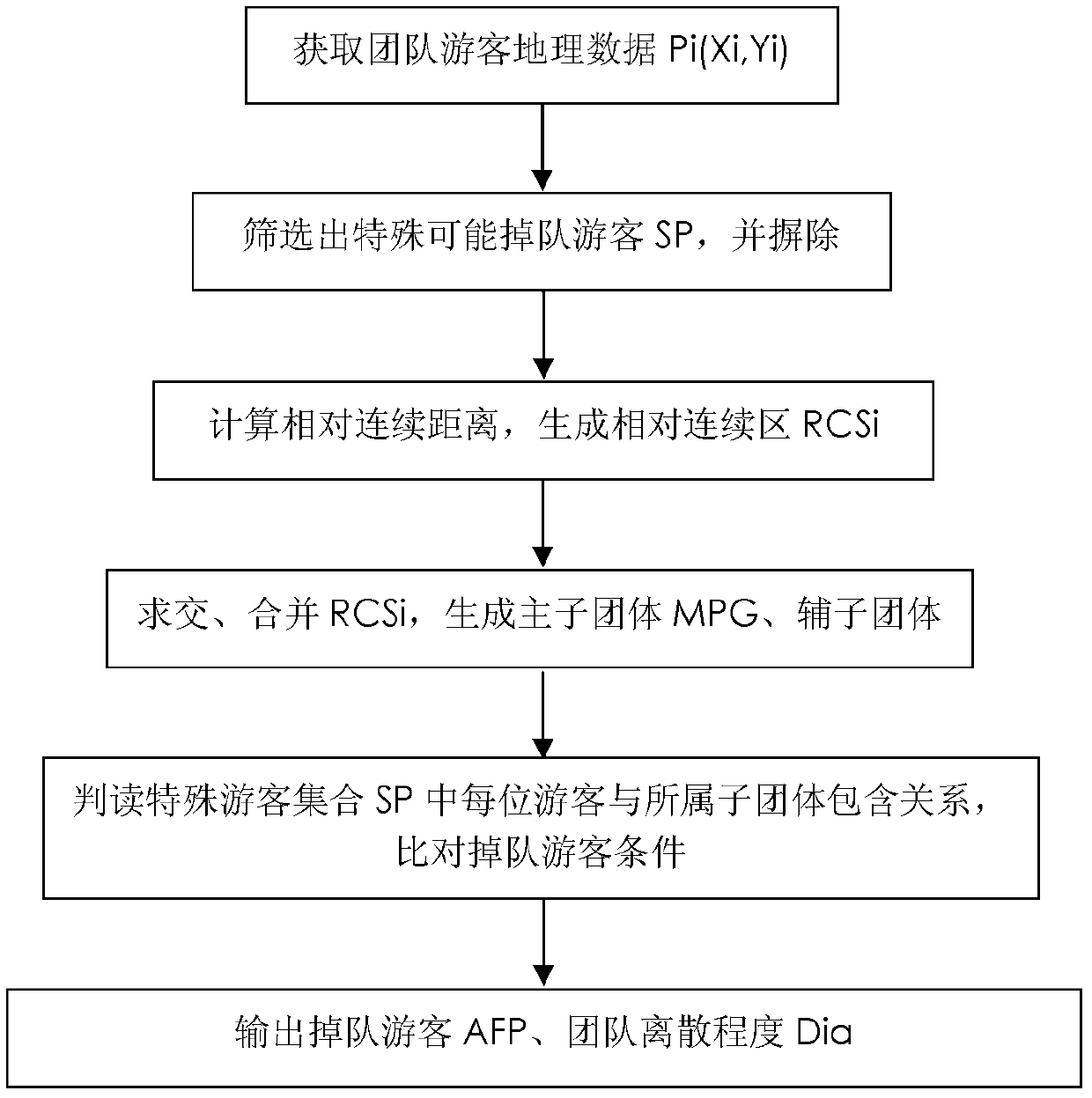
[0046] Automatically determine the components and workflow of the laggard tourists module (such as figure 2 shown):

[0047] The basic idea of ​​this module is: get the geographical coordinates Pi(Xi, Yi) of each tourist in the team, and calculate the Euclidean distance dij between each tourist and other n-1 tourists (Euclidean distance is also called Euclidean measure, which is in For the real distance between two points in m-dimensional space, this module adopts the two-dimensional space Euclidean distance calculation method), distance and Di; analyze and count the size distribution of Di, filter out m special points SPm, and find the remaining n-m tourist distances and the average value K of Di; calculate the relative continuous distance Dia between two tourists in the team, Dia is to a certain extent the response of the degree of dispers...


PUM


Abstract

The invention discloses a GIS (Geographic Information System)-based emergency condition management system for a tour group, aiming to perform automatic judging and handling on emergency conditions, such as tourist straggling, emergency rescue requests and the like, in the tour group. The GIS-based emergency condition management system mainly comprises five parts, namely, a mobile terminal, a mobile positioning system, a mobile communication network, a web server and a GIS management application server, wherein a tour group emergency condition management module in the GIS management application server further comprises an automatic straggling tourist judging module and a linkage rescuing module; the automatic straggling tourist judging module is used for dividing element teams based on spatial continuous distances, so that straggling tourists can be judged accurately, and the quality of a group tour service is increased effectively; and the linkage rescuing module is used for performing task scheduling according to the priority of rescue requests and establishing one-to-one rescuing links between rescuers and rescuees, so that the rescue requests can be processed efficiently and automatically. The system disclosed by the invention can be used for favorably handling the emergency conditions in the tour group and has the advantage of saving a large amount of labor cost.

Description

technical field [0001] The invention relates to a tourist group management system, in particular to a tourist group emergency management system based on geographic information system technology (GIS). Background technique [0002] In recent years, with the development of science and technology, many scenic spots provide portable smart terminal services. While providing tourists with scenic spot explanations, they can also obtain tourist terminal location information to realize dynamic monitoring of tourists. Due to the lack of understanding of the geographical distribution of the scenic spot by tourists, and different ages, cultural backgrounds, hobbies, physical conditions, etc., the tourists in the group travel at different speeds and are easy to get separated or fall behind; at the same time, in the peak season of tourism, a large number of tourists The influx has also brought a heavy burden to the emergency rescue services in the scenic area. In order to solve the unex...

Claims


Application Information

Patent Timeline
Patent Type & Authority Applications(China)
IPC IPC(8): H04W4/02H04W4/22H04L29/08H04W4/90
Inventor 龙毅严瑞徐园
Owner SUZHOU MAIPU INFORMATION TECH
Learn More