Precise point positioning and inertia measurement tightly-coupled navigation system and data processing method thereof

A precise single-point positioning and inertial measurement technology, which is applied in radio wave measurement systems, satellite radio beacon positioning systems, measurement devices, etc., to achieve the effects of improving navigation accuracy, increasing initial convergence speed, and high short-term accuracy

Inactive Publication Date: 2012-06-20
CHINA UNIV OF MINING & TECH
View PDF2 Cites 46 Cited by
  • Summary
  • Abstract
  • Description
  • Claims
  • Application Information

AI Technical Summary

Problems solved by technology

Currently, there is no navigation device that combines the two

Method used


Image

  • Precise point positioning and inertia measurement tightly-coupled navigation system and data processing method thereof
  • Precise point positioning and inertia measurement tightly-coupled navigation system and data processing method thereof
  • Precise point positioning and inertia measurement tightly-coupled navigation system and data processing method thereof

Examples


Embodiment Construction

[0020] An embodiment of the present invention will be further described below in conjunction with accompanying drawing:

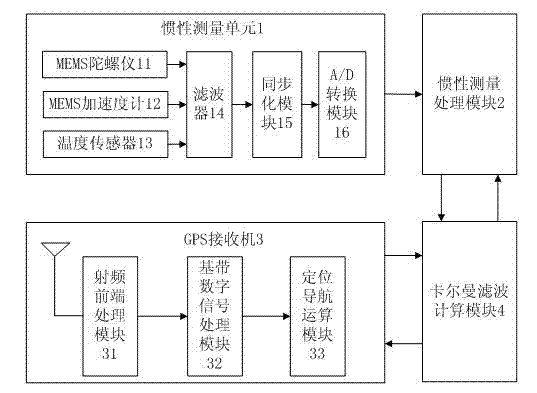
[0021] Such as figure 1As shown, the precise point positioning and inertial measurement tight integrated navigation system of the present invention is mainly composed of an inertial measurement unit 1, an inertial measurement processing module 2, a GPS receiver 3, a Kalman filter calculation module 4 and a power supply module. Among them: the inertial measurement unit 1 is mainly composed of Micro-Electro-Mechanical System (MEMS) sensors, and the inertial measurement unit 1 includes a MEMS gyroscope 11, a MEMS accelerometer 12, a temperature sensor 13, a filter 14, a synchronization The output terminal of MEMS gyroscope 11, MEMS accelerometer 12, temperature sensor 13 is connected in parallel on the filter 14, and filter 14 connects synchronization module 15, and synchronization module 15 connects A / D Conversion module 16. The MEMS gyroscope 11 is a silic...


PUM


Abstract

The invention discloses a precise point positioning and inertia measurement tightly-coupled navigation system and a data processing method thereof. The navigation system comprises an inertia measurement unit, an inertia measurement processing module, a global positioning system (GPS) receiver and a Kalman filtering calculation module. The inertia measurement unit outputs inertia measurement data of a carrier; the inertia measurement processing module receives a digital signal output by the inertia measurement unit, calculates the data of the position, the speed, the gesture and the heading of the carrier through navigation integration, and calculates a pseudo-range, a carrier wave and a carrier wave change rate relative to the inertia measurement unit; the GPS receiver is used for outputting precise point positioning information; the Kalman filtering calculation module receives the output signals of the inertia measurement processing module and the GPS receiver, calculates correction parameters through multi-state Kalman filtering and feeds the correction parameters back to the inertia measurement processing module; and the inertia measurement processing module receives the correction parameters and calculates navigation data. By the system and the method, the defect that GPS signals are weak under the condition that a satellite has a poor geometric structure or in shielded or half-shielded areas is effectively overcome.

Description

technical field [0001] The invention relates to a navigation system and a data processing method thereof, in particular to a precise single-point positioning and inertial measurement tight combination navigation system and a data processing method suitable for transportation tools. Background technique [0002] The navigation of the transport is divided into two categories. (1) Autonomous navigation: use equipment on aircraft or ships to navigate, including inertial navigation, Doppler navigation, and astronomical navigation; (2) Non-autonomous navigation: used for aircraft, ships, automobiles and other transportation equipment and related Ground or air equipment is used for navigation, including radio navigation and satellite navigation. Inertial navigation can achieve autonomy, but its navigation accuracy decreases with time, and satellite navigation accuracy does not change with time, but it requires the input of external signals, which is highly restrictive. [0003] G...

Claims


Application Information

Patent Timeline
Patent Type & Authority Applications(China)
IPC IPC(8): G01S19/49
Inventor 王坚李增科高井祥孟晓林
Owner CHINA UNIV OF MINING & TECH
Why Eureka
Try Eureka