Gravity level surface and global position system (GPS) level difference decomposition and fusion method
A GPS leveling and gravity leveling technology, applied in the field of physical geodesy, which can solve the problems of low resolution, irregular difference shape, and systematic deviation accuracy.
- Summary
- Abstract
- Description
- Claims
- Application Information
AI Technical Summary
Problems solved by technology
Method used
Image
Examples
Embodiment Construction
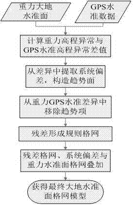
[0015] A new method for merging gravity geoid and GPS level is characterized in that the specific implementation includes the following steps.
[0016] l) Calculation of difference between gravity geoid and GPS level:
[0017] (A) The gravity geoid model is a regular grid, and the GPS leveling is a discrete observation point distributed in any equilibrium, and the coordinates of the GPS leveling points are obtained;
[0018] (B) By the grid interpolation method, the gravity level elevation anomaly of the coordinate position of the GPS benchmarking point is directly interpolated;
[0019] (C) Subtract the calculated elevation anomaly of the gravity level and the elevation anomaly observed by GPS leveling to obtain the difference between the gravity geoid and GPS leveling.
[0020] 2) On the basis of the difference between the gravity level and the GPS level, the trend function of the difference is constructed based on the least square principle, that is...
PUM
 Abstract
Description
Claims
Application Information
 - R&D
- Intellectual Property
- Life Sciences
- Materials
- Tech Scout
- Unparalleled Data Quality
- Higher Quality Content
- 60% Fewer Hallucinations
Browse by: Latest US Patents, China's latest patents, Technical Efficacy Thesaurus, Application Domain, Technology Topic, Popular Technical Reports.
© 2025 PatSnap. All rights reserved.Legal|Privacy policy|Modern Slavery Act Transparency Statement|Sitemap|About US| Contact US: help@patsnap.com


