Automatic efficient full-covering test method of over-the-ground visible light remote sensing satellite image data

A technology for image data and remote sensing satellites, applied in image communication, television, electrical components, etc., can solve problems such as single-byte and single-bit inability to achieve effective detection, limited interpretation means, abnormal image data processing, etc., to achieve test Strong real-time performance, guaranteed full coverage, and efficient utilization

Active Publication Date: 2013-04-03
SHANGHAI SATELLITE ENG INST
View PDF5 Cites 14 Cited by
  • Summary
  • Abstract
  • Description
  • Claims
  • Application Information

AI Technical Summary

Problems solved by technology

[0013] Both of the above two test methods adopt post-interpretation, or extract part of the image for naked eye observation for data detection. Due to the large amount of image data and limited interpretation methods, only obvious abnormalities and errors in imag

Method used


Image

  • Automatic efficient full-covering test method of over-the-ground visible light remote sensing satellite image data
  • Automatic efficient full-covering test method of over-the-ground visible light remote sensing satellite image data
  • Automatic efficient full-covering test method of over-the-ground visible light remote sensing satellite image data

Examples


Example Embodiment

[0063] The embodiments of the present invention are described in detail below: the present embodiment is implemented on the premise of the technical solution of the present invention, and provides a detailed implementation manner and a specific operation process, but the protection scope of the present invention is not limited to the following implementations example.

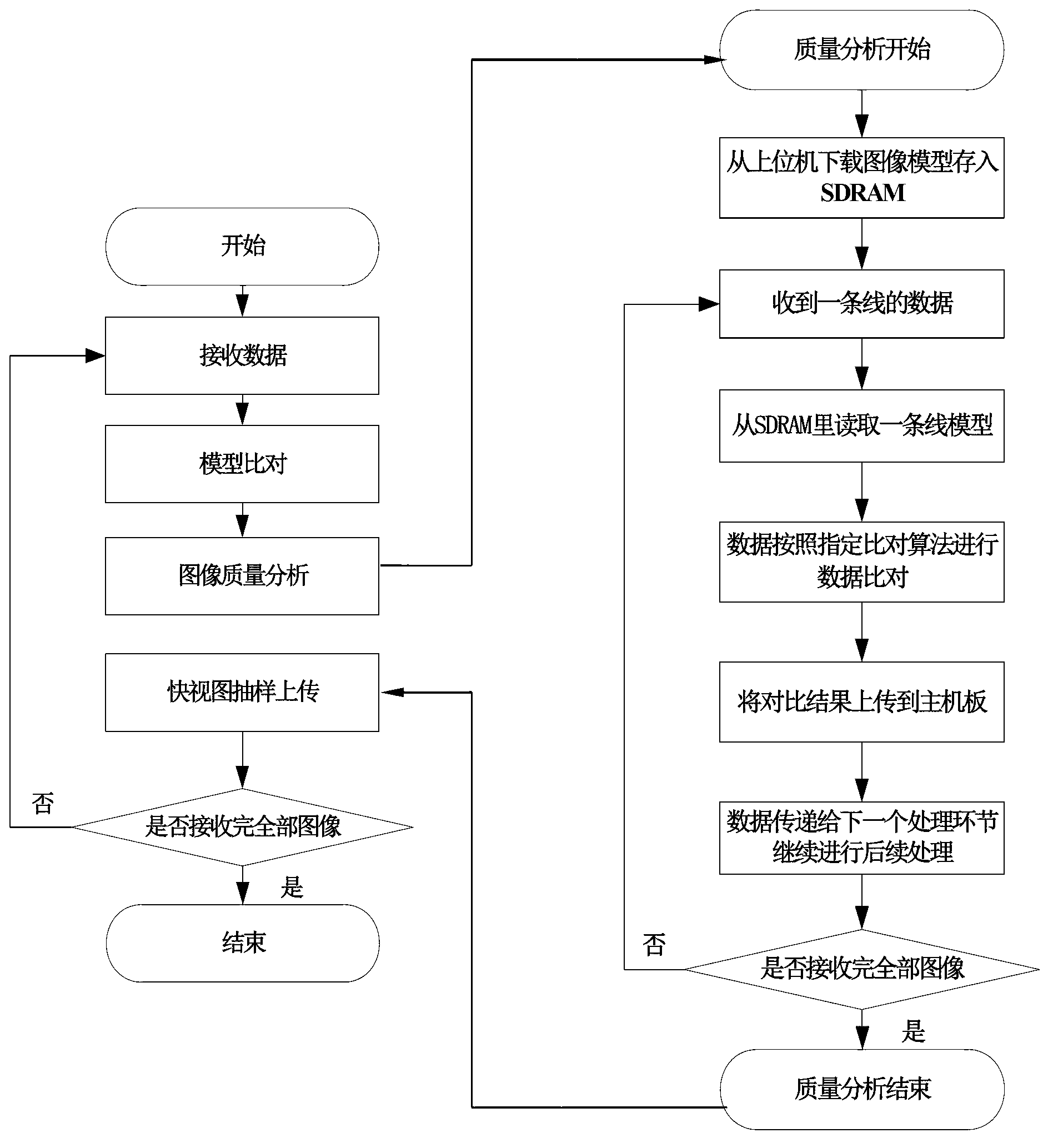
[0064] figure 2 Shown is a flow chart of the automatic, efficient, and full coverage testing method for ground visible light remote sensing satellite image data provided according to an embodiment of the present invention. Specifically, in this embodiment, the following steps are included:

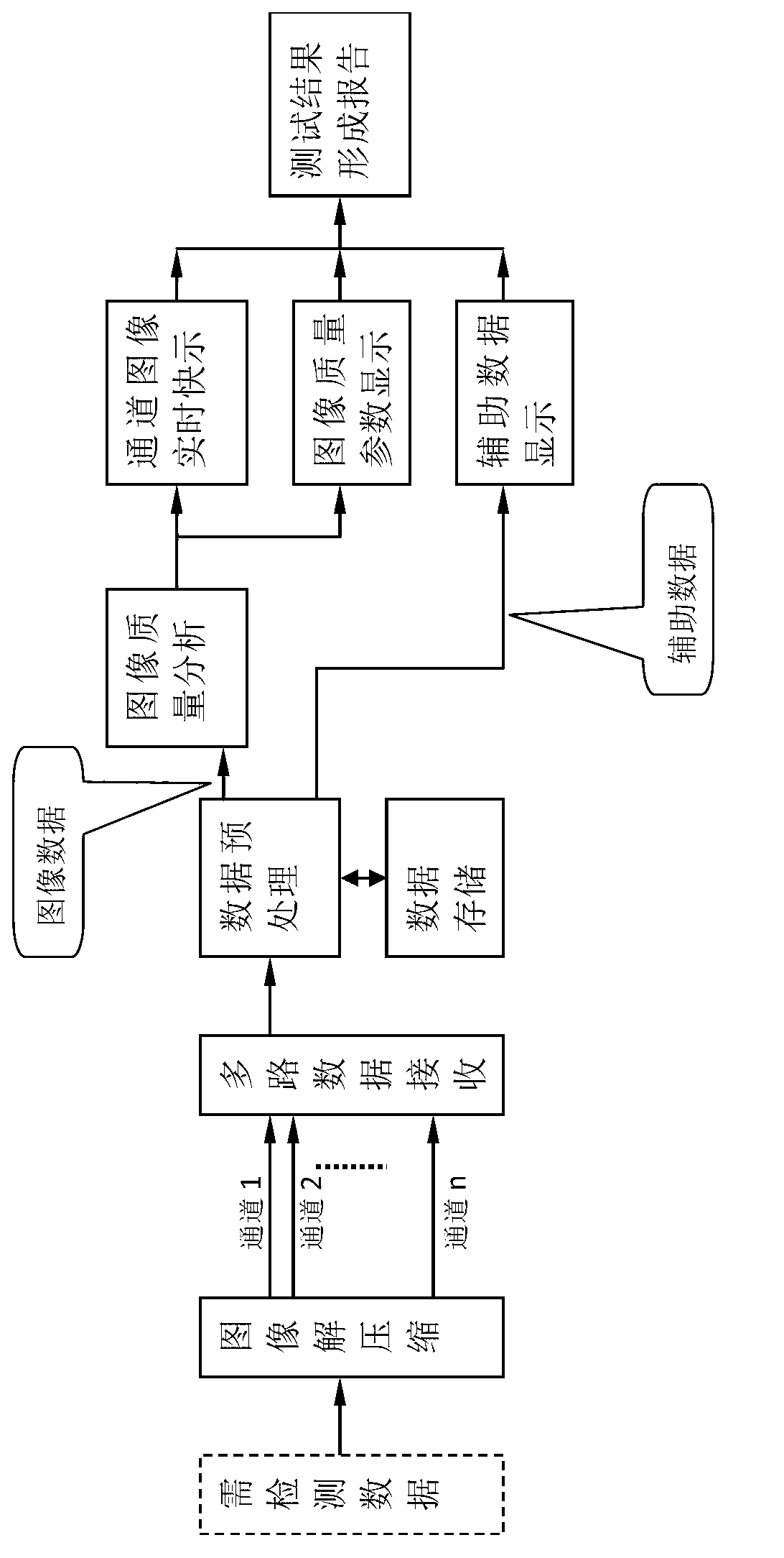
[0065] Step (1): Receive the image data to be detected in real time, and perform real-time data decompression processing.

[0066] Step (2): Divide the decompressed image data by channel.

[0067] Step (3): Perform image data preprocessing on the decompressed image data according to the channel, specifically: accumulati...


PUM


Abstract

The invention discloses an automatic efficient full-covering test method of over-the-ground visible light remote sensing satellite image data. The automatic efficient full-covering test method includes: timely receiving data needing detection and performing real-time data uncompressing; performing image data dividing for the uncompressed image data according to channels; performing image data preprocessing for the uncompressed image data according to channels; separating auxiliary data in a channel image data packet; timely storing continuous test samples and playing back the test samples as required; performing image quality testing and performing image data quick looking according to the channels; and displaying the testing result and automatically forming a testing report. Simultaneously, the automatic efficient full-covering test method has the capabilities of image data postmortem analysis processing and open type function extensibility, and has the automatic, efficient and full-covering advantages.

Description

technical field [0001] The invention relates to a whole-satellite test scheme for high-resolution satellite image data, and more specifically, to a design method for a test scheme for visible light imaging satellite load image data. Background technique [0002] Optical remote sensing satellites have been widely used in many fields such as my country's economic construction, environmental monitoring, land survey, disaster emergency response and rescue. All major aerospace countries have invested heavily in the development of their own optical remote sensing satellites, and our country has also continuously increased investment in research. Optical remote sensing satellites are characterized by larger and larger remote sensing swaths, higher resolutions, and larger data volumes. Therefore, the requirements for correctness detection of image data are getting higher and higher in the process of satellite development. [0003] The data to be detected includes the following con...

Claims


Application Information

Patent Timeline
IPC IPC(8): H04N17/00
Inventor 叶晖李博杨炳轲魏致坤周徐斌
Owner SHANGHAI SATELLITE ENG INST
Why Eureka
Try Eureka