
Indoor route navigation method based on mixed reality

A path navigation and mixed reality technology, applied in directions such as navigation, mapping and navigation, measurement devices, etc., can solve the problem of inability to display the location in three-dimensional, solve real-time and jitter problems, improve accuracy, and enhance adaptive light intensity. the effect of the ability

Active Publication Date: 2015-10-21
HEFEI INSTITUTES OF PHYSICAL SCIENCE - CHINESE ACAD OF SCI
View PDF6 Cites 1 Cited by
  • Summary
  • Abstract
  • Description
  • Claims
  • Application Information

AI Technical Summary

Problems solved by technology

However, the patent imaging can only be displayed in a plane, and cannot display the location in a three-dimensional manner

Method used


Image

  • Indoor route navigation method based on mixed reality
  • Indoor route navigation method based on mixed reality
  • Indoor route navigation method based on mixed reality

Examples


Embodiment Construction

[0025] The present invention will be further described below in conjunction with the accompanying drawings and specific embodiments.

[0026] The present invention is a navigation system based on monocular vision positioning, relying on real-time registration scene to complete fast tracking of virtual navigation information and real-time rendering of indoor path. The precise location positioning method and the scene configuration method of the indoor route navigation system are introduced below.

[0027] The indoor route navigation system includes a mobile terminal, the mobile terminal includes a mobile camera and a display screen, a wireless local area network, a remote server, a remote PC, and a location structure model library is set in the remote PC, which will pre-record the location structure in the indoor building Featured in the picture, the remote PCs are connected via a wired network.

[0028] First, the user inputs the destination in the mobile terminal; the camera...


PUM


Abstract

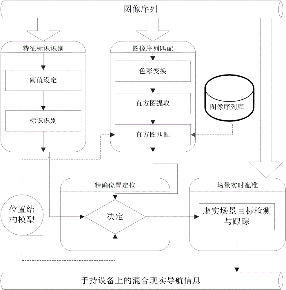
The invention discloses an indoor path navigation method based on mixed reality, wherein a mobile terminal, a wireless local area network, a remote server, and a plurality of remote PC are provided, the mobile terminal comprises a mobile camera and a display screen, and the plurality of the remote PC are connected via a wired network. The method is characterized by comprising the following steps that: 1) a destination is input on the mobile terminal, and the destination is transmitted to the remote PC through the wireless local area network; 2) the mobile terminal forms an image sequence according to a current image captured by the camera, and transmits the image sequence to the remote PC through the wireless local area network; 3) the remote PC sequentially performs three steps such as reliable identification labeling, image sequence matching and position model screening according to the received image sequence to calculate current position information of a user; and 4) the remote PC calculates and forms path navigation according to the current position information of the user and the destination, overlays the path navigation by using a mixed reality technology in a 3D manner, and feeds the overlaid path navigation back to the display screen of the mobile terminal through the wireless local area network.

Description

technical field [0001] The invention designs an indoor path navigation method based on mixed reality, and belongs to the field of path navigation. technical background [0002] With the rapid development of urban construction, all kinds of modern high-rise buildings are crowded with each other, and their internal structures and functions are intricate. When people are in such strange and complex environments and need to find specific goals, such as office buildings, exhibition halls, In indoor areas such as campuses, hospitals, museums, concerts, technical conferences, and large-scale exhibitions, indoor path navigation is particularly important at this time—guiding users who are not familiar with the place to find the route to the destination, and indoor crowds in emergencies Rapid evacuation and emergency rescue, etc. [0003] Chinese patent application No. CN200810060078.7 "Indoor Positioning Method Based on Wireless Sensor Network" discloses a hybrid indoor positioning ...

Claims


Application Information

Patent Timeline
Patent Type & Authority Patents(China)
IPC IPC(8): G01C21/00
Inventor 宋小波李芬刘百辰周培莹赵江海何锋王敏
Owner HEFEI INSTITUTES OF PHYSICAL SCIENCE - CHINESE ACAD OF SCI
Learn More