Method for extracting road alignment parameters

A road and alignment technology, applied in the field of extracting road alignment parameters, can solve problems such as no mature technology

Inactive Publication Date: 2013-09-18
NAVINFO
View PDF3 Cites 22 Cited by
  • Summary
  • Abstract
  • Description
  • Claims
  • Application Information

AI Technical Summary

Problems solved by technology

[0005] The technical problem to be solved by the present invention is to provide a method for extracting the linear parameters of the road, which is used to solve the defect that there is no mature technology to extract the optimal linear parameters in the data collection and processing of the existing navigation electronic map

Method used


Image

  • Method for extracting road alignment parameters
  • Method for extracting road alignment parameters
  • Method for extracting road alignment parameters

Examples


Embodiment Construction

[0026] In order to make the technical problems, technical solutions and advantages to be solved by the present invention clearer, the following will describe in detail with reference to the drawings and specific embodiments.

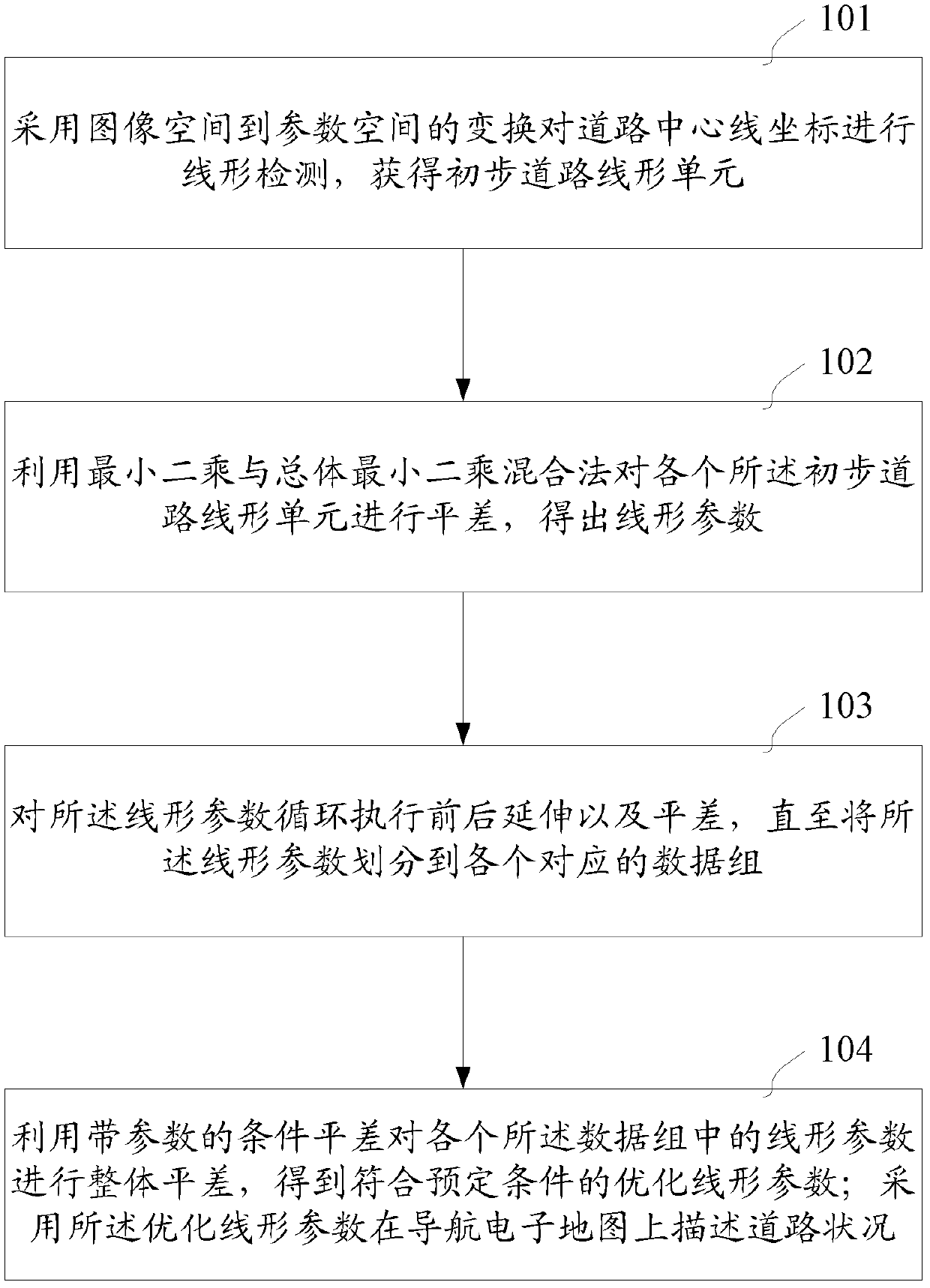
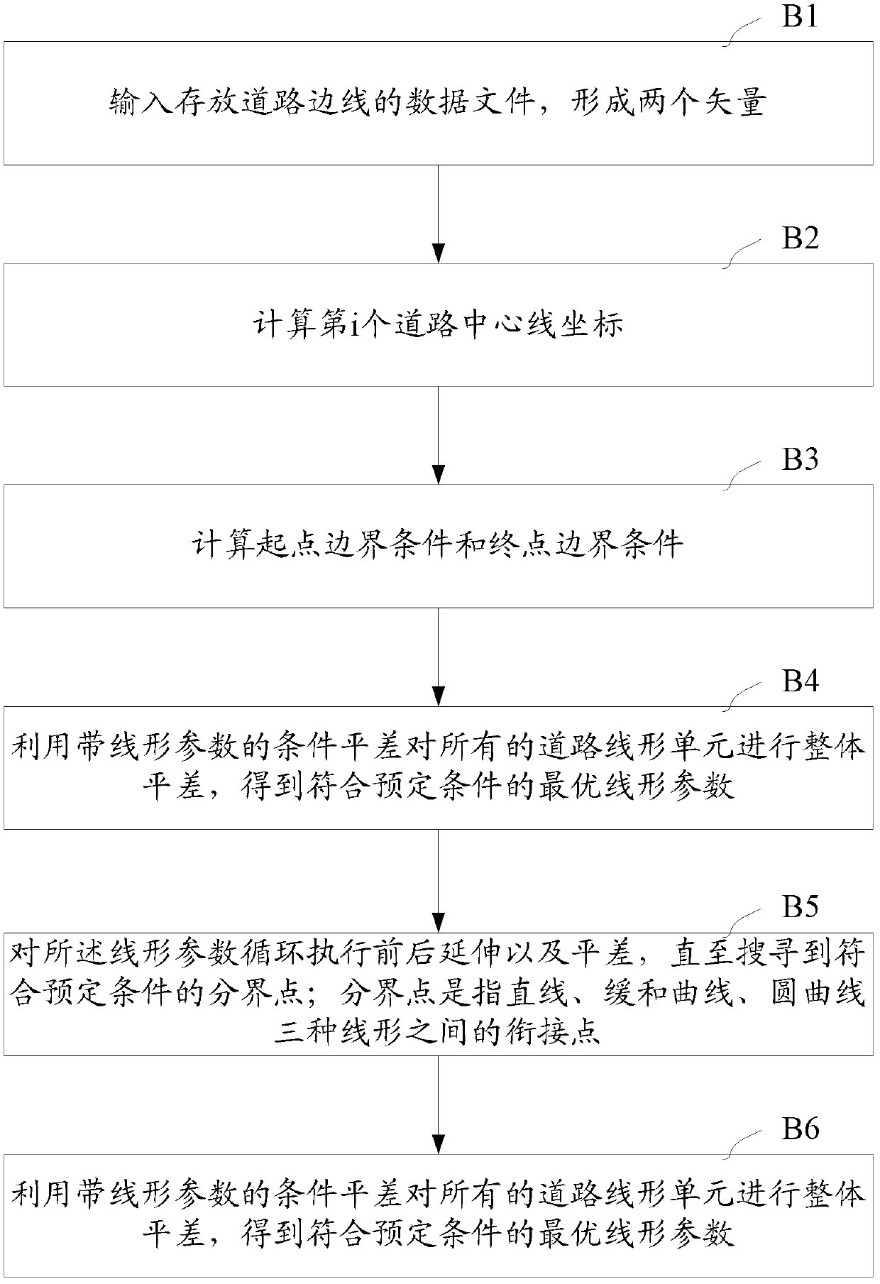
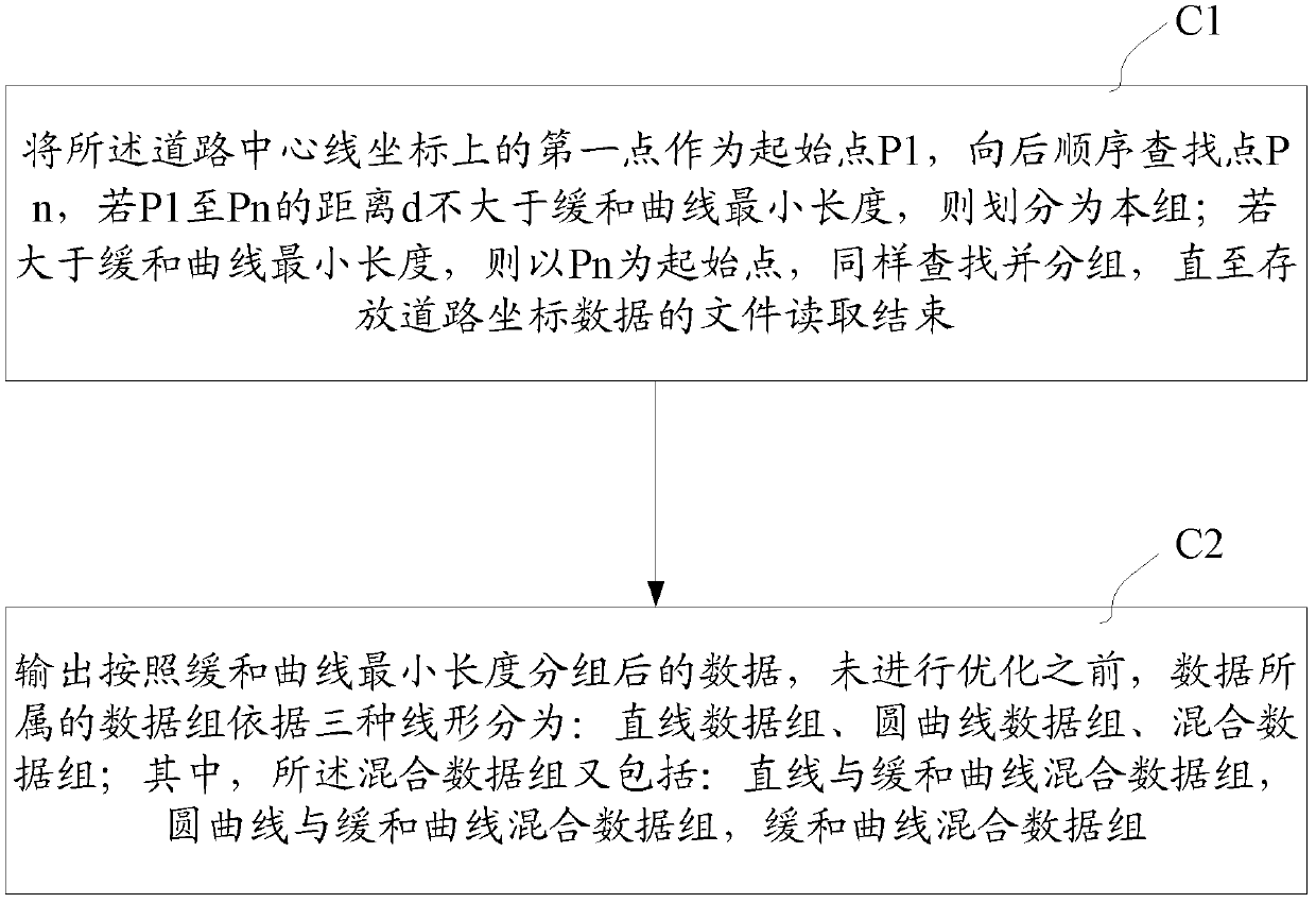
[0027] During the road design process, the alignment of the road on the electronic map should be one of three alignments: straight line, transitional curve, and circular curve. According to the coordinates of the starting point and end point of the road, azimuth, alignment parameters, and road width, it can be accurately calculated. The coordinates of any point on the road can be used to obtain information such as the tangent direction of any point. Linear parameters are important navigation data, which are used to describe roads, reduce the data volume of electronic maps, optimize the expression and description of roads on electronic maps, and make electronic maps more refined. In automatic driving, when the expressway turns from a straight line to a ge...


PUM


Abstract

The embodiment of the invention provides a method for extracting road alignment parameters. The method is applied to a navigation unit and comprises the steps of: step 1, linearly detecting a road axis coordinate to obtain preliminary road alignment units by adopting a conversion between an image space and a parameter space; step 2, utilizing a mixing method of a least square and a total least square to carry out adjustment on the preliminary road alignment units so as to obtain linear parameters; step 3, circularly executing forward and backward extension and adjustment on the linear parameters until the linear parameters are divided into corresponding data sets; and step 4, utilizing a condition adjustment with parameters to carry out overall adjustment on the linear parameters in the data sets so as to obtain the optimized linear parameters according with preset conditions; and adopting the optimized linear parameters to describe road conditions in a navigation electronic map. The road conditions can be accurately described on the navigation electronic map through the optimized linear parameters.

Description

technical field [0001] The invention relates to electronic map technology, in particular to a method for extracting road linear parameters. Background technique [0002] Road information in navigation technology is very important. Improving the accuracy of road information, refinement, and improving the automation of obtaining geometric characteristics are important technical directions for making navigation maps. In road design, there are three types of road alignment: straight line, circular curve, and transitional curve. Generally, according to the road grade, the transitional curve has a minimum length value. According to the coordinates and azimuth angles of the starting point and end point of the road, combined with the linear parameters and road width, the coordinates of any point on the road can be accurately calculated, and information such as its tangent direction can be obtained. [0003] Roads in electronic navigation maps are generally represented by arcs (Link...

Claims


Application Information

Patent Timeline
Patent Type & Authority Applications(China)
IPC IPC(8): G09B29/00G01C21/26
Inventor 康传利
Owner NAVINFO
Why Eureka
Try Eureka