High resolution tracking of mobile assets

a mobile asset and high resolution technology, applied in the direction of navigation instruments, instruments, process and machine control, etc., can solve the problems of insufficient detail or precise reference features of above-mentioned landmarks to provide a high-resolution description of asset location, difficulty in finding single trailers or containers, and consideration of appropriate reference, so as to facilitate accurate association of assets with landmarks, the effect of reducing the burden on users

Inactive Publication Date: 2005-07-19
ASSET INTELLIGENCE
View PDF3 Cites 68 Cited by
  • Summary
  • Abstract
  • Description
  • Claims
  • Application Information

AI Technical Summary

Benefits of technology

[0009]The present invention provides graphical and programmatic methods for highly accurate description and display of landmarks. An accurate association of assets with the landmarks is facilitated. In addition, these advantages are provided with a minimum burden on users to set up or maintain data. These methods are highly effective in providing high resolution asset tracking with high value to users.

Problems solved by technology

However, the geo-reference features and landmarks described above are not sufficiently precise or detailed to provide a high resolution description of the asset location.
In these cases, without a proper geo-reference landmark or feature, finding a single trailer or container is a challenge that takes a significant amount of time.
Although the accuracy of GPS coordinates now supports more accurate description of where a particular asset is, the problem of appropriate referencing must be considered.
Without detailed local area geo-reference characteristics or landmarks that have the same or better degree of accuracy as the asset coordinates, it is difficult to create a high resolution description of the asset location.

Method used


Image

  • High resolution tracking of mobile assets
  • High resolution tracking of mobile assets
  • High resolution tracking of mobile assets

Examples


Embodiment Construction

[0019]A description of preferred embodiments of the invention follows.

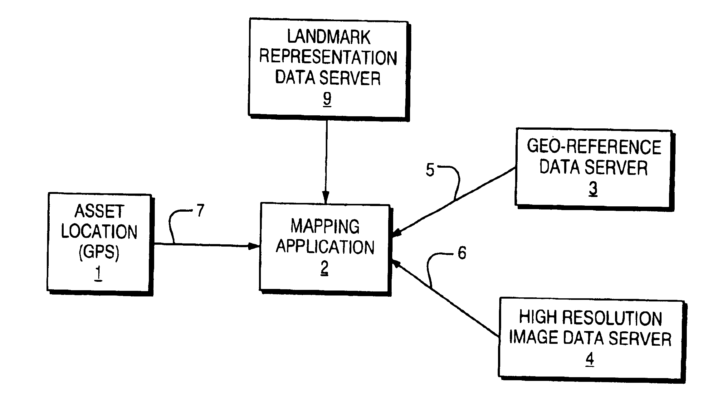
[0020]FIG. 1 is a block diagram illustrating a high resolution asset tracking system according to the present invention. The high resolution asset tracking system includes an asset location system 1, such as the Global Positioning System (GPS), to provide the coordinates 7 of an asset, a geo-reference data server 3 to provide geo-reference data 5 of well known features and landmarks, a geo-image data server 4 to provide geo-image data 6 of high resolution geo-images, and a landmarks representation data server 9. The high resolution asset tracking system also includes a mapping application 2 integrating the coordinates of the asset and the data from geo-reference data server 3 and geo-image data server 4, to provide a high resolution description of asset location.

[0021]The geo-image data 6 provides more detailed reference information than geo-reference data 5. The geo-image data 6 is integrated with the coordinates...


PUM


Abstract

A system and method for describing local area geo-reference features and landmarks in providing high resolution asset location information. Geo-image data is integrated to a mapping application and geo-reference data to add more detailed scale levels to the map. The geo-image data includes geo-images and its features to provide more detailed references to the asset and support the larger references of the geo-reference data. To describe a geo-reference landmark, an original landmark representation is selected with a center point and a radius. The asset location points located at the original landmark representation are compiled along with the asset location points generated by events occurring at the landmark to create a point set. The point set replaces the original landmark representation when a prescribed number of points is reached. The asset location points that are within a specified distance from any of the points in the point set are added to the point set to complete the landmark representation. The geo-image data and landmark representation data are combined to provide high resolution asset location information.

Description

RELATED APPLICATION[0001]This application claims the benefit of U.S. Provisional Application No. 60 / 318,738, filed Sep. 12, 2001. The entire teachings of the above application are incorporated herein by reference.BACKGROUND OF THE INVENTION[0002]Tracking assets using Global Positioning System (GPS) technology is becoming widely used. However, for most users, latitudinal and longitudinal coordinates are generally not a very useful form of location information. Instead, it is more useful for users to have the coordinates provided in reference to one or more features or landmarks that are commonly known.[0003]In most regions of the world, there exists so-called “geo-reference data” that provides the coordinates of well known features and landmarks, such as roads, rail lines, topology, land use and place descriptions. By combining the coordinates of a tracked asset with information about nearby geo-reference features and landmarks a useful description of the asset location can be create...

Claims


Application Information

Patent Timeline
Patent Type & Authority Patents(United States)
IPC IPC(8): G01C21/30G01C21/28G01C21/26G06T17/05
CPCG06T17/05
Inventor DAUBERT, ROBERT H.DOYLE, THOMAS F.
Owner ASSET INTELLIGENCE
Why Eureka
Try Eureka