Quick-look client combined with three-dimensional earth

A three-dimensional earth and satellite technology, applied in the field of Kuaishou client, can solve problems such as unfavorable satellite image interpretation and delay

Active Publication Date: 2013-09-25
CHINA CENT FOR RESOURCES SATELLITE DATA & APPL
View PDF5 Cites 6 Cited by
  • Summary
  • Abstract
  • Description
  • Claims
  • Application Information

AI Technical Summary

Benefits of technology

The present in this patented technology allows for combining data from different sources like an airborne radar system or a ground based navigation device (GNS) into one single file that shows both its own coordinate space and orientation within it. This makes understanding about how things are located can be quicker than just looking through multiple documents containing these two types of data separately.

Problems solved by technology

This patented describes an improved method for acquiring high resolution maps that include both spatial and temporal aspects related to space exploration technology used over Earth observing systems like X-ray observatories. However, there currently exist challenges when analyzing these maps because it requires manual intervention and analysis tools.

Method used


Image

  • Quick-look client combined with three-dimensional earth
  • Quick-look client combined with three-dimensional earth

Examples


Embodiment Construction

[0018] Below in conjunction with accompanying drawing, the present invention is described in detail, specifically as follows:

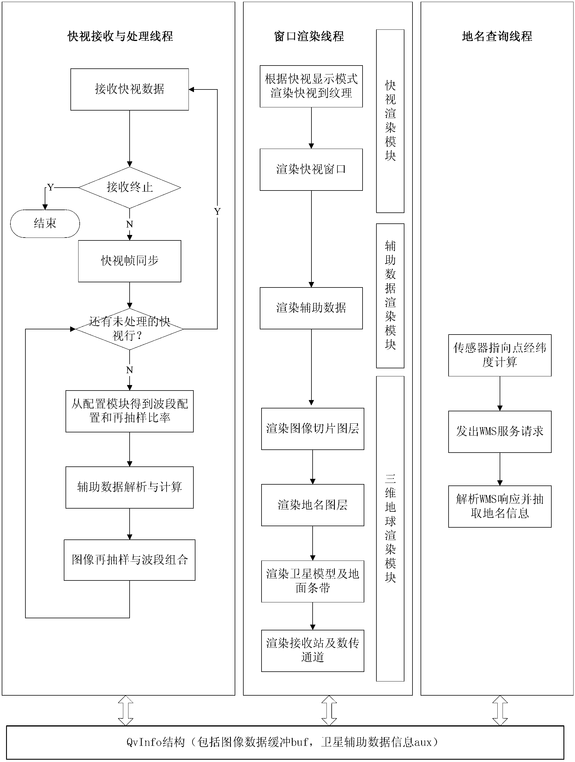
[0019] The invention relates to a quick view client combined with a three-dimensional earth, including three threads, a configuration module and a structure; the three threads are respectively a data receiving and processing thread, a window rendering thread, and a place name query thread. A self-defined structure for information exchange. For the convenience of introduction, this structure is named QvInfo; each part is described in detail below:

[0020] (1) QvInfo structure

[0021] The QvInfo structure includes buffer buf and aux structure; the buffer buf is used to store the image data processed by the data receiving and processing thread, and the aux structure is used to store the satellite auxiliary data information processed by the data receiving and processing thread and the information obtained by the place name query thread place name infor...


PUM


Abstract

A quick-look client combined with the three-dimensional earth comprises a data receiving and processing thread, a window rendering thread and a geographical name inquiring thread. The threads performs information exchange with one another through a QvInfo structure. A configuration module reads information from a configuration file and provide the information to the three threads. The data receiving and processing thread receives quick-look data, performs resampling to the received images, analyzes satellite auxiliary data, and stores the processed data in the QvInfo structure. The geographical name inquiring thread calculates longitude and latitude of a point pointed by an optical axis of a sensor, transmits the longitude and latitude to a WMS (web mapping service), receives a GetInfo data structure fed back by the WMS, analyzes the GetInfo data structure to obtain the geographical name information corresponding to the longitude and latitude, and stores the geographical name information in the QvInfo structure. The window rendering thread renders the image data, the satellite auxiliary data information and the geographical name information, calculates poses and positions of a satellite three-dimensional model in the three-dimensional earth, and completes rendering of the satellite three-dimensional model in the three-dimensional earth.

Description


Claims


Application Information

Patent Timeline
Owner CHINA CENT FOR RESOURCES SATELLITE DATA & APPL
Why Eureka
Try Eureka