Integrated navigation method based on satellite navigation and inertial navigation

An integrated navigation and inertial navigation technology, applied in the field of integrated navigation, can solve the problem of no receiver improvement, and achieve the effect of improving the anti-noise interference ability, improving the robustness and reliability, and enhancing the anti-noise interference ability.

Inactive Publication Date: 2014-04-23
BEIHANG UNIV
View PDF5 Cites 16 Cited by
  • Summary
  • Abstract
  • Description
  • Claims
  • Application Information

AI Technical Summary

Problems solved by technology

However, this solution not only does not introduce inertial navigation information to assist the satellite receiver, but also does not make any improvements to the receiver

Method used


Image

  • Integrated navigation method based on satellite navigation and inertial navigation
  • Integrated navigation method based on satellite navigation and inertial navigation
  • Integrated navigation method based on satellite navigation and inertial navigation

Examples


Embodiment Construction

[0045] The present invention will be further described below in conjunction with the accompanying drawings and specific embodiments.

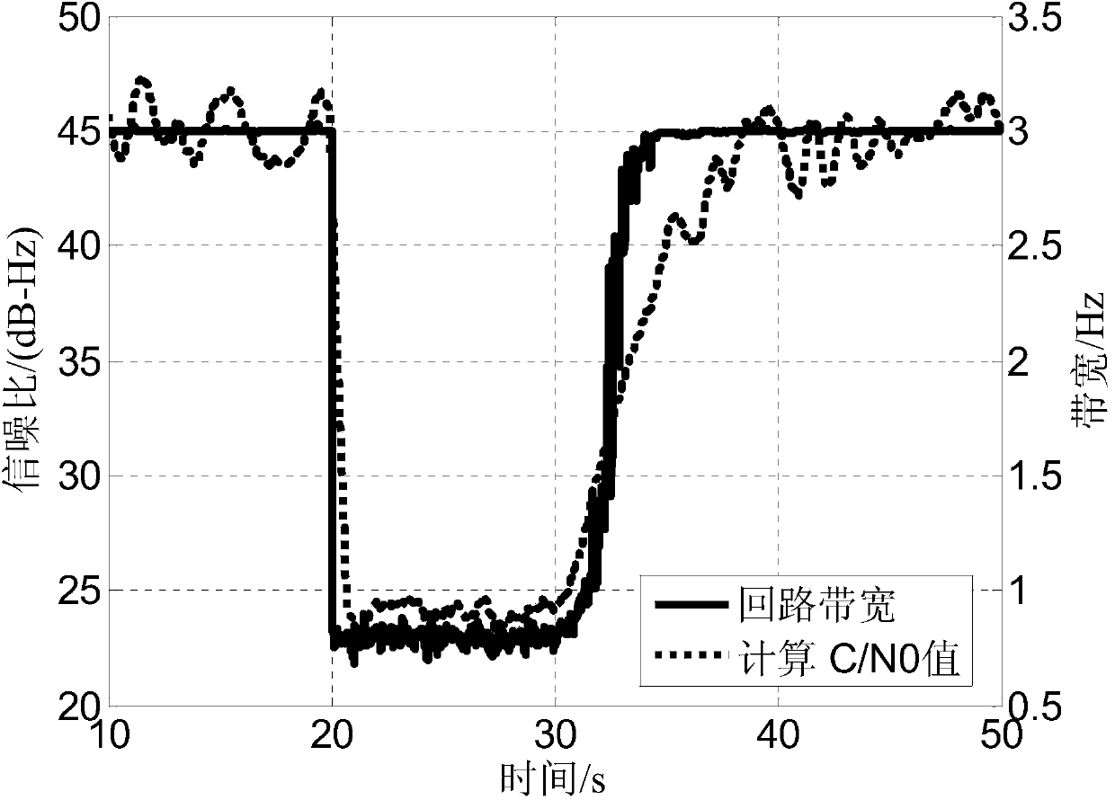
[0046] First of all, the adaptive adjustment of the bandwidth of the satellite signal receiver is realized through the fuzzy reasoning system which takes the signal-to-noise ratio (ie C / N0) of the satellite signal as the input. If the signal-to-noise ratio decreases, it means that the noise becomes larger, and the phase-locked loop bandwidth of the satellite receiver should be reduced to obtain a better filtering effect, that is, a stronger ability to resist noise interference; if the signal-to-noise ratio increases, it means that the noise becomes smaller, In order to obtain better dynamic performance, the bandwidth of the phase-locked loop of the satellite receiver should be increased accordingly. Since there is no clear mathematical relationship between signal-to-noise ratio and bandwidth, and there is no unique optimal value of PLL bandwidt...


PUM


Abstract

The invention discloses an integrated navigation method based on satellite navigation and inertial navigation. The method can maintain higher navigation precision under the conditions of lower signal-noise ratio of satellite signals and greater noise change, and has two main characteristics that firstly, a bandwidth self-adaption satellite signal receiver based on a fuzzy inference system is adopted, and secondly, an integrated navigation algorithm for noise model self-adaption measurement on the basis of the fuzzy inference system is adopted. After the functions are added to the original integrated navigation system structure basis, the integrated navigation method has the advantages that higher navigation precision is maintained under the conditions of lower signal-noise ratio of the satellite signals and greater noise change, and the anti-noise-jamming capability is obviously enhanced.

Description

technical field [0001] The invention relates to the technical field of integrated navigation, in particular to an integrated navigation method based on satellite navigation and inertial navigation. Background technique [0002] In recent years, the integrated navigation technology of satellite navigation and inertial navigation has developed rapidly and matured day by day. Especially in recent years, with the rapid advancement of inertial device technology, low-cost, high-reliability, and high-precision inertial devices are more common, and the use of inertial devices or inertial navigation systems (INS) to assist satellite navigation has gradually become an important part of integrated navigation research. trends and hotspots. The use of inertial navigation (inertial navigation) information to assist satellite navigation receivers to capture satellites and track signals can greatly increase the receiver's ability to respond to dynamics, and at the same time reduce the band...

Claims


Application Information

Patent Timeline
Patent Type & Authority Applications(China)
IPC IPC(8): G01S19/49G01S19/47G01C21/16
CPCG01S19/49G01C21/165
Inventor 王学运张京娟王蕾高鹏宇
Owner BEIHANG UNIV
Why Eureka
Try Eureka