Method for splicing ZY3 satellite three-line-scanner image and multispectral image

A multi-spectral image and ZY-3 technology, which is applied in the field of splicing of ZY-3 satellite three-line array images and multi-spectral images, can solve the problems of splicing errors, insufficient reliability of matching points with the same name, and inability to eliminate high-frequency noise.

Active Publication Date: 2014-07-09
SATELLITE SURVEYING & MAPPING APPL CENTSASMAC NAT ADMINISTATION OF SURVEYING MAPPING & GEOINFORMATION OF CHINANASG
View PDF2 Cites 24 Cited by
  • Summary
  • Abstract
  • Description
  • Claims
  • Application Information

AI Technical Summary

Problems solved by technology

However, in fact, during the flight of the satellite, in order to maintain the stability of the three axes, the attitude control system will continuously adjust the attitude of the satellite. Due to the existence of these factors, there will be high-frequency jitter in the attitude of the satellite, which will cause the CCD not located in the same line. There will be a phenomenon of inconsistency in imaging time between , this phenomenon is called high-frequency noise of satellite attitude, this high-frequency noise cannot be eliminated by a simple low-order model
Moreover, image stitching based on image squares is heavily dependent on the accuracy of point matching of the same name. Once the texture of the stitching point is single and the reliability of point matching of the same name is insufficient, stitching errors will occur.
In addition, the more serious problem is that the image produced by this stitching method loses the strict imaging geometric model
If the general sensor model, such as RFM (Rational Function Model, rational polynomial model) is directly used to replace the original model, there will be a problem of low model replacement accuracy, such as the 1B product of ALOS (Japanese Earth Observation Satellite)

Method used


Image

  • Method for splicing ZY3 satellite three-line-scanner image and multispectral image
  • Method for splicing ZY3 satellite three-line-scanner image and multispectral image
  • Method for splicing ZY3 satellite three-line-scanner image and multispectral image

Examples


Embodiment Construction

[0036] The present invention will be described in detail below in conjunction with the accompanying drawings and embodiments.

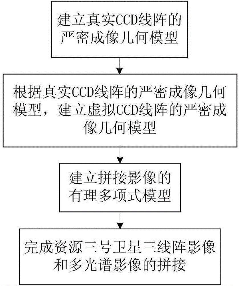
[0037] Such as figure 1 As shown, the mosaic method of the three-line array image and the multi-spectral image of the No. 3 satellite of the present invention specifically includes the following steps:

[0038] 1) Establish a rigorous imaging geometric model of the real CCD line array;

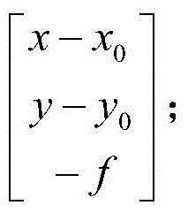
[0039] ① Use the principal point of the panchromatic or multispectral camera (x 0 ,y 0 ), like the main distance f, the size of the pixel (x, y), and determine the coordinates of the pixel (x, y) in the panchromatic or multispectral camera coordinate system as:

[0040] x - x 0 y - y 0 ...


PUM


Abstract

The invention relates to a method for splicing a ZY3 satellite three-line-scanner image and a multispectral image. The method includes the following steps of building a precise imaging geometrical model of a real CCD linear array, building a precise imaging geometrical model of a virtual CCD linear array according to the precise imaging geometrical model of the real CCD linear array, building a rational polynomial model of the spliced images, and finishing splicing of the ZY3 satellite three-line-scanner image and the multispectral image. By the inner view field splicing scheme based on the virtual CCD linear array, a distortionless CCD array is built on a focal plane, and reimaging is carried out on a plurality of original CCD imaging images according to a line central projection imaging method, so that line central projection seamless splicing of the CCD imaging images is achieved. The method can be widely applied to image processing of the ZY3 satellite.

Description

technical field [0001] The invention relates to an image splicing method, in particular to a splicing method of the three-line array image and the multi-spectral image of the Ziyuan No. 3 satellite. Background technique [0002] In the design of a high-resolution optical linear array push-broom satellite camera, in order to obtain a larger frame width, multiple CCD (Charge-coupled Device, charge-coupled device) line arrays are installed alternately on the focal plane. A continuous CCD array that forms an approximate straight line. However, due to the limitation of the installation accuracy of multiple CCD line arrays and the width of TDI-CCD (Time Delayed and Integration Charge-coupled Device) along the track direction, it is impossible for multiple CCD line arrays to Form a strict sense of the CCD line array. In the production of photogrammetry data, images stitched according to the imaging geometric characteristics and radiation characteristics provided by satellite imag...

Claims


Application Information

Patent Timeline
Patent Type & Authority Applications(China)
IPC IPC(8): G06T3/40
Inventor 张过唐新明蒋永华高小明祝小勇胡芬方辰邓明军
Owner SATELLITE SURVEYING & MAPPING APPL CENTSASMAC NAT ADMINISTATION OF SURVEYING MAPPING & GEOINFORMATION OF CHINANASG
Why Eureka
Try Eureka