Electronic map matching method and device

An electronic map and matching method technology, applied in the field of intelligent transportation, can solve the problems of low time complexity, long matching time, and less consideration of the overall trend of the trajectory, so as to improve the matching efficiency and reduce the matching error.

Active Publication Date: 2014-09-03
TENCENT TECH (SHENZHEN) CO LTD +1
View PDF8 Cites 10 Cited by
  • Summary
  • Abstract
  • Description
  • Claims
  • Application Information

AI Technical Summary

Problems solved by technology

[0005] In the electronic map matching method of the prior art, the method with higher matching accuracy generally has more complex algorithms, high time complexity, and long matching time; The trend is considered less, and the matching accuracy is relatively low in the case of complex road networks

Method used


Image

  • Electronic map matching method and device
  • Electronic map matching method and device
  • Electronic map matching method and device

Examples


Embodiment 1

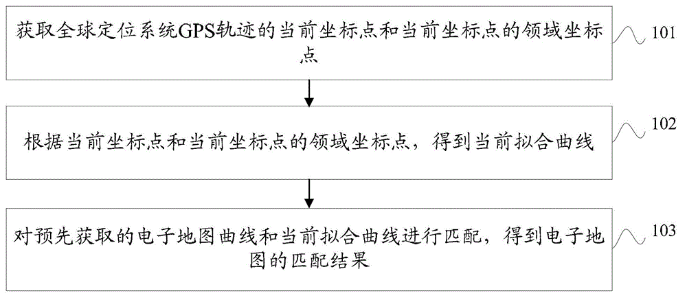
[0049] see figure 1 , an embodiment of the present invention provides a method for matching an electronic map, the method comprising:

[0050] 101. Obtain the current coordinate point of the GPS track of the global positioning system and the neighborhood coordinate points of the current coordinate point;

[0051] 102. Obtain the current fitting curve according to the current coordinate point and the neighborhood coordinate points of the current coordinate point;

[0052] 103. Match the pre-acquired electronic map curve and the current fitting curve to obtain a matching result of the electronic map.

[0053] Specifically, according to the current coordinate point and the neighbor coordinate points of the current coordinate point, the current fitting curve is obtained, including:

[0054] According to the current coordinate point and the neighbor coordinate points of the current coordinate point, the least square plane is fitted; the least square plane is the plane with the sm...

Embodiment 2

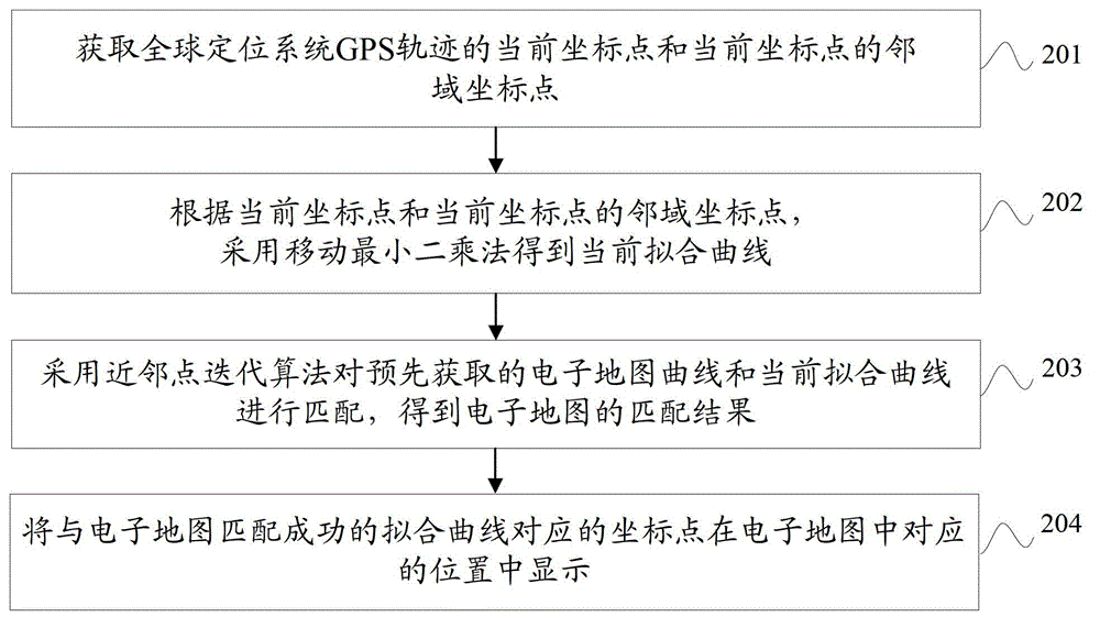
[0067] see figure 2 , an embodiment of the present invention provides a method for matching an electronic map, the method comprising:

[0068] 201. Obtain the current coordinate point of the GPS track of the global positioning system and the neighborhood coordinate points of the current coordinate point;

[0069] Specifically, the neighborhood coordinate point in the embodiment of the present invention refers to the coordinate point of the GPS track adjacent to the current coordinate point according to the preset requirements, for example, the 10 coordinate points adjacent to the current coordinate point are used as the neighborhood coordinates Points; the number of acquired neighborhood coordinate points is different for different precision requirements.

[0070] Electronic map matching is to match the vehicle's GPS track with the vectorized road section on the electronic map, find the current driving road, and project the vehicle's GPS positioning point onto the electronic...

Embodiment 3

[0090] see Figure 5 , an embodiment of the present invention provides an electronic map matching device, the device includes:

[0091] Obtaining module 501, for obtaining the current coordinate point of the GPS track of the global positioning system and the neighborhood coordinate points of the current coordinate point;

[0092] The fitting module 502 is used to obtain the current fitting curve by using the moving least squares method according to the current coordinate point and the neighborhood coordinate points of the current coordinate point;

[0093] The matching module 503 is configured to use the neighbor point iterative algorithm to match the electronic map curve acquired in advance with the current fitting curve to obtain a matching result of the electronic map.

[0094] Specifically, see Image 6 , a fitting module 502, comprising:

[0095] The plane fitting unit 502a is used to fit the least squares plane according to the current coordinate point and the neighbo...


PUM


Abstract

The invention discloses an electronic map matching method and device and belongs to the field of intelligent transportation. The method comprises the following steps: acquiring a current coordinate point of the track of a global positioning system (GPS) and a neighboring coordinate point of the current coordinate point; obtaining a current fitted curve according to the current coordinate point and the neighboring coordinate point thereof; and matching an electronic map curve which is obtained in advance with the current fitted curve, thereby obtaining a matching result of the electronic map. The problems that a conventional electronic map matching method is complex in algorithm, long in time, high in complexity and relatively low in matching precision are solved, the matching efficiency is improved, and the matching error is reduced.

Description

technical field [0001] The invention relates to the field of intelligent transportation, in particular to an electronic map matching method and device. Background technique [0002] With the rapid development of communication technology, the use of electronic maps and GPS (Global Positioning System, Global Positioning System) information to match, according to urban road conditions and transportation routes, select transportation routes, can avoid the blindness of transportation road selection, and improve urban vehicles. level of scheduling and management. [0003] The matching of the electronic map is to match the GPS track of the vehicle with the vectorized road section on the electronic map, find the current driving road, and project the GPS positioning point of the vehicle onto the electronic map. [0004] In the process of realizing the present invention, the inventor finds that there are at least the following problems in the prior art: [0005] In the electronic ma...

Claims


Application Information

Patent Timeline
Patent Type & Authority Applications(China)
IPC IPC(8): G01C21/30
CPCG01C21/30
Inventor 马腾廖正中
Owner TENCENT TECH (SHENZHEN) CO LTD
Why Eureka
Try Eureka