Map matching method based on intelligent mobile phone

A smart phone and map matching technology, which is applied to road network navigators and other directions, can solve problems such as algorithm performance differences, high cost budget, and real-time performance advantages are not obvious, and achieve the effect of safe driving behavior and accurate navigation services

Active Publication Date: 2014-12-24
SHENZHEN INST OF ADVANCED TECH
View PDF5 Cites 27 Cited by
  • Summary
  • Abstract
  • Description
  • Claims
  • Application Information

AI Technical Summary

Problems solved by technology

[0009] (1) The selection of the driving road will affect the performance of the algorithm, and there are obvious differences in the performance of the algorithm for different road sections;
[0010] (2) It takes a lot of time. Due to reasons such as GPS errors, there is a large time loss in the process of finding a matching road;
[0011] (3) GPS energy consumption is high, and the GPS update speed ranges from 1 to 50hz, so the real-time performance advantage is not obvious;
[0013] The current methods include video correction and topology-based pattern recognition algorithms. However, due to the need for additional acquisition equipment and calculations, this kind of correction is convenient and portable, and the cost budget is relatively high.

Method used


Image

  • Map matching method based on intelligent mobile phone
  • Map matching method based on intelligent mobile phone
  • Map matching method based on intelligent mobile phone

Examples


Embodiment Construction

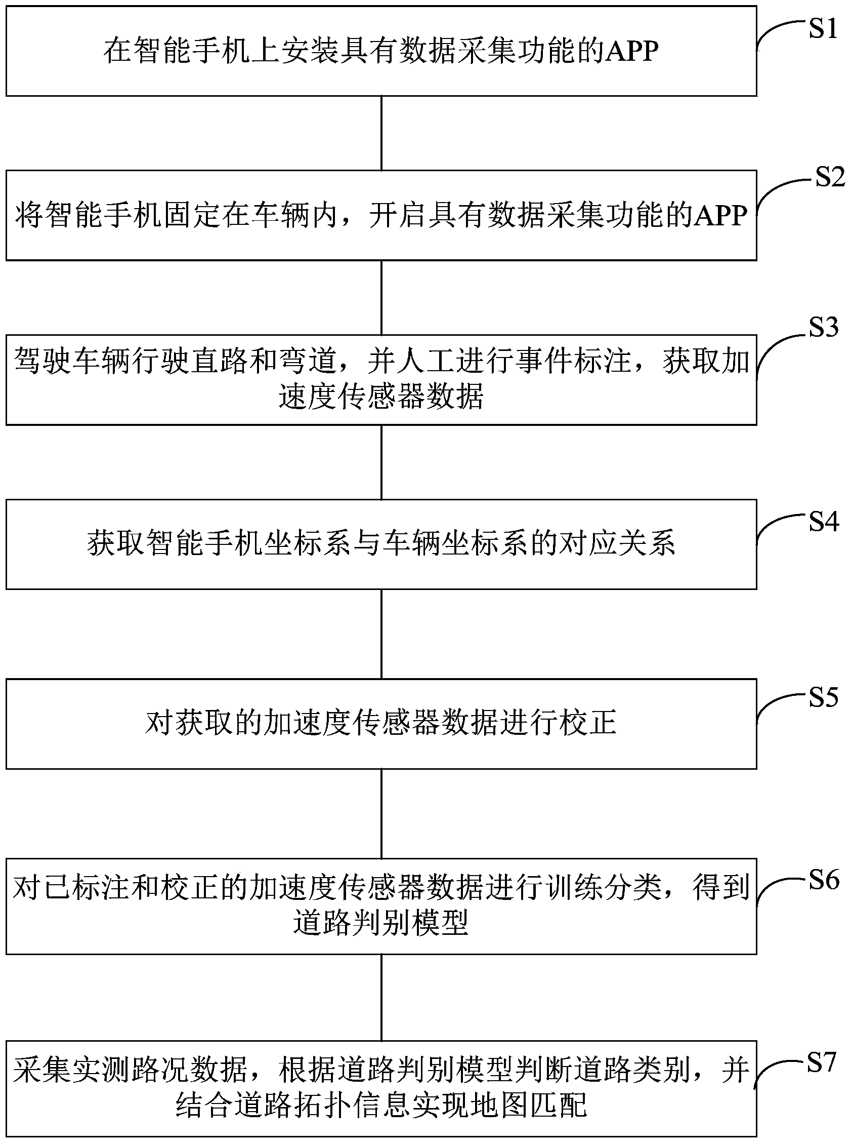
[0045] In order to enable those skilled in the art to better understand the technical solutions in the present invention, the technical solutions in the embodiments of the present invention will be clearly and completely described below in conjunction with the drawings in the embodiments of the present invention. Obviously, the described The embodiments are only some of the embodiments of the present invention, not all of them. Based on the embodiments of the present invention, all other embodiments obtained by persons of ordinary skill in the art without making creative efforts shall fall within the protection scope of the present invention.

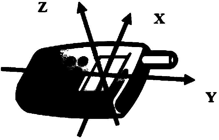
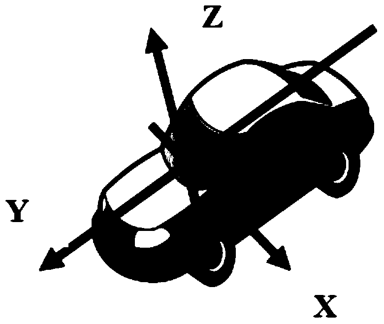
[0046] The invention is a method for correcting a navigation map based on the detection of curves on a smart phone platform. The smart phone sensor used is the built-in acceleration sensor and GPS receiving module inside the phone. Firstly, through the analysis of the data collected by the acceleration sensor, it is judged whether the ...


PUM


Abstract

The invention discloses a map matching method based on an intelligent mobile phone. The map matching method comprises the steps of installing an APP with the data acquisition function on the intelligent mobile phone; fixing the intelligent mobile phone in a vehicle, and starting the APP with the data acquisition function; driving the vehicle to run on a straight road and curves and manually marking events to acquire data of an acceleration sensor; obtaining a coordinate system of the intelligent mobile phone and a coordinate system of the vehicle; correcting the acquired data of the acceleration sensor; performing training classification on the marked and corrected data of the acceleration sensor to obtain a road judgment model; collecting actually-measured road condition data, judging the type of the road according to the road judgment model, and realizing map matching according to road topological information. According to the map matching method based on the intelligent mobile phone, the curves are detected through a mobile phone sensor, and an existing navigation system is corrected, so that the precision of a civil GPS (global positioning system) and the inaccuracy of a map system can be compensated to a certain extent, a more accurate navigation service can be provided, and a driving behavior is safer.

Description

technical field [0001] The invention relates to the technical field of digital maps and map matching, in particular to a smart phone-based map matching method. Background technique [0002] With the development of the economy and the increasingly developed road traffic, people's travel has become more convenient. The traditional map has long been a history. The Global Positioning System (GPS) provides navigation assistance for people's travel today. The GPS system uses the transmission and correction of the position signal of the receiving end transmitted by multiple satellites to realize the position positioning of the receiving end. The constellation system composed of 24 satellites can almost cover the whole world. Now our common vehicle system is the combination of GPS system and geographic information system (Geographic Information System, GIS), using the map information of the road position in the electronic map to compensate the problem of low positioning accuracy of ...

Claims


Application Information

Patent Timeline
Patent Type & Authority Applications(China)
IPC IPC(8): G01C21/30
CPCG01C21/30
Inventor 黄晓霞陈新平王维语黄浩权王珊珊
Owner SHENZHEN INST OF ADVANCED TECH
Why Eureka
Try Eureka